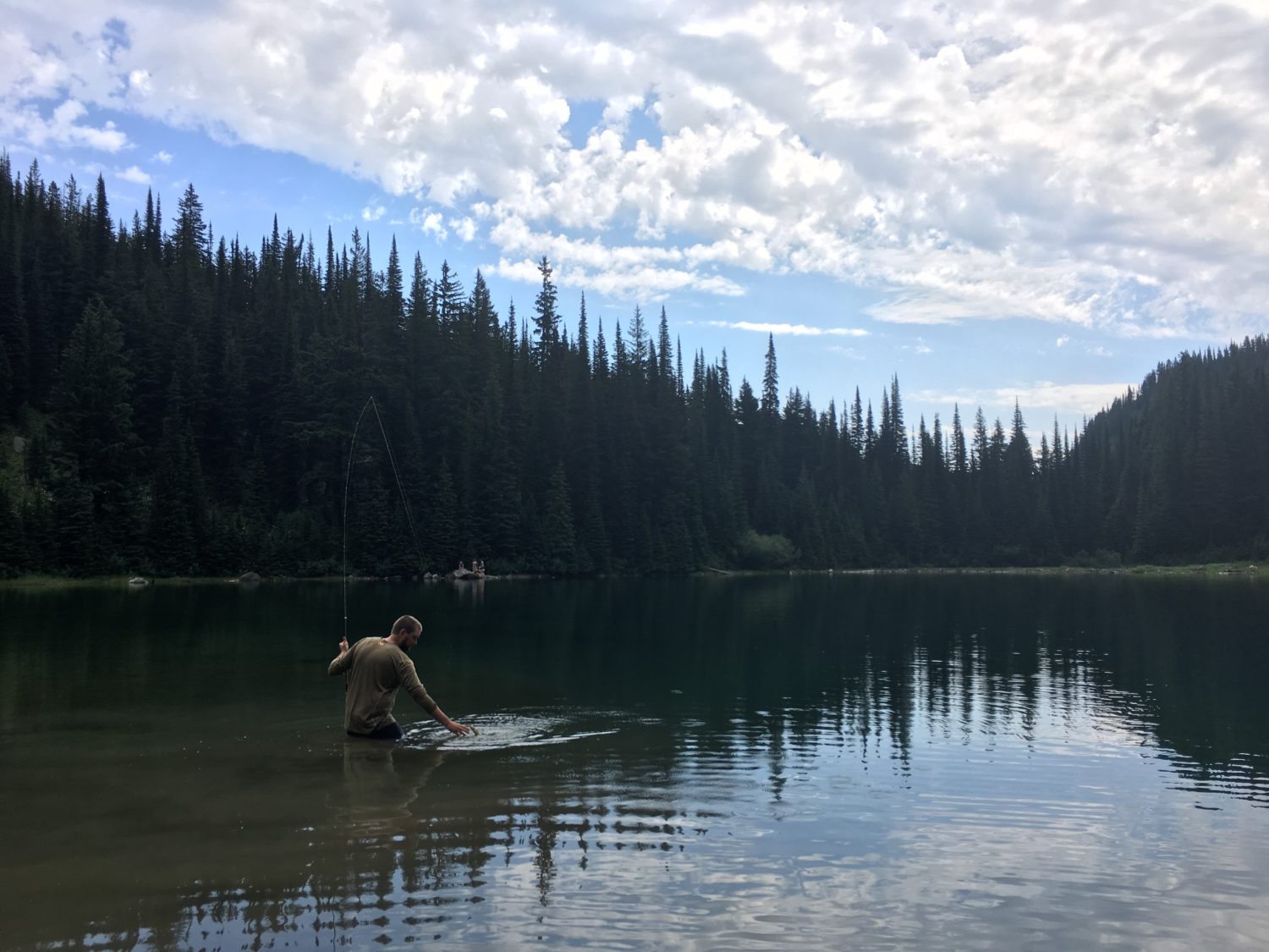
IMG_9072
Do you have any thoughts on this post?
What started as a washed out gravel road has become a naturally occurring sediment diversion that is helping to balance salinity levels and improve fish habitat south of New Orleans—to keep wetlands from disappearing, experts should keep Mardi Gras Pass and take control of its freshwater flows
The primary reason that nearly 2,000 square miles of prime fish and wildlife habitat have vanished along Louisiana’s coast is not erosion or development. It’s just that the land is constantly sinking, a phenomenon known as subsidence. While gradual, sea-level rise is already affecting coastal areas all over the world, and Louisiana is contending with rising water and sinking land.
Sediment delivered by annual flooding on the Mississippi River used to be the key to keeping coastal wetlands above the water line. But, when that sediment flow was cut off by flood-protection and navigation levees a century ago, wetlands started disappearing.
That’s why Louisiana’s coastal master plan calls for the construction of two major diversions, one east and one west of the river below New Orleans. Two control structures and canals will be built through the levees to deliver the sediment needed to help wetlands stay above the water line, serving as critical fish and wildlife habitat and better protecting coastal communities from storm surges.
Sediment delivery brings with it freshwater inundation, which will certainly change the makeup of the fisheries in the outfall areas. To minimize impacts to fisheries, the plan is to move water and sediment only when sediment loads are at their peak and cut back, or shut off, the diversions when river flows aren’t carrying as much sediment.
Extensive modeling has been conducted to try and predict the effects of the freshwater, but biologists have been careful to point out that there’s a degree of uncertainty considering river conditions, including sediment loads, water temperatures, and weather, in any given year.
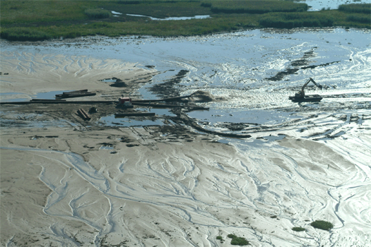
However, east of the river, near the small fishing community of Point a la Hache, hypotheticals can be replaced by a discussion of what is currently happening in the marshes, canals, bays, and lakes being inundated with freshwater and sediment from a break in the Mississippi River bank that has become known as Mardi Gras Pass.
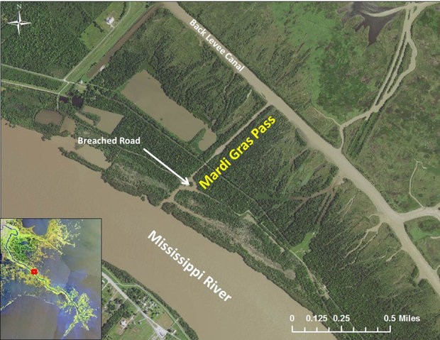
Mardi Gras Pass earned its name because the first time it was observed flowing freely from the river and down an existing canal was on Mardi Gras in 2012, a year after record flooding reshaped many areas along the east side of the Mississippi below New Orleans. The force of the flood washed away a gravel road and cut the bank around an old control structure that once allowed a limited amount of river water to spill into the area, controlling salinity and improving oyster habitat. What started as a tree-snagged trickle of less than 5,000 cubic feet per second has turned into an uncontrolled diversion that is estimated to be moving about 35,000 cubic feet per second—coincidentally, the same rate of water flow is prescribed for the diversion Louisiana has planned.
John Lopez, director of the Coastal Sustainability Program at the Lake Pontchartrain Basin Foundation, is the one who gave the new cut its name and has been studying the impacts of the natural diversion very closely. Early on, he saw schools of shad bunched up in the flowing water and has since documented a drastic increase in sediment pouring into adjacent marshes and bays. Submerged vegetation aided by the fresh water now fills ponds and bays from near the mouth of the pass out to the edges of Black Bay.
Waterfowl habitat has also improved. Bass populations have exploded in the area, and it has also become popular among tournament anglers who are finding redfish feasting on bluegills, crabs, shrimp, mullet, and crawfish. White shrimp are also more plentiful. Speckled trout, Louisiana’s most popular saltwater sportfish, have reacted to the seasonal changes in salinity by moving away from Mardi Gras Pass when the Mississippi River is high, but returning to the area when the river drops.
As is the case with any discussion of diversions, either existing or planned, not everyone is happy with the changes in the area. Oyster harvests on public oyster beds near Mardi Gras pass are down about 85 percent over the last decade, though it has been noted by Louisiana Department of Wildlife and Fisheries biologists that this decline began before the cut opened. The state’s Oyster Task Force recently voted to commit $200,000 to examine closing Mardi Gras Pass.
While the indication of negative impacts to oysters in public harvest areas and shifts in fisheries to more freshwater and freshwater-tolerant species is undeniable, closing Mardi Gras Pass would be a mistake. Controlling it with gates to maximize sediment delivery and force freshwater into adjacent marshes would be an optimal solution, especially since that’s what is recommended by those examining diversions in the Master Plan.
Simply plugging the hole and not allowing the river to flow at all is short-sighted. The Mississippi River is supposed to be connected to its adjacent wetlands. Any connection provides benefits to a sediment-starved system.
Coastal estuaries should be managed for a diverse array of fish and wildlife, not just oysters and popular sportfish species like speckled trout. If one of the primary solutions for trying to fix Louisiana’s ailing coastal wetlands is to reconnect them to the river that once built them it sure doesn’t seem to make a lot of sense to completely sever one of the few existing connections between river and marsh.
First image courtesy of LPBF.
Eddy, Harding, and Mora county commissioners join a growing list of local decision makers issuing official statements of support for the value of public lands in their communities
Yesterday, the Board of County Commissioners for Mora County, N.M., passed a resolution affirming their commitment to keeping public lands in public hands. This action underscores a local movement, with Eddy and Harding county commissions having approved similar resolutions this summer, and a groundswell of support for public lands across the West.
This local opposition to the state takeover of public lands supports every American’s ability to hunt, fish, and find solitude in the outdoors. Each county resolution recognizes the importance of public lands for basic economic activities such as:
“Public lands provide unparalleled hunting and fishing opportunities in our state,” says Jim Bates, an avid sportsman from Las Cruces, N.M. “I’m proud to live in a place where elected officials value public lands and see how unworkable and problematic the idea of state takeover is to millions of Americans. I hope that other counties across the West will take up this banner in support of our outdoor heritage.”
Mora County is home to the Mora River and Canadian River, which offer excellent trout fishing, as well as Ocate Peak and Old Santa Fe Trail, which are popular with hunters pursuing elk, pronghorns, mule deer, bears, cougars, turkeys, and various small game animals.
Eddy County—where commissioners passed a similar resolution on June 27— has approximately 2.5 million acres of public lands that are valued by sportsmen and women for their abundant opportunities to pursue elk, mule deer, Barbary sheep, pronghorns, bears, pumas, doves, quail, waterfowl, trout, and bluegills. In the northern part of the state,
Harding County passed its own resolution of support for public lands offering fishing, camping, hiking, and backpacking in the Canadian River Canyon, Mills Canyon, and Mosquero Canyon. The Kiowa National Grasslands is also a very popular deer hunting area.

“These elected officials have proven their commitment to America’s public lands and they should be commended by sportsmen beyond their county limits,” says John Cornell, New Mexico field representative for the Theodore Roosevelt Conservation Partnership. “This movement of support for keeping public lands accessible and well managed, which has been echoed in county governments across the West, further proves that New Mexico can be the posterchild state for strong coordination and multiple-use on our public lands.”
A total of 29 pro-public-lands resolutions have been passed by county and municipal governments across the West in the past two years—eight have now been passed in New Mexico. For links to these resolutions and other public statements of support for public lands, visit sportsmensaccess.org.
A handful of positive measures in the report are overshadowed by recommendations to reduce the size of several national monuments
In a report leaked to the press yesterday, Secretary Ryan Zinke recommends measures to protect hunting and fishing in ten of the 27 national monuments reviewed this summer, but the report also suggests modifying them in either size or scope of management. This includes reducing the size of four land-based monuments and two marine monuments, with an eye towards opening three marine areas to commercial fishing.
“I wish these recommendations were limited to protecting the ability of Americans to hunt and fish within national monuments and setting an example for the appropriate use of the Antiquities Act,” says Whit Fosburgh, president and CEO of the Theodore Roosevelt Conservation Partnership. “Instead, the handful of positive measures in the report are overshadowed by recommendations to reduce the size of several national monuments. Our hunting and fishing traditions are not threatened in most of the areas reviewed, and executive branch actions to diminish one monument could threaten the legitimacy of all national monuments, even those created by Theodore Roosevelt dating back to 1906.”
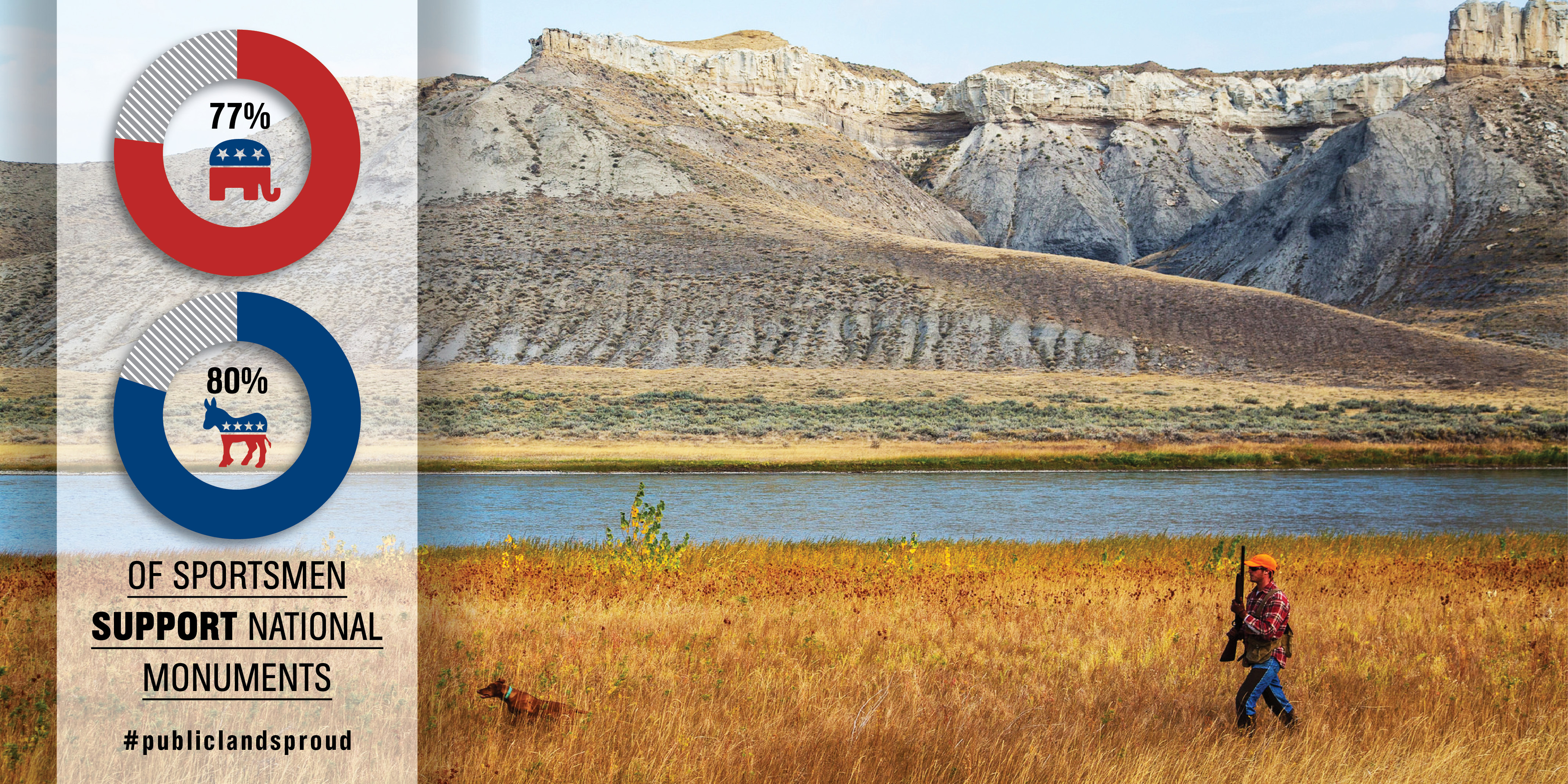
Of the 27 monuments reviewed by Secretary Zinke, 22 are open to hunting or fishing and are highly valued by sportsmen and women. Of the more than 1.3 million people who commented during the review period, more than 99 percent were in favor of keeping national monuments intact. Similarly, a recent poll commissioned by the TRCP found that 77 percent of Republican and 80 percent of Democratic sportsmen and women support keeping the existing number and size of national monuments available for hunting and fishing.
The move to open three marine national monuments to commercial fishing is not supported by recreational fishermen. “Saltwater anglers currently enjoy the privilege of using these areas, which are protected from the very real threat of overharvest,” continues Fosburgh.
Ultimately, decisions affecting the future of America’s national monuments rest with President Trump, and it is not yet clear what the White House will do with the recommendations.
“The TRCP encourages President Trump to support the integrity of the Antiquities Act by rejecting any measures to reduce the size of a national monument through executive action—sportsmen and women would rather be partners in using the Antiquities Act responsibly,” says Fosburgh. “Sportsmen don’t want to be used as a wedge in this process. If the president is most interested in supporting hunters and anglers, he will limit his actions under this report to protecting recreational hunting and fishing and supporting state agency authority over wildlife management.”
While the focus should absolutely be on helping victims of recent storms, there will come a time for reflecting on how to improve coastal resilience—these lessons from Hurricanes Katrina and Rita have changed the way that Louisiana views wetlands
My lifelong home in South Louisiana has borne the brunt of more than a dozen hurricanes over the last 40 years. Each of them brought flooding rains, heavy winds, and storm surges that inundated coastal communities. Some of them, like Hurricanes Katrina and Rita, reshaped cities and lives forever.
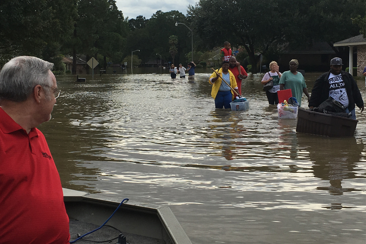
This is why it’s especially tough to see the devastation from Hurricanes Harvey and Irma affect friends, colleagues, and the places they call home. I’ve been there before—so have my friends and neighbors. We know it could just as easily be us gutting our homes, wondering when our roads will be passable, and struggling with seemingly endless power outages.
We understand the weeks, months, and maybe years of struggle ahead. The incredibly generous outpouring of support from fellow Americans, in the form of financial donations, volunteer hours, food, and water is critical to stabilizing the situation and beginning to rebuild. But anybody who has lived through such devastation knows only time, determination, and hard work will truly bring back a sense of normalcy for those in the paths of Harvey and Irma.
The focus for those directly affected—and for all Americans—should continue to be on aid for those who have lost their homes, vehicles, and schools or are struggling to find comfort without electricity, food, or water.
There will come a time, however, after this hurricane season is over and recovery is underway, when coastal residents, community leaders, and officials will begin to assess why the damage was so extensive.
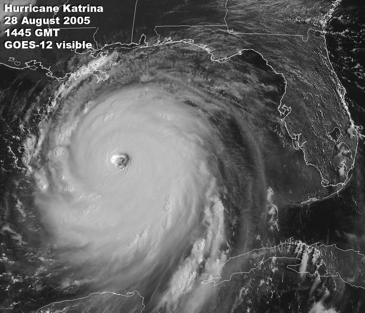
That reckoning occurred in Louisiana in late 2005, after Katrina and Rita brought absolute devastation from one end of the state to the other. Building codes were analyzed. Flood plain maps were examined and updated. Evacuation plans were closely critiqued. And, perhaps most critically, scientists and engineers began examining why flood protection systems failed so miserably.
Louisiana’s elected leaders had to deal with the fact that the incredible loss of wetland habitat along the state’s coast had likely exacerbated flood damages. Combined with the poorly conceived and maintained navigation channels through wetlands, the result was a woefully inadequate flood protection system.
Louisiana acted by creating a single agency responsible for both flood protection and wetlands restoration, rather than two agencies that might need to compete for the same funds.
In 2007, less than two years after Katrina and Rita, Louisiana’s newly created Coastal Protection and Restoration Authority released the state’s first comprehensive master plan addressing coastal restoration and hurricane protection. The plan laid out a 50-year effort to create a system with multiple lines of defense, using healthier wetlands and rebuilt barrier islands as a buffer to slow wave action and storm surge before it can reach flood protection levees and flood gates. Additionally, an examination of building practices in the most frequently flooded areas, some that had experienced severe flooding seven times in ten years, led to a concerted effort to elevate homes and make businesses more resilient.
An understanding spread among lawmakers and residents that marshes and swamps are not solely places to hunt and fish. This natural infrastructure is an absolute necessity for protecting Louisiana’s largest cities as well as the smaller communities that benefit from being hunting and fishing destinations.
For more than a century, many state and federal agencies and municipalities focused on conquering wetlands by draining them, then pumping in soils to create space for development. Wetland buffers along rivers, bayous, and creeks that once absorbed and held floodwaters were replaced by levees that force floodwaters up, instead of out. The ability of wetlands to help protect existing infrastructure was largely ignored.
It cannot be ignored any longer.
It’s true that no two storms are exactly alike: Hurricane Harvey dumped a record amount of rain that inundated a huge swath of southeast Texas, and Irma’s enormous size and unprecedented wind ferocity set it apart. Even the healthiest coastal wetlands and the best flood protection systems would not have staved off all the destruction caused by those two storms.
However, there are parts of the Houston area that have now experienced record-setting “100-year flooding” four times in the last 20 years. In Florida, communities now devastated by storm surge and river flooding could have been spared some damage if once-present mangrove flats were there to dampen wave action, or if rivers could still flush out into the wetland floodplains that no longer exist or have been cut off.
Acknowledging these facts is not an attempt to assign blame. It’s not an attempt to use unprecedented disasters to advance a political ideology, either. I understand the crassness of using these disasters as fodder for advancing an agenda while those affected try to save what few possessions remain.
I have neighbors in Baton Rouge who still have not been able to move back into their homes after record flooding in August 2016. The house that my grandfather built, where my dad grew up just two miles from Lake Pontchartrain in New Orleans, still sits empty and in disrepair more than a decade after Hurricane Katrina.
What I hope is that this will be read as a plea to those who make the decisions in coastal communities that have and have yet to be impacted by a disaster. We must grasp how important it is that we live with and utilize the natural protections for our man-made infrastructure—and perhaps think of wetlands, marshes, and mangrove flats as something just as critical to the way we live on the coast.
With personal experience as our guide, I hope we rebuild smarter in flood-prone areas, so recovery isn’t quite as difficult the next time. The side benefit just might be that we support or improve habitat that makes it possible for us to hunt, fish, and live well.

Theodore Roosevelt’s experiences hunting and fishing certainly fueled his passion for conservation, but it seems that a passion for coffee may have powered his mornings. In fact, Roosevelt’s son once said that his father’s coffee cup was “more in the nature of a bathtub.” TRCP has partnered with Afuera Coffee Co. to bring together his two loves: a strong morning brew and a dedication to conservation. With your purchase, you’ll not only enjoy waking up to the rich aroma of this bolder roast—you’ll be supporting the important work of preserving hunting and fishing opportunities for all.
$4 from each bag is donated to the TRCP, to help continue their efforts of safeguarding critical habitats, productive hunting grounds, and favorite fishing holes for future generations.
Learn More
