40936638593_39812cc23e_k_photo-by-Lisa-Gleason-BLM-900-web
Do you have any thoughts on this post?
TRCP’s “In the Arena” series highlights the individual voices of hunters and anglers who, as Theodore Roosevelt so famously said, strive valiantly in the worthy cause of conservation
Hometown: Kansas City, Missouri (now resides in Oro Valley, Arizona)
Occupation: Retired Navy F/A-18 Pilot
Conservation credentials: Chapter President of Southern Arizona Quail Forever, which last year was awarded a Commendation of Achievement by the Arizona Game and Fish Commission for the organization’s work to improve quail habitat on the Coronado National Forest near the U.S.-Mexico border. SAQF volunteers built about 100 loose-rock dams which slow the runoff of water, retain soil, and provide habitat.
Growing up in Missouri, Zack May developed a lifelong interest in fish and wildlife. After a career as a pilot in the Navy flying F/A-18s, he settled down in southern Arizona and quickly grew a strong connection to the region’s landscapes and outdoor opportunities. A dedicated bird hunter (pictured above volunteering for a quail wing collection survey), he now serves as the chapter president of Southern Arizona Quail Forever, hoping to use his role there to ensure a brighter future for the species, lands, and traditions that he has enjoyed.
Here is his story.
I was introduced to hunting and fishing by my grandfather who had a farm in eastern Kansas. Those early experiences gave me a passion for the outdoors that stuck with me.
My favorite hunting experiences are anytime when I’m out with my dog. I love to watch a dog work. They are the best hunting partner you can have.
There’s no place I’d rather hunt than right out my backdoor here in Southern Arizona. We’re fortunate to have beautiful country and a wide diversity of quail and other wildlife
At this point in my life it is very important to me to give back and do all that I can to ensure future generations have the same opportunity I have had. The organization I’m a part of, Southern Arizona Quail Forever, hosts an annual family day and youth hunt. It’s a great chance to get people outside and teach them different skills.
We are made up of a lot of hunters, but we welcome non-hunters to our organization as well. Anybody who is interested in getting people out onto the landscape and supporting wildlife habitat, we want all those folks to feel welcome and to work with us to do great things.
I want to get as many folks outdoors as possible. If we do not increase the numbers of hunters, the North American Model of wildlife conservation will not be sustainable. We need to get our youth involved, as well as their parents, especially sisters and moms.
America has a special legacy of wildlife and outdoor traditions. We cannot afford to lose these opportunities and let the outdoors become accessible to only a few.
Landmark new legislation in Congress promises to bring public land access into the 21st century
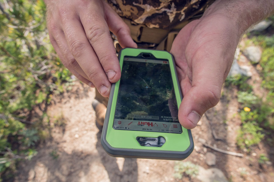
Digital mapping and GPS technologies have revolutionized the ways in which sportsmen and women navigate public lands. By pinpointing a user’s real-time location on the landscape, handheld GPS units and smartphone applications allow hunters and anglers to know exactly where they stand relative to property boundaries and other key landmarks.
Unfortunately, when it comes to public lands, incomplete and inconsistent mapping data prevents hunters and anglers as well as land management agencies—including the Forest Service, Bureau of Land Management, National Park Service, and Army Corps of Engineers—from utilizing the full benefit of these technologies.
But a bipartisan bill recently introduced into both chambers of Congress promises to bring our public land mapping records into the 21st century. Here’s how the Modernizing Access to our Public Land (MAPLand) Act would do that.

Most recreational opportunities on public lands are identified in agency management plans and appear on agency-produced paper maps that show, for instance, roads and trails open to different types of motorized and non-motorized vehicles. Sometimes alongside a national forest road you’ll see a sign marking a zone where hunting or recreation shooting is, such as near a campground or forest service ranger station. Other times you’ll pull up to a mountain lake parking lot and a sign is posted that specifies horsepower restrictions for boats.
While some of this information might, in certain places, be available in a GPS-compatible format, in most places it is not. As a result, it is difficult for the general public to find specific information about available recreation opportunities on their public lands without spending considerable time exploring public lands to ground-truth areas or poring over volumes of agency documents. Sometimes, a person might avoid hunting in an area altogether simply because they can’t tell by looking at a sign where the shooting boundary starts and ends. Many members of the public might also avoid driving on an open road because the existing sign long ago went missing and they don’t want to inadvertently break the rules.
A lack of modern information about recreational access opportunities on public lands is resulting in lost days afield, and in the 21st century, sportsmen and women should be able to reference their handheld GPS or other mapping units so that they can instantly know the rules for recreation and where the boundaries of restricted areas are located within a matter of feet. Such measures would not only help busy Americans discover new recreation opportunities and give them confidence to enjoy the outdoors, but it would also reduce conflicts and the likelihood that outdoor enthusiasts will break the rules.
This need for better information is what the MAPLand Act is designed to address by providing funding and guidance to our land management agencies to digitize mapping information about outdoor recreation. This includes, among other things, seasonal allowances and restrictions for vehicle use on public roads and trails; boundaries of areas where hunting or recreational shooting is regulated or closed; and portions of rivers and lakes on federal land that are closed to entry, closed to watercraft, or have horsepower limitations for watercraft.

Millions of acres of federal public lands across the country have restricted access, particularly in areas with mixed public and private landownership. In the West alone, more than 9.52 million acres of federal public lands have no permanent legal means of access and permission to access to public lands across private property can be difficult to obtain.
In many places where public land trail and road access exists across private land, it was established by a legal agreement known as an easement, in which an agency such as the BLM or Forest Service formally acquired the permanent right for the public to travel a designated route (such as a road or trail) across private land.
Many of the agencies’ records of access easements across private lands are still held on paper files at local offices and cannot be easily accessed or reviewed. The Forest Service alone has an estimated 37,000 recorded easements, but only 5,000 have been digitized and uploaded into an electronic database.
Currently, the federal land management agencies lack the resources and capacity to digitize and standardize these records. Because of this, it is difficult for hunters and anglers to understand the full extent of access opportunities. And when they are not used, public rights-of-way can be forgotten by the public and the agency alike.
MAPLand would require our public land agencies to digitize records of easements or rights-of-way across private lands, making it possible for the public to understand where public access has been formally secured in legal records. Doing so would both help expand public access opportunities and reduce conflict with landowners, because everyone would have factual information about access allowances and restrictions.
In addition, by giving land managers a comprehensive picture of all available access points, they can fulfill their mission to identify public lands with limited or nonexistent public access, and take proactive steps in cooperation with private landowners to open those lands to the public. Conservation groups and land trusts that have been working on access issues will be able to use this data to identify priority areas and work more efficiently to expanding opportunities on our public lands.
Elected officials need to know how much MAPLand would mean to hunters and anglers. Write your lawmakers today and ask them to support public land access!
Top photo: Rick Hutton
President and CEO of the Theodore Roosevelt Conservation Partnership Whit Fosburgh issued the following statement on the spread of COVID-19:
“As communities across the world are impacted by COVID-19, we want to reiterate our commitment to our staff, our partners, our donors, and the sportsmen and women who are all ‘in the arena’ working together on behalf of conservation. Your health is our top priority.
During this time, we are adjusting our operations to keep our community safe, so we can continue the important work of guaranteeing all Americans quality places to hunt and fish. All TRCP staff are being encouraged to work from home. Travel has been suspended and in person meetings are being replaced with virtual meetings. Our Capital Conservation Awards Dinner has been moved from April to September. Through this time, we will continue to engage in policy that matters to all sportsmen and women.
As President Theodore Roosevelt said, ‘In any moment of decision, the best thing you can do is the right thing, the next best thing is the wrong thing, and the worst thing you can do is nothing.’ ”
Image courtesy of Charlie Bulla
Here’s why MAPLand could be a game-changer for unlocking inaccessible public lands
When onX and TRCP teamed up in 2018 to study the issue of landlocked federally managed public lands in the West, we highlighted several priorities that needed to be addressed by agencies and lawmakers in order to work on opening access to the 9.52 million acres of public lands in the West where it currently does not exist.
Here’s what we had to say about the need for digitized, standardized easement data, which helps explain why the MAPLand Act is such a critical piece of legislation.
TRCP has partnered with Afuera Coffee Co. to further our commitment to conservation. $4 from each bag is donated to the TRCP, to help continue our efforts of safeguarding critical habitats, productive hunting grounds, and favorite fishing holes for future generations.
Learn More
Sign up below to help us guarantee all Americans quality places to hunt and fish. Become a TRCP member today.

For every $1 million invested in conservation efforts 17.4 jobs are created. As Congress drafts infrastructure legislation, let's urge lawmakers to put Americans back to work by building more resilient communities, restoring habitat, and sustainably managing our water resources.