Background: In 2007, the Theodore Roosevelt Conservation Partnership (TRCP) began the Sportsmen’s Values Mapping Project (SVMP) in Montana by working with sportsmen’s groups and the Montana Department of Fish, Wildlife & Parks to gather information about the most important hunting and fishing areas. The project was expanded to Wyoming in 2011 and to Arizona and Idaho in 2014.
Project goals: The mission to guarantee every Arizonan quality places to hunt and fish is shared by the Arizona Game and Fish Department, the TRCP, and many Arizona sportsmen groups. No matter how many deer, elk, turkeys, quail, or trout fill our lands and waters, hunting and fishing as we know it could become a thing of the past without access to quality places to hunt and fish.
The Arizona Sportsmen’s Values Mapping Project was designed to gather input from Arizona sportsmen and women about our state’s most-valued places to hunt and fish. While information on critical fish and wildlife habitat is generally available, organized information on the areas that sportsmen value most for hunting and fishing is lacking. A highly valued area may not always be the area with the greatest fish and wildlife populations—it may be a favorite trout stream that is close to home, an elk hunting area that a family returns to each season for many years, or a deer hunting unit where it’s easy to draw a tag.
This mapping project directly involves hunters and anglers in issues that affect them to ensure that their interests are represented in land-management decisions.
Postcard Mail Survey: In the fall of 2015, a random sampling of 7,500 Arizona residents who had purchased state hunting and fishing licenses were invited by postcard to participate in the survey. Those who received the postcard were directed to a specially designed website, where they could highlight their most-valued hunting and fishing destinations on a map. More than 1,100 individuals participated in the survey.
Final Maps: Utilizing data from the surveys, final maps (attached) were created, and are now available here. The site features maps for 15 species of interest, including elk, mule deer, whitetail deer, bighorn sheep, javelinas, predators, pronghorns, cold-water fish, warm-water fish, waterfowl, turkeys, quail, doves, squirrels, and other small game. The survey also included questions about why sportsmen identified an area as being important. Findings show that the highest-valued areas are usually those that offer the greatest chance of harvesting game, but other primary factors are the proximity of an area to home, whether it has been someone’s spot traditionally, or if the area provides an opportunity to harvest a trophy-size animal or fish.
Benefits and Uses: While the maps may be used by some to identify hunting and fishing areas with promise, they were developed primarily to guide conservation efforts. The maps have been assembled in a geographic information system (GIS), where they can be overlaid with maps of critical habitat, migration routes, land ownership, and other data. The resulting maps will provide important and previously unavailable data to state and federal agencies, allowing them to:
• Balance other land uses with the needs of fish, wildlife, and sportsmen
• Identify areas needing stronger conservation efforts, or expansion of hunting and angling opportunities
• Identify key high-use areas warranting special conservation strategies, because of their value to sportsmen
• Justify actions and funding requests aimed at conserving highly valued wildlife habitat and hunting and fishing areas
• Identify areas where public access needs to be maintained or improved
Project Supporters and Cooperators: The TRCP’s project has been endorsed by the Arizona Game and Fish Department (AZGFD), Trout Unlimited, the Arizona Antelope Foundation, the Arizona Elk Society, the Southeastern Arizona Sportsmen’s Group, the Arizona Chapter of the National Wild Turkey Federation, and the Arizona Sportsmen for Wildlife Conservation, an alliance of 25 other Arizona sportsmen’s groups.
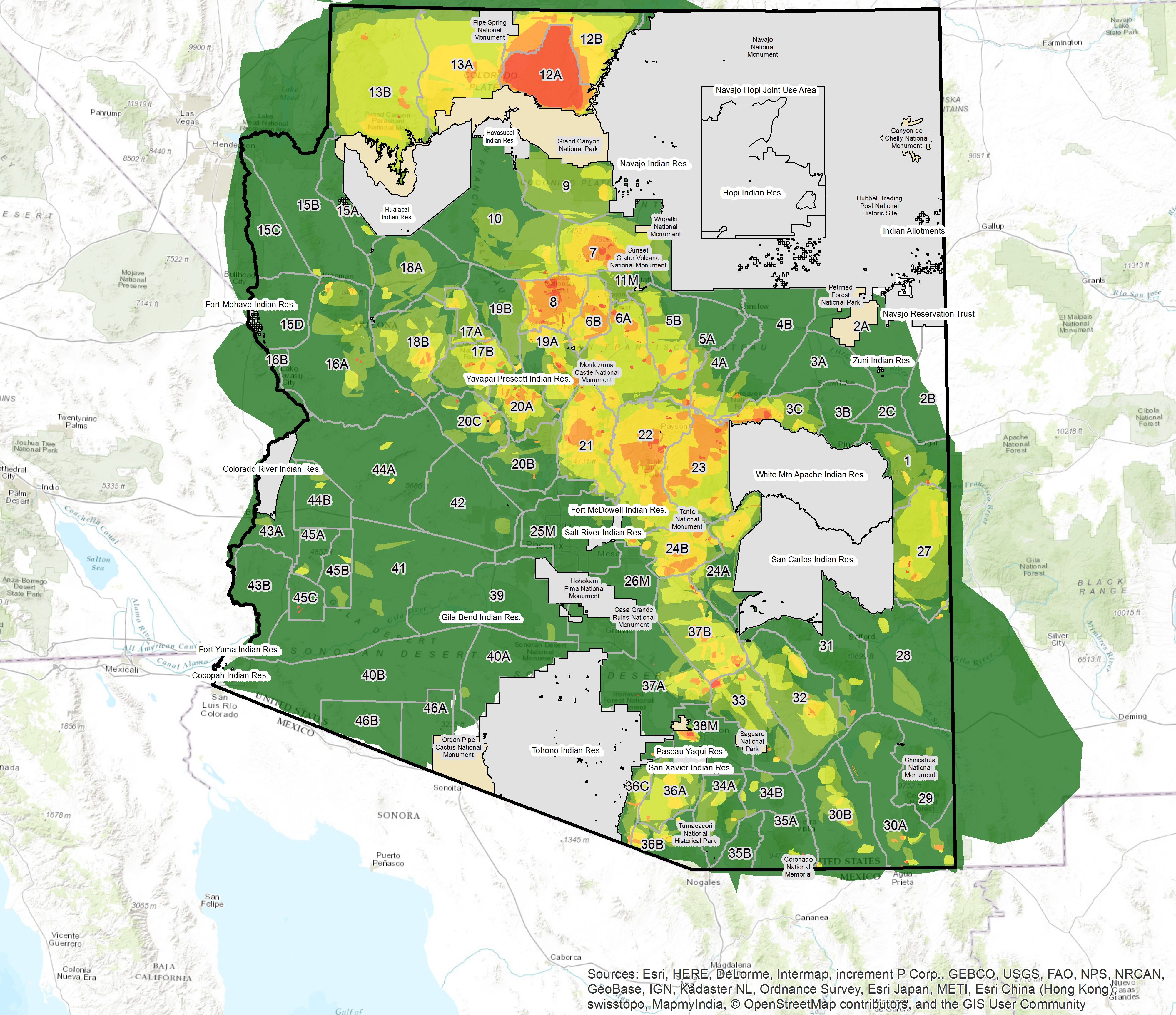
Most Highly Valued Mule Deer Hunting Locations in Arizona
The Sportsmen’s Values Mapping Project captures input from local hunters and anglers to delineate the areas that they value most for hunting and fishing. This heat map depicts the most highly valued locations where survey respondents report they prefer to hunt mule deer. Red areas were valued the most, yellow areas were valued less, and green the least. Tribal lands and National Parks are blanked out. Maps for 14 other species or species groups are available here.

Contact Information:
John Hamill, Arizona Field Representative
Theodore Roosevelt Conservation Partnership
Flagstaff, AZ 86004
928 606-4234
jhamill@trcp.org


