fbpx

Why Giving Rivers Space to Flood Helps Fish, Wildlife, and Communities

Levees built right on the riverbank were once the golden standard for preventing dangerous flooding, but setting structures back from the river could help communities faced with increasingly costly storms, while improving habitat

As common flood protection structures, earthen levees line American rivers and streams. Levees constructed in response to historic river flooding—where property damage soared and life loss steadily increased—have been relied upon for generations.

But these manmade barriers also work against our natural environment. Connectivity of a river to its floodplain is critical for the exchange of flows with the river, which deposit and transport sediment through the watershed and support the sustainability of fish and wildlife populations. Levee construction across our major river systems has interrupted and prevented this natural and beneficial ecological function of floodplains.

Over time, Congress acknowledged the adverse impacts of human development that depletes habitat by passing the National Environmental Policy Act in 1970 and the Endangered Species Act in 1973, among other legislation. But levees are still used today. Fortunately, there is a way to make communities more resilient from flooding and reconnect habitat that relies on life-giving sediment and river flows.

It’s Not a Question of Whether Levees are Good or Bad

Numerous levees have performed and continue to perform as they were originally intended. Just ask someone from the U.S. Army Corps of Engineers. For that matter, just ask me. After 34 years of service with the Corps, I’ve seen the good and the bad associated with levees.

On the one hand, levees have prevented devastating flooding from occurring in large cities and small towns—protecting critical facilities (like hospitals, fire and ambulance stations, utility distribution services, government buildings, and military bases) as well as acres upon acres of productive farmland.

However, many of these levees were designed before we began experiencing the apparent effects of climate change, which could pose higher risks now and in the future.

A levee’s height and width will not change once it has been constructed. No matter how much you water it, that levee will not grow. The design conditions are static, with levee performance being based upon the hydrology and hydraulics from when the levee was originally designed. Unfortunately, the climate is dynamic and, as we have witnessed over the past decade, the intensity and frequency of severe weather is increasing along with the failure of vulnerable levees—most recently within the lower Missouri River Basin.

When a levee fails, the results can be catastrophic to people, buildings, infrastructure, livestock, and cropland. Setting levees back far enough to allow the river more room to convey flood waters, while protecting all landward assets, could solve multiple problems.

The photo on the left below illustrates the devastation to the land after a levee breach occurred along the Missouri River during the 2011 flood. The photo on the right illustrates the levee setback that was implemented after the flood, improving flood conveyance, reducing the depth of inevitable floods, and increasing the resiliency of the levee.

Levee breach and levee setback located along the Missouri River. Photos by U.S. Army Corps of Engineers.

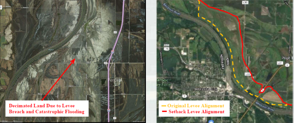
Further, the land located riverward of the levee has been enrolled into conservation easements, reconnecting a large portion of the historic floodplain and allowing for that critical exchange of flow between the river and the floodplain.

Environmental Benefits of Levee Setback Projects

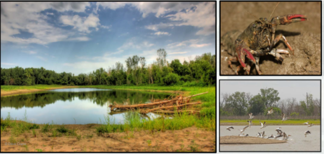
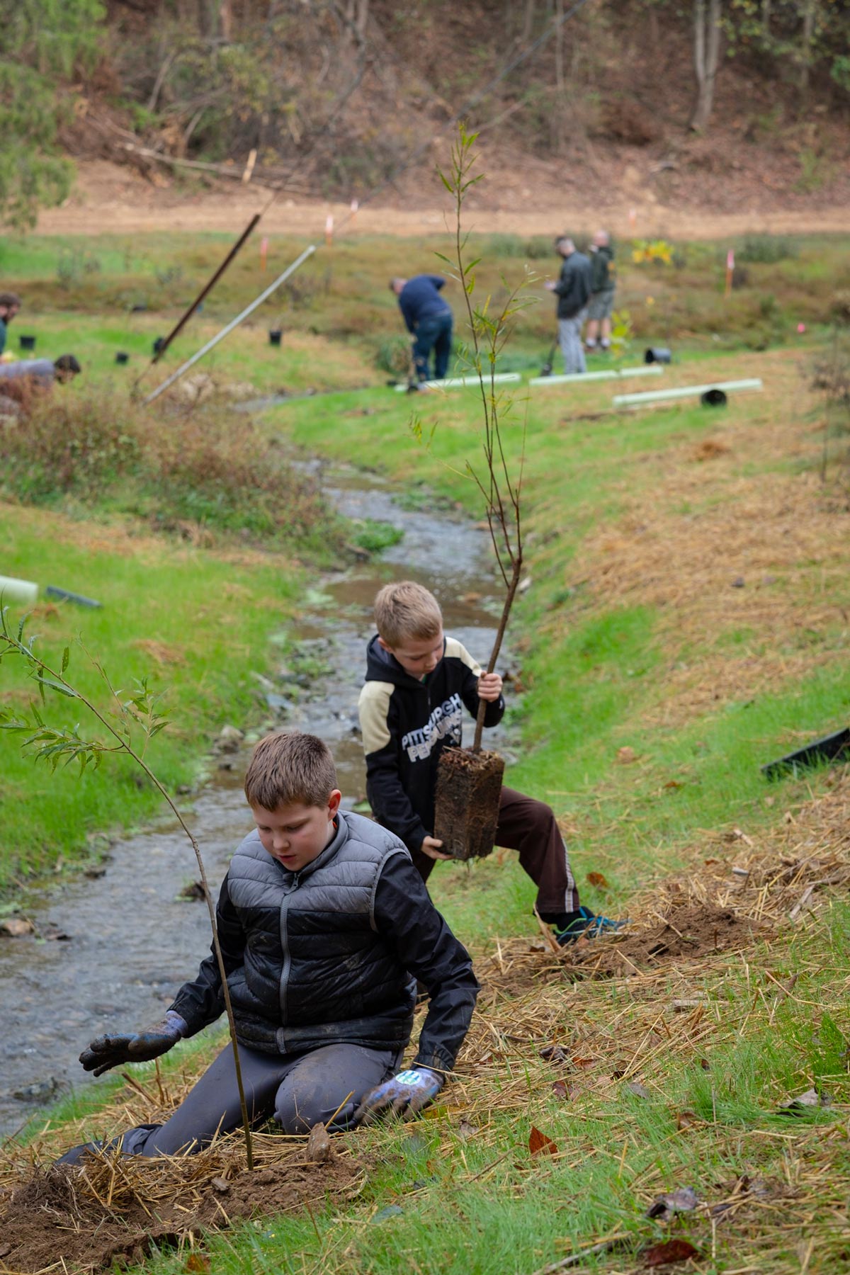
Diversification of flood flows through reconnection of the historic floodplain to the river is the greatest environmental benefit associated with a levee setback like this one. As shown in the images below, fish and wildlife are flourishing within the conservation easements, because they mimic natural ponds and wetlands. The positive trade-off of transitioning some productive cropland to conservation easements by realigning the levee is that fewer levee failures will occur, the setback levee is more resilient to flooding, and the environment has an opportunity to recover.

View of fish and wildlife using conservation easement near a setback along the Missouri River.
Consider the Setbacks

The cost of setting a levee back from the river can be millions of dollars. The cost of not setting back certain levees, especially those that continue to encounter flood damage, may be costlier in terms of damage to buildings, infrastructure, livestock, cropland, and the environment. While funding from the federal government flows with fewer restrictions to states and local governments after a disaster, it would be beneficial for states and federal agencies to identify vulnerable levees now—prior to flooding.

We must acknowledge that our needs have changed since levees were first designed and constructed. Continuing to rebuild after every damaging flood, rather than implement forward-thinking solutions, like levee setbacks, all but guarantees that fish and wildlife habitat will continue to suffer.

Learn more about this issue and proposed solutions here.

Randall Behm is retired from the U.S. Army Corps of Engineers after 34 years as a professional engineer. As a consultant, he now works nationally on the implementation of nonstructural flood mitigation measures and advocates for the setback of perennially damaged levees to improve flood-risk management and environmental benefits.

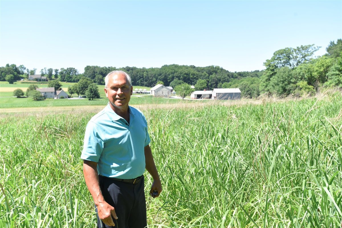
Top photo by Justin Wilkens on Unsplash

2 Responses to “Why Giving Rivers Space to Flood Helps Fish, Wildlife, and Communities”

  1. Jim Sweeney

    I would like to see every state and federal agency commit to a national program of moving levees back from the rivers. As is, we get some benefits from current levee construction but a national program of moving levees back with produce many more benefits than just flood control. Water quality, less flooding and erosion, and fish and wildlife benefits would be huge and pay multiple dividends. Great article.

Do you have any thoughts on this post?

XHTML: You can use these tags: <a href="" title=""> <abbr title=""> <acronym title=""> <b> <blockquote cite=""> <cite> <code> <del datetime=""> <em> <i> <q cite=""> <s> <strike> <strong>

Comments must be under 1000 characters.

June 21, 2021

How Reducing Farm Runoff in PA Streams Benefits More Than Just Fishing

The state’s plan to send fewer nutrients downstream to the Chesapeake by 2025 will also boost whitetail and pheasant habitat, farm operations, stream connectivity, and more

Lancaster County farmer Roger Rohrer waded through swaying switchgrass on a hillside overlooking his fourth-generation poultry and crop farm. Two whitetail does jumped up and porpoised into nearby woods. Nearby, he showed a visitor a 20-year-old wooded buffer with tall grass underneath that traced a small but clear meandering stream with no name.

Planting steep fields in warm-season grass cover and placing vegetative filters along a stream prevents soil and fertilizer on adjacent fields from running off and ending up in Chesapeake Bay, a threat that contributes to algae blooms and smothers key underwater grasses.

To Rohrer and his sons—all hunters—these changes not only bring the satisfaction of doing the right thing for the environment. Their hunting opportunities and wildlife sightings have boomed. Instead of driving to deer camp upstate, they now shoot trophy bucks each year on the farm. The whitetails use the riparian buffers as travel lanes and the grassy fields as bedding areas.

For the first time, turkeys are around, gobbling from nearby forest ridges. They use the grasses as nesting areas and to hide from predators. Ducks have appeared on the stream.

Lancaster County’s Roger Rohrer in a 20-year-old forested buffer on his farm. The buffer is used by trophy bucks for travel corridors. Photo by Ad Crable.

“Everything you do to enhance wildlife is also good for water quality,” says Rohrer, who has become something of an activist in pushing to restore riparian forests. For Rohrer and Pennsylvania sportsmen, there are many side benefits of the state’s massive commitment—almost $5 billion so far—to reduce nutrients and soil from running into the Bay.

Pennsylvania’s latest blueprint to try to reach its promised nutrient and soil reductions by the 2025 deadline is known as Watershed Implementation Plan Phase III, or WIP III. It includes a number of new initiatives and accelerated strategies that will benefit anglers, hunters, and anyone who uses the outdoors or cares about clean water.

For example, the new plan puts a premium on land conservation practices that enhance fish habitat or create other ecosystem benefits. And buffers will be favored if they bring contiguous stretches of waterways together to better support fish populations.

In setting a goal of 83,000 acres of new forested buffers along streams, WIP III specifically mentions how creating shade along streams may help buffer sensitive native brook trout, the state fish, from the warming effects of climate change. And, as Rohrer found out, the strips serve as travel corridors for game.

A forested buffer along a Pennsylvania stream. Buffers with trees are one priority for the state’s new blueprint for meeting pollution goals to help restore the Chesapeake Bay. Photo by Pennsylvania Department of Conservation and Natural Resources.

Ryan Davis used to work with Pheasants Forever in western Pennsylvania. He was so impressed at how streamside buffers attracted pheasants and other wildlife that he became a full-time advocate for riparian buffers and forest restoration with the Alliance for the Chesapeake Bay. Though pheasants are becoming an uncommon game bird on the Pennsylvania landscape, Davis has seen concentrations of ringnecks in buffers.

“These kinds of scruffy, brushy habitats are essential for pheasants to survive over the winter,” he says.

A long-lasting scourge from past land abuses, acid mine drainage is next to agriculture in polluting streams in Pennsylvania. But cleanup projects under the Bay restoration have restored more than 55 miles of streams from 2010 to 2018, in many cases allowing native fish and insects to move back in.

“Many streams that were once heavily polluted are now places where residents gather to swim, fish, boat and play,” says one section of the implementation plan.

Land conservation is another key strategy of the plan. “That protects existing habitats and hunting grounds from conversion to other land uses,” notes Wesley Robinson of the state Department of Conservation and Natural Resources.

The WIP’s call for more conservation of forest land is just as important for sportsmen and sportswomen as it is for the Bay. These local hunters and anglers are called “among our best stewards of the environment” by Michelle Price-Fay, acting director of the federal Environmental Protection Agency’s Chesapeake Bay Program Office.

The rallying cry from Pennsylvania officials in recent years has shifted from save-the-bay to touting the benefits of making local streams clear for Pennsylvanians’ sake, where better water quality in the Bay is an added benefit.

Pennsylvania farmer Roger Rohrer stands in switchgrass planted on a sloped former crop field to prevent nutrients and soil from running into streams and eventually the Chesapeake Bay. The grasses have attracted deer and turkeys. Photo by Ad Crable.

Of nearly 49,000 miles of Pennsylvania streams in the Bay drainage—about half the state—more than 15,000 miles remain polluted or impaired in official terms.

“Failing to restore Pennsylvania’s impaired waters will mean that our drinking water sources, outdoor recreation, wildlife, and public health and safety will remain impacted,” the WIP III states.

The plan draws on a number of federal partners that have land in the state. For example, the U.S. Army Corps of Engineers has a goal in WIP III to restore, enhance, and preserve wetland habitat to support 100,000 black ducks baywide. In Pennsylvania, that would focus on 54,000 acres of wetlands in the Elk River watershed in the southeastern part of the state. The Corps also seeks an 8-percent increase in brook trout water in headwater streams.

The biggest target of WIP III is agriculture, which is next to forest cover as the biggest land use in the state. A closer bond between sportsmen and farmers “represents a huge opportunity for habitat restoration for game species,” suggests Lamonte Garber of the Pennsylvania-based Stroud Water Research Center. “Strengthening ties between conservation-minded farmers and sportsmen can only help improve Pennsylvania’s sporting resources.”

Take action now to support conservation investments in Pennsylvania.


Ad Crable lives in Lancaster, PA, writes an outdoors column for LNP newspaper, and covers Pennsylvania environmental issues for the Chesapeake Bay Journal.

Top photo by Derek Eberly


Restoring 350 Miles of Impaired Streams in PA’s Amish Country

Years of planning and collaboration, especially with local farmers, could make this a model of success for at-risk fish habitat across the country

With its Amish farms and quaint architecture, Pennsylvania’s Lancaster County is a tourist destination where people hope for a glimpse of the past. With its urban sprawl, disappearing farmland, and impaired waterways, it now offers, rather more tellingly, a good look at the future.

That future just got a good deal brighter. Let’s set the stage.

Photo by Derek Eberly.

Lancaster County is home to some 550,000 souls, roughly double the population of 80 years ago. The increase in population has brought in quite a few sportsmen and sportswomen, but also all of the environmental threats that go with urbanization and industrial and transportation development. This has coincided almost precisely with the age of chemical agriculture, with pesticides, herbicides, and liberal application of fertilizers having become the norm.

The result? More than half of the county’s 1,400 miles of stream are listed by the federal Environmental Protection Agency as impaired. Taken together, we may have more hunters and anglers but ever fewer places to hunt and fish in a seemingly inexorable trend.

There’s every reason to hope that the trend is about to be reversed. Lancaster Water Partners has received $7.4 million from the Natural Resources Conservation Service to commence what may become a massive cleanup.

The goal is to take 350 miles of Lancaster County streams, or close to half of the area’s degraded waters, off the EPA’s impaired list by 2030. That’s an ambitious agenda for such a sum, but the key element is collaboration.

Some government agencies and nonprofits are important partners, but the most impact may be had by the farmers in stream catchments areas. By cooperating in the program and voluntarily improving their management practices, the farmers can reduce the sediment and nutrient loads that landed the streams on the impaired list in the first place.

Education and public awareness, therefore, are also part of the goal of the project. Sponsors hope for 75 percent of the county’s adult population to be aware of the work, and to support it, by the time this phase is complete.

Photo by Derek Eberly.

One important partner, the Chesapeake Conservancy, has used advanced geographic information system techniques to create maps that will serve as a starting point for determining stream needs and the best candidates for restoration. So far, 19 catchments have been identified in the Conestoga, Chiques, Pequa, and Octoraro watersheds.

This strategic approach is the result of years of planning. Now, we need to make sure there’s robust and dedicated funding moving quickly where it’s needed to get shovel-ready projects started and people back to work.

There is likely to be a considerable lesson here. Lancaster County is by no means the only place with impaired streams, and agriculture is not the only culprit. From acid rain to abandoned mine tailings and industrial waste, all manner of pollutants have degraded waterways across the country. Lancaster’s program is setting an example that can spread—and quickly.


Take action now to support conservation investments in Pennsylvania.


David Terrell is retired from the U.S. Geological Survey and living in Elizabethtown, PA. His background includes print journalism and staff work in the U.S. Senate.

Top photo by Derek Eberly

June 15, 2021

Louisiana Lawmakers Reject Bill to Create Pogie Boat Buffer Zone

Champions of sportfish populations, coastal habitat, and recreational fishing were disappointed by the failure to keep disruptive industrial menhaden harvest activity farther away from Louisiana beaches

Unfortunately, a handful of misguided Louisiana lawmakers undermined the will of the overwhelming majority of residents and legislators seeking reasonable conservation through H.B. 535, which would have created an exclusion zone to keep industrial menhaden harvesters one half mile away from beaches. Legislators reached an impasse last week, despite previous support for the measure in state House and Senate committees.

All who care about Louisiana’s beaches, barrier islands, and fisheries are thankful for Representative Orgeron’s leadership and the help we received from many other coastal lawmakers who put the needs of our state ahead of those of foreign-owned pogie reduction fishing companies. The concerns about the damage being caused to Louisiana’s surf zones by these companies are only going to increase.

There is a reason why every other coastal state has safeguards in place to protect their shorelines against the abuse of commercial pogie fishing. The proposed half-mile buffer zone was a substantial compromise from the one-mile exclusion area considered but not approved by the Louisiana Wildlife and Fisheries Commission. The TRCP, Coastal Conservation Association Louisiana and our coalition partners will continue to champion this issue until we get the necessary protections in place for our coastal ecosystems, fisheries, and coastal communities.

Read on for my official testimony given before Louisiana’s Senate Natural Resources Committee on Tuesday, June 1, when I outlined the argument for this legislative commitment to coastal habitat and jobs in Louisiana. If you find it compelling, sign our open letter to state and federal fisheries officials supporting better management of menhaden, which means pushing back on the foreign-owned companies that disrupt recreational fishing when pogie boats pull up near our beaches and leave dead sportfish in their wake.

TRCP’s Official Testimony on Louisiana H.B. 535

Chairman Hensgens, members of the Committee, thank you for the chance to be here today.

My name is Chris Macaluso. I am the marine fisheries director for the Theodore Roosevelt Conservation Partnership. I am a lifelong Louisianan, proud conservationist, and an avid recreational fisherman.

I want to thank Representative Orgeron for introducing his bill and for working with charter fishermen, recreational fishing groups, and conservation organizations to develop this bill. I want to also thank Representatives Zeringue, Fontenot, and Kerner as well as Senator Allain and all other legislators who participated in the discussions to try to find compromise over the last seven months.

I am here today to urge you to support H.B. 535. As an avid angler, and because of my job, I am on the coast on a weekly basis. I have seen the pogie harvest along our beaches many, many times. I have been fishing within 50 yards of beaches in Plaquemines and Terrebonne Parish and had pogie boats come as close as 100 yards from me and set their nets. It’s never pleasant to see the rafts of dead pogies and the dead redfish, sharks, jacks, and other fish we often see left behind.

I have many friends who are charter captains. I hear from them constantly during the spring and summer about pogie boats in water so shallow that they muddy the water and the boats run aground. They also complain about the dead fish and how sometimes they have to take customers elsewhere because they are disgusted by the sights and smells. I hear from other anglers regularly who see dead redfish on the beaches, floating in the surf. It makes them angry. And it should. That is an iconic fish in Louisiana, a vital part of a $3 billion annual recreational fishing industry in our state being wasted. I have sent all of you links to videos showing this activity, and I could send you many, many more.


Menhaden boats run aground, chew up surf zone in Empire, La.


Dead bull redfish floating in the wake of menhaden boats in Empire, La.


Menhaden boats 300 yards from Elmer’s Island Beach, La. 


Dead redfish and menhaden left by menhaden boats in the surf, Elmer’s Island Beach, La.


You may have been told that these are isolated incidents. They are not. This is a regular occurrence during the summer on our beaches.

Once or twice would be an isolated incident. But about 20 times over the last 30 years, I have personally seen rafts of dead pogies multiple times near Grand Isle and Cocodrie, dozens of dead redfish floating at Elmer’s Island and in Lake Pelto, dead pogies and herring washed up on the beach at Grand Isle and Elmer’s Island, and boats fishing in very shallow water less than 200 yards from beaches. I’m not on the water every day. Some charter guides around Grand Isle and Empire see this on a weekly basis.

This is not just about a conflict between user groups. There is a biological concern. It’s estimated nearly a billion pounds of pogies are harvested annually off Louisiana’s coast, and that includes an additional 30 to 50 million pounds of unintended catch—much of which would serve as food for sportfish. All of this harvest happens with no consideration for the role these fish play as food for other fish and animals or the impact on water quality.

The surf zone is home to the highest diversity of fish and wildlife in the Gulf. If the pogie boats are in the same place where speckled trout and redfish are being caught, then speckled trout and redfish are being killed in their nets. The redfish and trout are there to spawn and are eating pogies.

It’s also reasonable to think that the thousands of dead redfish anglers are seeing on our beaches and in the surf are detrimental to our redfish populations. Preliminary results of a study being conducted by NOAA and the University of Florida show a significant reduction in speckled trout and redfish biomass in the Gulf from menhaden harvest—as much as a 50-percent reduction.

I’d also like to address some of the other issues that have been brought up to try and paint this bill as some kind of attack on Louisiana jobs or assault on all commercial fishing. These are all untrue and misleading arguments.

As Representative Orgeron has said over and over again, if this bill was going to cost hundreds of jobs, he wouldn’t have introduced it. And we aren’t here asking the industry to catch any fewer fish. We are asking for some simple, reasonable protection of our beaches.

The argument that efforts to enact reasonable conservation is costing jobs is especially dubious considering Omega Protein chose to eliminate jobs in Cameron Parish by closing its plant in 2014, sending some of those jobs to Mississippi. Nobody here asking for reasonable conservation measures had anything to do with those jobs being lost in Louisiana. That was Omega choosing to do what they called “streamlining” and “reallocating assets.” Meaning fewer jobs for Louisiana and more money for their shareholders.

You have likely heard that this menhaden fishery has received the Marine Stewardship Council Certification for sustainability. That certification is provisional. These two companies have to agree to meet [certain standards in the future, including] ecological reference points. That could mean a reduction in harvest and certainly will mean a catch limit. That could lead to a loss of jobs. And there isn’t an organization here asking for this bill to pass that made these two companies take that step.

Speaking of that certification, Omega Protein received that same certification in the Atlantic for its plant in Virginia in 2019. That same year, the company willfully violated the terms of that certification by blatantly exceeding the catch limit in Chesapeake Bay by more than 30 percent, forcing the Atlantic States Marine Fisheries Commission and the Trump Administration to punish them and reduce the following year’s harvest.

Earlier, I mentioned that Louisiana jobs were moved to Mississippi. It’s fair to ask how much of the opposition to this bill is so pogie boats from Mississippi can fish right up against Louisiana’s beaches and damage Louisiana’s coastal habitat. Mississippi has already moved to protect many of its beaches and barrier islands from this fishery. We are asking Louisiana to do the same.

And I think it’s fair to say Louisiana fishermen and Louisiana lawmakers shouldn’t tolerate a single dead redfish from pogie boats coming here from Mississippi.

So, I’m here today to ask us to take the side of conservation. Let’s do what’s best for our state, our recently restored beaches, and our recreational fishing and tourism economy. Move this fishing activity out of the surf zone and into deeper water where there is less chance to damage our shores and less chance of bycatch. Thank you.


Take action now to support meaningful updates to menhaden management.


Top photo courtesy of Healthy Gulf via Flickr.

June 11, 2021

TRCP Applauds USDA Tongass Announcement

First step toward restoring safeguards to roadless areas in Alaska’s Tongass National Forest

Hunters and anglers commended an announcement that the U.S. Department of Agriculture intends to “restore or replace” the previous administration’s decision to exempt the Tongass National Forest from the 2001 Roadless Rule.

The Tongass exemption, which was finalized in October 2020, stripped conservation safeguards from more than 9 million acres of public lands in Southeast Alaska, despite overwhelming opposition from Alaskans as well as sportsmen and sportswomen across the nation. Today’s announcement confirms that the decision-making process used to justify the exemption was flawed and begins the process of restoring the management framework.

“Today’s announcement is welcomed by a majority of Alaskans and more than 250,000 Americans who vocally opposed last year’s extreme decision to fully exempt the Tongass National Forest from the Roadless Rule,” said Whit Fosburgh, president and CEO of the Theodore Roosevelt Conservation Partnership. “The TRCP thanks USDA Secretary Vilsack for taking the first step toward restoring conservation safeguards to some of Southeast Alaska’s best fish and wildlife habitat. We urge USDA and the Forest Service to swiftly reinstate the conservation measures that have served the Tongass well for 20 years.”

The Tongass National Forest encompasses nearly 90 percent of the southeastern panhandle of Alaska. Some of the nation’s most productive watersheds for salmon rearing and fishing are located within roadless areas of the forest. Eliminating the Roadless Rule in the Tongass made more than 9 million acres of undeveloped forests available to industrial logging and road construction, undermining some of Alaska’s largest salmon fisheries and potentially impacting vital habitat for Sitka black-tailed deer, black and brown bears, and moose.

Earlier this month, nearly 70 hunting- and fishing-related groups, national brands, and local businesses signed a joint letter calling on the USDA to move quickly to reinstate roadless area safeguards in the Tongass. From gear manufacturers and media companies to guides, outfitters, and retailers, the letter emphasized the importance of sustainable forest management on the outdoor recreation economy.

By the Forest Service’s own analysis, repealing the Roadless Rule was expected to have only a “minimal beneficial effect” on the region’s diminished forest products industry, and at a significant cost to taxpayers. Instead of focusing on cutting critically important mature forests, conservation groups have urged the decision makers to manage the Tongass with an emphasis on second-growth forest management, an approach that would support local jobs and forest health.

“The industries that contribute the most to Southeast Alaska’s economy—such as commercial fishing, recreation, and tourism—rely on the conservation of our remaining old-growth forests and pristine watersheds within the Tongass,” said Jen Leahy, Alaska field representative for the Theodore Roosevelt Conservation Partnership. “It’s time we help the Forest Service manage the Tongass in a way that conserves vital fish and wildlife habitat, allows for sustainable second growth forest management, and boosts the resiliency of our communities.”

Photo: Ben Matthews (www.bentmatthews.com)

HOW YOU CAN HELP

CHEERS TO CONSERVATION

Theodore Roosevelt’s experiences hunting and fishing certainly fueled his passion for conservation, but it seems that a passion for coffee may have powered his mornings. In fact, Roosevelt’s son once said that his father’s coffee cup was “more in the nature of a bathtub.” TRCP has partnered with Afuera Coffee Co. to bring together his two loves: a strong morning brew and a dedication to conservation. With your purchase, you’ll not only enjoy waking up to the rich aroma of this bolder roast—you’ll be supporting the important work of preserving hunting and fishing opportunities for all.

Learn More
Subscribe

You have Successfully Subscribed!

You have Successfully Subscribed!

You have Successfully Subscribed!

You have Successfully Subscribed!

You have Successfully Subscribed!