fbpx

September 8, 2020

The Biggest Difference Between Landlocked Public Lands in the East and West

Hint: Consult your U.S. History books for the answer

Working with conservation policy sometimes makes clear how much you may have forgotten from grade school, like biomes, basic watershed ecology, government checks and balances, and “I’m just a bill and I’m sitting here on Capitol Hill…” And in partnering with onX to identify landlocked public lands across the country, we’ve been reminded of a few U.S. history lessons.

Our country’s unique past has shaped land ownership today—from the creation of a much-celebrated national public lands system to the American Dream of individual home ownership to the boom and bust cycles across various industries. The resulting mosaic of county, state, and federal land holdings in the U.S. has also left a remnant patchwork of isolated public land parcels with untapped opportunity for hunters and anglers.

Westward expansion, homesteading, and the railroads would lead to checkerboarded federal and private lands in states like Wyoming, Montana, and Nevada. In the Upper Midwest, some land conveyances were made to either expand agriculture or retire marginal farmlands, and plenty of private lands went back to state or county and municipal ownership through tax forfeiture.

But in the Northeast and Mid-Atlantic region, there were different contributing factors.

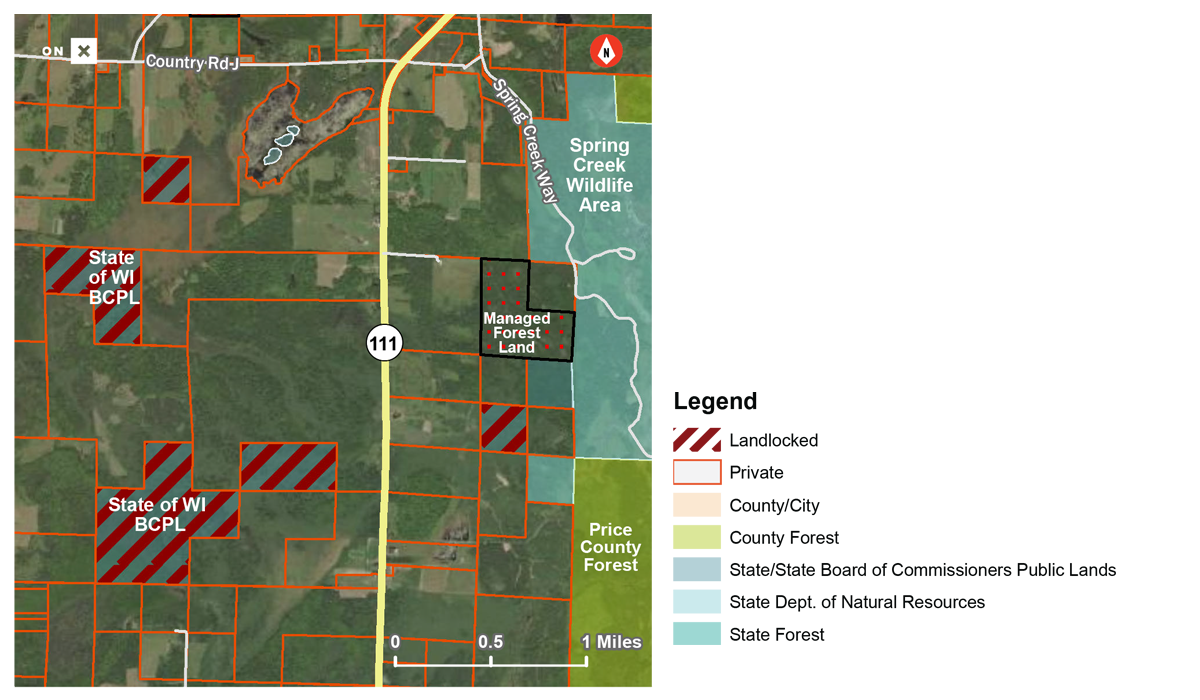
Lay of the Landlocked

Given their history as British colonies, the original thirteen U.S. states were not organized according to the gridded system of ranges, townships, and sections later used to parcel out land ownership in new states and territories as the country expanded westward. As such, property boundaries in states like New York, New Jersey, and Pennsylvania were drawn around geographic features and other landmarks through an early survey system known as “Metes and Bounds.”

Nearly all land in these states became private property during the colonial period through charters granted by the British Crown to corporations or individuals, as well as through the sale of Crown lands. It was only much later that these states—faced with depleted soils, diminishing timber stands, and deteriorating water quality—began actively purchasing lands to address conservation, access, and resource management needs.

The Difference Between East and West

Though they are dwarfed by the sheer land mass of Western states, some Eastern states have accumulated rather large amounts of public land. In New Jersey, the state owns 21 percent of the land within its borders, the third-most of any state behind Alaska and Hawaii. In New York and Pennsylvania, those figures are similarly significant: 14 percent and 13.9 percent respectively, at fifth and sixth place in the nation.

Managed for varying purposes and according to a diverse set of frameworks, public lands in these three states have a rich tradition. New York established the first state park system in 1881 and created the Adirondack Preserve (later Adirondack Park) in subsequent years. New Jersey similarly has its own large, relatively undeveloped, and sparsely populated natural area in the state’s southern Pine Barrens.

Many of the state lands in the region, particularly in New York and Pennsylvania, were formerly abandoned farmlands or private timberlands on which the owners stopped paying property taxes after the parcels were cut over in the late 19th and early 20th centuries. Other lands were acquired by the states to conserve wildlife habitat in the early 20th century. The Pennsylvania Game Commission, for example, manages nearly 1.5 million acres of State Game Lands for this purpose.

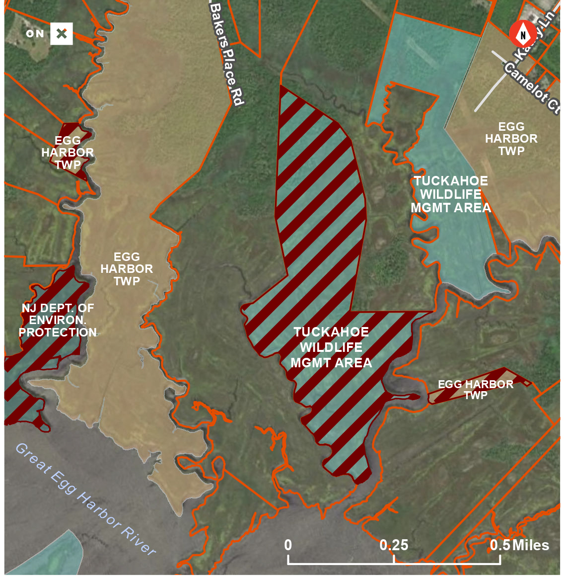
Accordingly, the bulk of the 80,000 acres of landlocked public lands we identified in the Mid-Atlantic are managed by the states, counties, and municipalities. Less than 5 percent of all the landlocked acres we found in this region are managed by federal agencies, compared to about 60 percent in the West.

Another important distinction between East and West, because land ownership boundaries in this part of the country are far less likely to align neatly at corners like a checkerboard, is that “corner-crossing” as a contested form of public access is a much less significant debate in the Mid-Atlantic states. 

That doesn’t diminish the severity of having 80,000 acres of lost hunting and fishing opportunities across the region. There are solutions, but sportsmen and women must be vocal about the resources and legislative initiatives necessary to unlock our public lands.

Dig into more of the landlocked data at unlockingpubliclands.org.

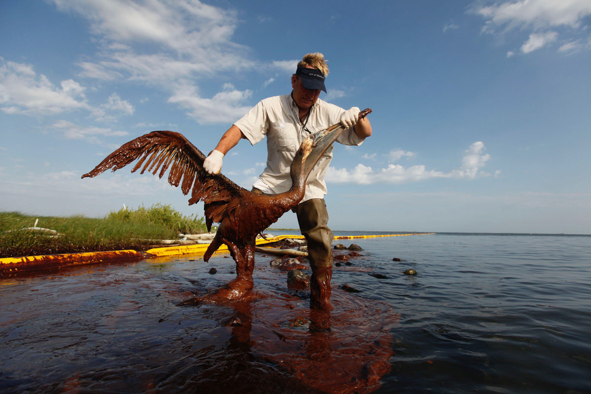
Top photo courtesy of the New York State Department of Environmental Conservation via flickr.

5 Responses to “The Biggest Difference Between Landlocked Public Lands in the East and West”

  1. thomas Dake

    love the info, did not realize that public land was still being landlocked, last time i was working in the clear lake area, there was public access areas that were “closed” by the neighbors this was in the s.w. portion, would /can you ck this out too? keep up the good work thanks tom

    • Kristyn Brady

      We appreciate the opportunity to hear your thoughts, Christine. These are not wilderness areas simply because they’ve become surrounded by private lands. They are owned by federal, state, county, or municipal agencies and some are even managed primarily to generate revenue to fund schools and other institutions. Thanks for reading.

  2. Steve Moore

    I just put a complaint in with DNR in Washington State. They have allowed private land owners to put gate’s everywhere. Which has cut off access to our state public land’s. Which up until the last 10 year’s never had gate’s blocking our access.

Do you have any thoughts on this post?

XHTML: You can use these tags: <a href="" title=""> <abbr title=""> <acronym title=""> <b> <blockquote cite=""> <cite> <code> <del datetime=""> <em> <i> <q cite=""> <s> <strike> <strong>

Comments must be under 1000 characters.

September 4, 2020

The Top 10 Conservation Stories of Summer 2020

It may have been the summer of COVID, but a lot went down in the world of conservation, too—get caught up

If we were to put together a conservationist’s time capsule for the summer of 2020, it would be absolutely jam-packed with everything from state-level wins and place-based battles to habitat-wide threats and milestone achievements that will benefit future generations of hunters and anglers.

Here is what we’ll remember long after the sun has set on summer 2020.

Photo by Kyle Mlynar.
The Great American Outdoors Act Supercharges LWCF

After a decades-long fight to secure permanent authorization and full funding for our most powerful public land conservation tool, the Land and Water Conservation Fund became a household name. And perhaps the Great American Outdoors Act will be too—this legislation finally maxes out the program at $900 million annually to create outdoor recreation opportunities, unlock public land access, and conserve key habitats. It also invests $1.9 billion annually for the next five years to address the maintenance backlog on National Park Service, U.S. Forest Service, U.S. Fish & Wildlife Service, and Bureau of Land Management lands.

Something else to celebrate is how this bill proves that conservation transcends partisanship. There were many issues vying for the attention of our lawmakers this summer, including an economic downturn and unprecedented health crisis, but the Great American Outdoors Act made it through the Senate, House, and a presidential signing ceremony in a matter of months. Your support helped to make this possible.


Photo by Fly Out Media.
A Powerful Pushback on Pebble Mine

Just weeks after concluding in its final environmental impact statement that Pebble Mine would not have a measurable effect on fish numbers and signaling that an approved permit might be coming soon, the U.S. Army Corps of Engineers told developers that the mine could not proceed as proposed. The agency ultimately decided that the project “could have substantial environmental impacts within the unique Bristol Bay watershed.”

Sportsmen and women—not to mention some high-ranking Trump advisors—called directly on the president to intervene and stop Pebble Mine, which would destroy an estimated 185 miles of streams and 4,000 acres of wetlands in Bristol Bay, the most prolific sockeye salmon fishery on the planet. The Corps decision is good news, but there is still work to do to shut down the mining proposal for good.


Image courtesy of Tony Rocheford/USFWS Midwest.
300K Acres of Public Lands in the Midwest Are Inaccessible

In the first of three announcements, the TRCP and onX added to the tally of landlocked public lands we have already identified in the western U.S., this time looking at Minnesota and Wisconsin. Between federal, state, county, and municipal public lands, the two states share more than 300,000 acres with no permanent legal access around or through private lands.

This fall, we’ll announce the results of our research in Pennsylvania, New York, and New Jersey and Arkansas, Florida, Tennessee, and North Carolina. Sign up to be the first to hear about it.


Photo by Tim Donovan/FWC.
The Hunting and Fishing Community Rallies Around #ResponsibleRecreation

After the first major spike in COVID-19 cases, as public lands and some hunting and fishing seasons began reopening, the TRCP joined respected conservation leaders at the National Wild Turkey Federation, Congressional Sportsmen’s Foundation, Ducks Unlimited, Trout Unlimited, Pheasants Forever, and Association of Fish and Wildlife Agencies to launch the #ResponsibleRecreation pledge.

It remains important for Americans to take advantage of our country’s numerous opportunities to recreate on public lands and waters, while maintaining proper social distancing and adhering to other best practices in line with recommendations from the Center for Disease Control and Prevention. You can take the pledge here.


Photo by Gavin Van Wagoner.
Three Threats to Bedrock Conservation Laws

In July, we flagged the EPA’s quiet change to a rule that gave states the right to look out for water quality on federal land within their borders at the permitting phase of new development projects. The agency’s new rule addressed an obscure but important function of the Clean Water Act, which was also rolled back when it comes to protections for headwater streams and wetlands.

Combined with a third threat to bedrock conservation law—proposed changes to the National Environmental Policy Act that would significantly inhibit the ability of federal agencies to measure the impacts of development on habitat—it’s clear that the administration’s newest policies would benefit developers while sportsmen and women lose out.


Photo by David Blinken.
Menhaden Managers Will Consider the Bigger Picture

In a move supported by anglers, the Atlantic States Marine Fisheries Commission voted unanimously in August to improve its management strategy for Atlantic menhaden, the tiny baitfish that supports some of our most popular sportfish, by considering the species’ role in the broader ecosystem. The Commission worked for more than a decade to develop ecological reference points—indicators like the health of predator populations, including striped bass and bluefish, as well as the amount of alternative prey for these sportfish. Ultimately, these reference points can be used to set quotas that will help ensure enough menhaden are left in the water as forage.

Learn more about menhaden management and restoration here.


Outdoor Recreation Businesses Call on Congress to Pass MAPLand Act

A cross-section of the $887-billion outdoor recreation economy—from gear manufacturers and media companies to guides, outfitters, and retailers—sent a letter in July urging lawmakers to pass the Modernizing Access to Our Public Land, or MAPLand, Act. Business owners emphasized that their livelihoods depend on sportsmen and women having access to outdoor recreation opportunities on public lands, and the MAPLand Act would push federal agencies to digitize their paper maps and easement records so more people can find places to recreate.

Support the MAPLand Act here.


One-Third of Congressional Funding for CWD Is Going to Captive Deer Industry

For years, sportsmen and women have called on lawmakers to take meaningful federal action to control chronic wasting disease among our wild deer, elk, and moose populations. In 2020, Congress responded by appropriating $5 million to the U.S. Department of Agriculture to send directly to state wildlife and agricultural departments tasked with responding to the disease.

Instead, the Animal and Plant Health Inspection Service is funneling $1.5 million of that funding to individual captive deer operations that have had to eliminate CWD-positive animals. These indemnification payments aid businesses that have already been part of the CWD problem and don’t address the continued strain placed on state agencies scrambling to manage the spread of the disease.

Join us in pushing back on this misuse of federal funding.


Photo by Louisiana Department of Wildlife and Fisheries.
The Gulf Coast is Rebounding 10 Years After BP Oil Spill

The explosion of the Deepwater Horizon oil rig and the subsequent oil spill in the spring and summer of 2010 was the worst environmental disaster in American history. But in the decade since this tragedy, oil spill penalties have been invested in projects that directly address the damage, improving the outlook for the Gulf of Mexico’s coastal communities and fish and wildlife habitat.

We took an in-depth look at four major projects built or planned using Deepwater Horizon penalties that have directly benefited anglers and hunters by improving coastal habitats.


Photo by Howie Garber
Your Voice Is Powerful in These Backcountry Conservation Efforts

Sportsmen and women in Montana and Alaska—and across the country—took a stand on the future of intact, undeveloped habitats that are important to fish and wildlife.

This summer, the Bureau of Land Management responded to hunter and angler support for these landscapes in Montana by including Backcountry Conservation Areas in two revised resource management plans for approximately 900,000 acres of public lands east of Missoula, surrounding Lewistown, and in and around the Missouri River Breaks.

Backcountry Conservation Areas allow the BLM to prioritize public access and habitat management actions, such as restoring riparian areas and streams, controlling invasive species, managing vegetation, improving fish passages, reducing the risk of wildfires, and increasing forage. There are BCAs proposed across the West.

Hunter and angler voices were also crucial in the fight to keep conservation safeguards for 9.2 million acres of intact and undeveloped habitat in the Tongass National Forest of Alaska. According to data released by the Forest Service this summer, 96 percent of comments from the public support keeping the nation’s Roadless Rule in place to conserve some of the world’s most productive salmon and Sitka blacktail deer habitat.


Top photo by Kyle Mlynar.

August 4, 2020

300K Acres of Public Land in Minnesota and Wisconsin Are Inaccessible

With today’s signing of the Great American Outdoors Act fully funding nation’s most important access program, new report details the extent of inaccessible public lands in the Upper Midwest

The Theodore Roosevelt Conservation Partnership and onX announced today that more than 303,000 acres of public land in Minnesota and Wisconsin are entirely landlocked by private land and, therefore, inaccessible to hunters, anglers, and other outdoor recreationists.

The new report is an expansion of a two-year effort to analyze the amount of landlocked public lands in the Pacific and Intermountain West, which to date has shown that nearly 16 million federal and state acres have no permanent legal access because they are isolated by private lands.

The report’s publication is timely in the wake of one of the biggest conservation wins in recent memory. Just today, President Trump signed into law the Great American Outdoors Act, securing full funding for the Land and Water Conservation Fund, the federal program best suited to improving and expanding outdoor access to public lands across the country.

The Findings

Using today’s leading mapping technologies, the collaborative study found that more than 248,000 acres of public lands in Minnesota and more than 55,000 acres in Wisconsin are landlocked and inaccessible to the public without private landowner permission. The detailed findings are now available in a new report, “The Upper Midwest’s Landlocked Public Lands: Untapped Hunting and Fishing Opportunities in Minnesota and Wisconsin,” which also unpacks the stakes of the problem and its historical roots.

“Through our ongoing collaboration with onX, we have been able to identify parcels of land that belong to taxpayers, yet they are unable to take advantage of the vast outdoor opportunities on these lands,” said Joel Webster, Senior Director of Western Programs at the Theodore Roosevelt Conservation Partnership. “It is our hope that with this information, policymakers can see the problem, identify solutions, and work to ensure that sportsmen and sportswomen can access the lands that belong to them.”

“We know how important public land access opportunities are to hunters and anglers all across the country,” said onX access advocacy manager Lisa Nichols. “Especially in places where the majority of the landscape is privately owned, GPS technologies have enabled outdoor recreationists not only to find new opportunities on public lands, but also to notice landlocked parcels that could offer more of these opportunities if there was a legal way to access them.”

While the analysis looked at public lands managed by different levels of government—including federal, state, county, and municipal—the majority of landlocked acres in both Minnesota and Wisconsin were state lands, followed by combined county/municipal acres. Ranging in size from just a few acres to nearly 4,000 acres, the landlocked acres identified by the project could potentially offer outdoor recreationists in the region new opportunities to get outdoors both in urban and rural areas.

“When it comes to landlocked public lands, even small access projects can make a big difference,” adds Nichols. “Finding collaborative solutions to open some of these lands could offer new opportunities to residents of nearby communities where access to public lands and waters might currently be limited.”

Improved public access is also a driver of the $778 billion outdoor recreation economy. Leading brands in the hunting and fishing industry have long recognized the importance of public lands to their customers and their businesses.

“As a family owned, American sports optics company that is based in Wisconsin, we personally understand the value that public lands provide to our customers and employees for outdoor recreation,” said Paul Neess, conservation/education support specialist with Vortex Optics of Barneveld, Wisconsin. “Landlocked public lands in our state and any other state represent missed days and lost opportunities afield for sportsmen and women, and we support all cooperative efforts to open these lands to the public as they were intended to be.”

The Solutions

With the recent passage of the bipartisan Great American Outdoors Act, the Land and Water Conservation Fund will now provide a guaranteed $27 million in annual federal funding for public access work. Additionally, at least 40 percent of the program’s overall $900 million budget must be used for state-driven projects.

The onX-TRCP report further highlights several important programs in Minnesota and Wisconsin that help to create new access for public land users.

Wisconsin’s Knowles-Nelson Stewardship Program funds efforts to conserve habitat and water quality, and also prioritizes expanding opportunities for outdoor recreation. Significantly, the program is set to expire in 2022 unless state lawmakers act to renew the program. Given the program’s 2019 budget of $33 million, its expiration could result in lost or reduced opportunities to expand access in Wisconsin.

Established in 2008, Minnesota’s Lessard Sams Outdoor Heritage Fund supports projects that protect, enhance, or restore prairies, wetlands, forests, or other habitat, and—when it meets those primary goals—can also be used to open or expand access to inaccessible wildlife management areas managed by Minnesota DNR’s Fish and Wildlife Division.

“Pheasants Forever is actively working to unlock access to public lands across western Minnesota and in other areas of the Midwest, which translates to increased and improved hunting opportunities,” said Eran Sandquist, Minnesota state coordinator with Pheasants Forever. “We work with partners like Minnesota’s Lessard Sams Outdoor Heritage Council to not only conserve wildlife habitat, but also to expand public access, so more sportsmen and women can enjoy quality days afield.”

Additionally, the Minnesota Department of Natural Resources’ Strategic Land Asset Management program ensures that the state’s public land holdings reflect its conservation, recreation, and economic values and needs. In an ongoing evaluation process, proposed land acquisitions are measured according to the program’s priorities, including increasing access to public lands.

“In Minnesota, we are very proud of our Strategic Land Asset Management (SLAM) Program and the SLAM framework we have built to ensure public access is evaluated and prioritized on an on-going basis,” said Trina Zieman, the Minnesota DNR’s land asset and school trust administrator. “We appreciate the work done by this collaborative to bring awareness to this issue and identify options that will continue to unlock our public lands for generations of recreationalists.”

Given the level of interest from the public, support from the outdoor industry, and the commitment of state and federal agencies, conservation groups like the TRCP anticipate a bright future for improved and expanded public land access.

“Both states featured in this project have innovative programs for conserving habitat and improving access for hunting and fishing,” said TRCP’s Webster. “It’s our hope that this report highlights the importance of this work to decision makers and the public, especially given the positive effects that it has for families, communities, businesses, and the future of outdoor recreation”

A companion website, unlockingpubliclands.org, unpacks the issue in more detail and provides links to additional information about landlocked public lands. Visitors to the site can download the report as well as the previous reports published by onX and TRCP in 2018 and 2019.

Earlier this year, onX also launched a new crowd-sourcing initiative, Report a Land Access Opportunity, with the help of partners including TRCP. The program provides the public with a platform to share on-the-ground knowledge about locations where access to outdoor recreation has been threatened or could be improved. The information received by onX is then provided to the relevant nonprofits and land management agencies that can help.


Top photo: The Hunting Public

August 3, 2020

How Midwestern Public Lands Were Landlocked by History

Just like in the West, the history of how lands changed hands has contributed to today’s public access challenges

In the media and in popular imagination, public lands are most closely associated with Western snowcapped peaks managed by the U.S. Forest Service and National Park Service or vast expanses of sagebrush prairie managed by the Bureau of Land Management.

But places like the Superior National Forest in Minnesota offer as much of a chance to immerse oneself in adventure as any of the public lands in the West. And for Midwestern hunters and anglers, there are millions of acres of state, county, and locally managed lands that provide critical access close to home.

There are also as many as 300,000 acres of public lands in Minnesota and Wisconsin that are completely surrounded by private land, according to our latest report in partnership with onX. These lands represent lost hunting and fishing opportunities and a national challenge that is unfortunately becoming all too familiar—they’re your public lands, but you can’t get to them without asking someone’s permission.

So how did these public lands become landlocked?

As with other states in the West and Midwest, upon statehood the land base in Minnesota and Wisconsin was organized into six-by-six-mile squares known as townships according to the Public Land Survey System. Each township was further divided into 36 individual one-mile-square (640-acre) sections.

Both states received land grants from the federal government, originally comprised of two sections within each township, which were to be used to support public schools. Following statehood, several subsequent conveyances of federal land were provided to Minnesota and Wisconsin to serve various purposes, such as to support additional state institutions, create state parks and forests, expand agriculture, and retire marginal or unproductive farmland during the Great Depression. Meanwhile, millions of acres reverted back to counties and the states due in part to tax forfeiture.

Later, the Department of Natural Resources in each state began actively purchasing lands to meet management needs, generate revenue, protect critical fish and wildlife habitats, and provide access for sportsmen and women.

There were also vast federal public lands set aside in the Northwoods in the early 20th century, including the Chippewa and Superior National Forests in Minnesota and the Chequamegon-Nicolet National Forest in Wisconsin.

The result today is some of the most diverse public land holdings found anywhere in the nation and, unfortunately, a remnant patchwork of landlocked public lands.

Click here to read about three programs that offer solutions to the landlocked problem in the Midwest.

Take action and dig into the data on the 16.17 million acres of landlocked lands we’ve identified across 15 U.S. states.

VISIT UNLOCKINGPUBLICLANDS.ORG


Top photo by Joe D via flickr.

Three Ways to Unlock the Midwest’s Inaccessible Public Lands

These programs could serve as a model for other states with a growing tally of landlocked hunting and fishing areas

These days, thanks to GPS technology, anyone with a smartphone can take advantage of the hunting and fishing opportunities offered by even the smallest parcel of public lands. But what if you stumble across something like this, where there doesn’t seem to be any legal access to reach it?

You might think it’s a mistake, but there are actually more than 300,000 acres of these landlocked public lands in Minnesota and Wisconsin alone. Across the West, there are nearly 16 million landlocked acres.

Sure, you could knock on a few doors and request permission to cross private land into those crosshatched areas. But if access to public lands like these remains exclusive or temporary, we’re tying one hand behind our backs when it comes to recruiting and retaining the participation of new hunters and anglers.

For a Midwestern hunter looking to hang a treestand for whitetails, set up an ambush for turkeys, or work a woodlot for grouse—especially for the first time—a small or overlooked public parcel could be a game-changer. And easy access to a lake shore or riverbank might give a parent the only place they’re be able to teach their kids to fish for walleye, pike, or smallmouth bass.

Strategically unlocking as little as a few dozen inaccessible acres at a time could mean the difference between a young person having a place to hunt or not. A lifelong passion for fishing—and the conservation funding raised by those license purchases—could hang in the balance.

So how are Midwestern states unlocking inaccessible public lands?

Landlocked public lands are best made accessible through cooperative agreements with private landowners that result in land exchanges, acquisitions, and easements, but this critical work cannot be facilitated by land trusts, conservation organizations, and public agencies without funding.

When thinking about opening inaccessible public lands, even small projects can offer big benefits. Here are three programs that support these efforts.

The Land and Water Conservation Fund

The federal LWCF remains the most powerful tool available for establishing and expanding access to public lands and waters. And it just got more powerful, with the recent passage of the Great American Outdoors Act, a bill that fully funds the program at $900 million annually in support of wildlife conservation and outdoor recreation, including $27 million that is dedicated to public access. Importantly, the LWCF is not just limited to federal projects—at least 40 percent of the program must be used for state-driven projects, making it available to help open state- and county-owned lands for public recreation.

Minnesota’s Lessard Sams Outdoor Heritage Fund

Established by the voters of Minnesota in 2008, the Outdoor Heritage Fund is supported through the state sales tax. This program empowers projects that protect, enhance, or restore prairies, wetlands, forests, or other habitat, and—when it meets those primary goals—can also be used to open or expand access to inaccessible wildlife management areas managed by Minnesota DNR’s Fish and Wildlife Division. With an estimated $100 million available in 2022, the Outdoor Heritage Fund is a heavy hitter in support of conservation and access.

Wisconsin’s Knowles Nelson Stewardship Program

Created in 1989, this program exists to preserve valuable natural areas and wildlife habitat, protect water quality and fisheries, and expand opportunities for outdoor recreation. With a budget of $33 million in 2019, Knowles Nelson is a major program that, among other things, can help unlock Wisconsin’s state parks, wildlife and fisheries areas and state natural areas. Knowles Nelson is set to expire in 2022 and will need to be renewed by the state legislature. State decision makers need to know the importance of this program for wildlife habitat and public access.

What Sportsmen and Women Can Do

Both Minnesota and Wisconsin have innovative state programs for conserving habitat and improving access that should serve as valuable models for other states looking to do the same. Support local ballot initiatives and state legislation to set aside these dedicated funds where you live.

To ensure the best possible use of the LWCF for unlocking inaccessible public lands, take action here.

SUPPORT THE MAPLAND ACT

To dig into the data we’ve uncovered on inaccessible public lands across the country, click here.

HOW YOU CAN HELP

CHEERS TO CONSERVATION

Theodore Roosevelt’s experiences hunting and fishing certainly fueled his passion for conservation, but it seems that a passion for coffee may have powered his mornings. In fact, Roosevelt’s son once said that his father’s coffee cup was “more in the nature of a bathtub.” TRCP has partnered with Afuera Coffee Co. to bring together his two loves: a strong morning brew and a dedication to conservation. With your purchase, you’ll not only enjoy waking up to the rich aroma of this bolder roast—you’ll be supporting the important work of preserving hunting and fishing opportunities for all.

Learn More
Subscribe

You have Successfully Subscribed!

You have Successfully Subscribed!

You have Successfully Subscribed!

You have Successfully Subscribed!

You have Successfully Subscribed!