Comment Now – Help Land Management Agencies Open Access to Your Public Lands
BLM, USFS, and USFWS seek nominations from the public for high-priority landlocked or hard-to-reach parcels
Last spring, with the passage of S. 47 – the John D. Dingell, Jr. Conservation, Management, and Recreation Act – federal public land management agencies were tasked with identifying parcels of public ground with no access or restricted access and developing priority lists for opening access to those lands.
Now, the US Forest Service, BLM, and US Fish and Wildlife Service are asking the public for help to identify pieces of public land that should be on the priority lists. This is your chance to get involved and make a difference.
Once parcels are added to an agency’s priority list, land managers can then coordinate with state and local governments, conservation groups, land trusts, and landowners to open access through voluntary acquisitions of land, road or trail easements, or various other measures.
As our partnership with onX has shown, access to public land can be a huge challenge for hunters and anglers. We found that 9.52 million acres of federally managed public lands in the West have no permanent, legal public access.
Details on how to nominate a parcel are below, but time is running out. Speak up today to strengthen our public lands legacy!
Lawmakers have outlined the below requirements for the agencies:
Parcels nominated must encompass at least 640 contiguous acres with either no public access (i.e. it is unreachable by foot, horseback, and motorized/non-motorized vehicles) or the access is severely restricted (i.e. a large block of public land with only one access point).
In order to be considered, nominations must be sent to the appropriate agency (i.e. the agency responsible for managing the lands in question).
Nominations must include the location of the land or parcel, the total affected acreage (if known), a description or narrative about the barriers to access, and any other information that should be considered by the agency.
Forest Service: Comment period has closed.
Fish and Wildlife Service: Comment period has closed.
BLM: Comment period has closed.
7 Responses to “Comment Now – Help Land Management Agencies Open Access to Your Public Lands”
Charles Haywood
Hope they open all access to the millions of now landlocked public lands nation wide. I nominate blocked rd access by land developer Steve Massey in Gunnison, CO. Off of rd 26. It’s been closed now for 4 plus years. It gives access to the south side of Blue Mesa dam. Another rd closed by outfitters is east of lone cone out if Norwood. There is no penalty for people who block access and no easy legal path to stop this from happening. Your on the right track. As far as the rd closure in Gunnison south of Blue Mesa, the CPW the NPS also want it opened up.
Like pretty much everyone here, i strongly support access to public lands and waters, whether it be for hunting & fishing or hiking and birding. In fact, it’s a big part of what I do for a living. That being said, it’s clear that in some cases, some species do much better without humans around. Such “breathing room” is certainly best for T&E species like Black-footed ferret as well as others that have yet to adapt to a greater human presence (like Red-tailed Hawks for instance). I’m also concerned about the possibility of increased off-road vehicle use other than that done by “sports”. (How’s THAT for bringing back a 100+ year old term that’s also gender-inclusive?). In addition, making things easier for timber cruisers, oil, gas & mining speculators could be another unexpected consequence. I’m just saying we need to be smart, use all available good science and put guarantees in place that will safeguard both the habitats and proper access to them. And if some places ought truly to be left alone for the benefit of wildlife, so be it..
Can somebody please contact me from this organization , I have been fighting side by side with game and fish on this very topic for years in Arizona , I know of hundreds of thousands of public state land that has some serious issues . I’ve needed to find something like this to help voice what I see In the woods and I spend ALOT of time in the woods . I have a ton of info and knowledge on the topic . My phone number is 928 899 7037 and I look forward to hearing from someone .
I nominated a few select parcels. These are PUBLIC lands but completely exclude public access. This only benefits the landowner who can treat these landlocked parcels as their own but don’t have to deal with the taxes or liability…
TRCP Recognizes Governor Gordon’s Leadership in Executive Order on Migration Corridors
Stresses need for long-term commitment to see the conservation of vital big-game habitats
Wyoming Governor Mark Gordon signed an executive order this week prioritizing the conservation of big-game migration corridors.
The TRCP responded to the directive:
“We appreciate Governor Gordon’s leadership on big-game migration corridors with his Executive Order,” said Nick Dobric, Wyoming field representative with the Theodore Roosevelt Conservation Partnership. “We have incredible wildlife populations and hunting opportunities in Wyoming, and we hope that the Governor’s directives will help conserve these resources for decades and generations to come.”
During the summer of 2019, Governor Gordon tasked an advisory group of eight citizens—each representing various interests, including sportsmen—with devising a solution for migration corridors that would conserve the corridors while being consistent with multiple uses of the land. After three long sessions, the group recommended the governor could best address the issue through an executive order that would set up a process for more public involvement and limit development in designated corridors, with emphasis on stopover and high-use areas.
Subdivisions, fences, roads, and energy development all contribute to the loss of big-game habitat and impede the migrations of these animals between the seasonal habitats on which they rely. Land-use planning decisions on state and federal lands can have a determinative effect on the function of these habitats. This includes the proposed management objectives in the Rock Springs draft Resource Management Plan that is expected this Spring and will have implications for the Sublette Mule Deer herd, which depends upon the 150-mile migration corridor commonly known as the Red Desert to Hoback.
“This week’s action should be viewed as a renewed commitment, not a final step, to see migration corridors conserved over the long-term in Wyoming. Sportsmen are hopeful that the governor’s directives will be applied to the Rock Springs draft RMP, which overlaps with the designated Sublette corridor,” said Dobric. “We are counting on the BLM to support state management objectives for this deer herd and apply conservation measures that protect its future.”
Many of Wyoming’s big game herds depend on migration corridors in areas that have yet to be formally identified and designated. While the Order does not apply to areas outside of designated corridors, the science does support similar measures to conserve habitats and allow for multiple uses in other areas. Wyoming Game and Fish has been at the forefront in the West due to their efforts to gather the best science to inform their big game management. Years of captures and collaring, funded by sportsmen and others, gives the state a strong foundation for expanding its efforts so that conservation measures can be put into practice on the ground for migrating big game.
“Wyoming has been a leader of migration science, as well as the policy, for over a decade,” said Dobric. “The TRCP will continue to work with the Governor, state and federal agencies, sportsmen, and other stakeholders to implement this Order and ensure the continued functionality of big-game migration corridors.”
Four Rivers BLM Land Use Plan Revised to Address Priorities of Hunters and Anglers
Final plan includes key provisions to benefit wildlife habitat and outdoor recreation
The Bureau of Land Management today released a land use plan that will support outdoor recreation opportunities and conserve important big game habitat on public lands north of Mountain Home and east of Boise in western Idaho.
When finalized, the BLM’s proposed Resource Management Plan for the Four Rivers Field Office will determine how the agency will manage approximately 750,000 acres of public lands, including the Boise Front, the eastern flanks of Brownlee and Oxbow reservoirs, and the Hixon Sharptailed Grouse Area.
The Theodore Roosevelt Conservation Partnership worked with landowners, local government officials, and other stakeholder groups, and helped activate hunters and anglers to provide meaningful feedback on the draft plans that was then incorporated into the final proposals.
“Sportsmen and women spoke up in support of additional management emphasis for hunting, access, and habitat improvement under the final plan, and we appreciate that the BLM listened to our community’s requests,” said Rob Thornberry, Idaho Field Representative with the Theodore Roosevelt Conservation Partnership. “This plan will benefit quality wildlife habitat and recreational access in places like the Bennett Hills, which is great news for those of us who care about Idaho’s strong outdoor traditions.”
The popular public lands in central and western Idaho to which the revised plan will apply help fuel the state’s $7.8-billion outdoor recreation economy, provide important wildlife habitat, and support various traditional uses of the land. These landscapes include IDFG Hunting Units 39, 43, 44, and 45, which offer some of the state’s best mule deer hunting.
“The Bennett Hills provide vital winter range and outstanding hunting opportunities for one of Idaho’s most important mule deer herds,” said Ford Van Fossen, conservation and content manager for First Lite, a Ketchum-based manufacturer of hunting apparel. “We want to thank the BLM for adopting measures in the Four Rivers RMP that prioritize wildlife habitat and outdoor recreation.”
The revision process was formally initiated with a scoping phase in early 2016 and the BLM published its draft plan with a number of proposed alternatives in May 2019. While several wildlife- and recreation-friendly provisions to improve access and habitat were considered in the draft plan, most were not included in the preferred alternative at that stage of the process. Hunters and anglers spoke up and requested changes in management, and those comments produced meaningful improvements to the proposed plan.
“The hunting and fishing community owes the BLM thanks for the agency’s responsiveness to our concerns and proposals,” Thornberry said. “Public lands in Idaho are some of our state’s greatest assets and the revised Four Rivers plan will help ensure that future generations can enjoy these places as we do now.”
“I have hunted this area for almost 50 years, and I can state emphatically that it is a haven for an enormous amount of wildlife,” said Drew Wahlin, president of the Idaho Chukar Foundation. “It is a bird hunting destination and an essential winter area for the famed King Hill mule deer hunt. It is worthy of protections that help wildlife and sportsmen, and I applaud BLM’s decision.”
Sportsmen and Women Support Missoula and Lewistown BLM Land Use Plans
Wildlife habitat and outdoor recreation will benefit from final revisions
The Bureau of Land Management today released land use plans that will support outdoor recreation opportunities and habitat for big game near Missoula and northeast of Lewistown, in and around the Missouri River Breaks.
When finalized, the BLM’s proposed Resource Management Plans for the Missoula and Lewistown Field Offices will determine the future of forest and grassland management, wildlife habitat, and outdoor recreation on approximately 900,000 acres of public lands in western and central Montana.
The Theodore Roosevelt Conservation Partnership worked with landowners, local government officials, and other stakeholder groups, and helped activate sportsmen and women to provide meaningful feedback on the draft plans that were then incorporated into the final proposals.
“We appreciate that the BLM listened to the input of the hunting and fishing community during the draft comment periods for both the Missoula and Lewistown RMPs, and made meaningful refinements to benefit quality wildlife habitat and recreational access,” said Scott Laird, Montana Field Representative with the Theodore Roosevelt Conservation Partnership. “Places like the Hoodoos and Ram Mountain in the Missoula area, as well as Arrow Creek and Crooked Creek in central Montana, will receive additional management emphasis for hunting, access, and habitat improvement under the final plans, and we view that as positive for sportsmen and women.”
The Missoula plan will guide management of local landmarks including the Blackfoot River corridor and portions of the Garnet and John Long mountain ranges. The revision process was formally initiated in early 2016 with a scoping phase and the draft plan was published in May 2019. While several wildlife- and recreation-friendly management measures dealing with access and habitat management were considered in the draft plan, they were generally not included in the preferred alternative at that stage of the process. Hunters, anglers, the state of Montana, tribal representatives, Missoula County, and other entities spoke up in support of such provisions, and those comments were reflected through meaningful changes in the final plan, including through the adoption of Backcountry Conservation Areas, a multiple-use focused conservation management tool.
“It is encouraging to see the BLM’s responsiveness to the concerns and suggestions of our community,” said Missoula County Commissioner Dave Strohmaier. “We’re fortunate to have these publicly owned landscapes in our own backyard and the revised plan will help ensure that future generations can enjoy them as we do now.”
“Having access to high-quality hunting opportunities on our public lands is critical for our customers and our bottom line,” said Casey Smith, owner of Straight 6 Archery in Missoula. “Refinements made to the BLM’s Missoula plan will help safeguard our outdoor traditions.”
In the Lewistown Field Office, which encompasses some of Montana’s best elk hunting units in the Missouri River Breaks, the planning revision process unfolded along a parallel timeline to that in Missoula. Similarly, strong support from the sporting community, the state of Montana, and local conservation groups led BLM decision-makers to include wildlife- and recreation-friendly measures in the final plan.
“The knowledge that places like Arrow Creek and Crooked Creek will continue to offer some of the best elk hunting in Montana is excellent news for sportsmen and women across our state,” said Doug Krings, Region 4 Leader for the Montana Chapter of Backcountry Hunters & Anglers. “The BLM made sure that local values and priorities would shape the outcome of this process. As a result, our public land hunting heritage is stronger and future generations of public land owners will enjoy these places.”
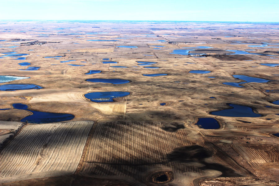
Who Will Protect Our Nation’s Wetlands and Streams Now?
A look back at why EPA’s rollback doesn’t hold water
In January, the administration released its final new rule establishing the reach of the Clean Water Act. If this rule survives court challenges, the landmark federal law protecting our nation’s water from polluting activities will cover fewer waterbodies than at any time since 1972.
The new rule will not safeguard wetlands unless they are adjacent to a river, removing protections for the many wetlands supplied by underground source water, such as the prairie potholes of the upper Midwest, high mountain fens, and the playas of the southern plains. The new rule will also not protect “ephemeral” streams, which flow only after rainstorms.
The 1972 Clean Water Act responded to catastrophic pollution in the 1950s and 1960s, like the Cuyahoga River burning and Lake Erie being declared “dead.” The law replaced a 1965 federal statute that had given states the lead in fighting water pollution. While states are closer to problems and know the local value of a waterbody better than a federal agency in Washington, D.C., states simply did not have the resources or political will to stop the powerful interests responsible for the most damaging pollution.
So, Congress imposed a comprehensive framework to clean up America’s waters. The newly created Environmental Protection Agency and the U.S. Army Corps of Engineers became the first line of defense by policing activities that discharged pollutants to rivers, streams and wetlands, although states were given the option to assume these permit programs if they could demonstrate they had the resources to do so. Meanwhile, states continue to set water quality standards, subject to federal approval, for their rivers, streams, and lakes, while the EPA established nation-wide “technology” standards on an industry-by-industry basis.
Finally, to ensure all parties had incentives to work towards better water quality, Congress appropriated billions of dollars to states for revolving funds to make loans to local governments for the construction of modern wastewater treatment facilities.
Over the decades, this strategy proved spectacularly effective. Our waters are substantially cleaner that in 1970 thanks to the Clean Water Act.
To be sure, every state still has its list of “impaired” waters, most of which are polluted by runoff from agriculture, abandoned mines, or urban development. The law requires states to adopt plans that move these waters towards better quality. Congress provides Section 319 funding to incentivize the implementation of measures that can minimize or eliminate polluted runoff.
Why is this history important? EPA and the Corps of Engineers argue that their decision to stop protecting many streams and over half of the country’s remaining wetlands is justified because states can and should have this responsibility. They assert this rationale while acknowledging that states currently have neither the programs nor the funds to protect all these waters, especially without the substantial federal investment of the last 48 years.
The federal agencies claim that if these water resources are truly important, states will pass legislation to create new programs and impose the new taxes or fees needed to support them, so that they protect their no-longer federally protected waters and wetlands. And if states don’t, then too bad.
“Too bad” is not responsible clean water policy. Congress acted in 1972 for a reason.
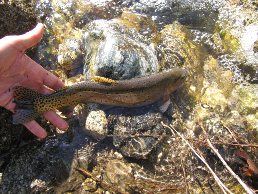
The EPA’s rollback gives the nation a choice: do we really want to lose the clean water gains of the last half century, standing by as activities pollute or destroy the wetlands that support the country’s waterfowl, the headwaters streams that nurture our trout and salmon, and the desert washes that sustain entire communities?
If not, hunters, anglers, and everyone who values these precious water resources will need to organize a massive grassroots campaign. Either we must convince Congress to clarify that the Clean Water Act is intended to protect these water resources or—if Congress refuses to act—we must work to ensure all 50 states have the resources and political will to take over this awesome responsibility.
Theodore Roosevelt’s experiences hunting and fishing certainly fueled his passion for conservation, but it seems that a passion for coffee may have powered his mornings. In fact, Roosevelt’s son once said that his father’s coffee cup was “more in the nature of a bathtub.” TRCP has partnered with Afuera Coffee Co. to bring together his two loves: a strong morning brew and a dedication to conservation. With your purchase, you’ll not only enjoy waking up to the rich aroma of this bolder roast—you’ll be supporting the important work of preserving hunting and fishing opportunities for all.


Hope they open all access to the millions of now landlocked public lands nation wide. I nominate blocked rd access by land developer Steve Massey in Gunnison, CO. Off of rd 26. It’s been closed now for 4 plus years. It gives access to the south side of Blue Mesa dam. Another rd closed by outfitters is east of lone cone out if Norwood. There is no penalty for people who block access and no easy legal path to stop this from happening. Your on the right track. As far as the rd closure in Gunnison south of Blue Mesa, the CPW the NPS also want it opened up.
Please help save our lands, save our wildlife!
Like pretty much everyone here, i strongly support access to public lands and waters, whether it be for hunting & fishing or hiking and birding. In fact, it’s a big part of what I do for a living. That being said, it’s clear that in some cases, some species do much better without humans around. Such “breathing room” is certainly best for T&E species like Black-footed ferret as well as others that have yet to adapt to a greater human presence (like Red-tailed Hawks for instance). I’m also concerned about the possibility of increased off-road vehicle use other than that done by “sports”. (How’s THAT for bringing back a 100+ year old term that’s also gender-inclusive?). In addition, making things easier for timber cruisers, oil, gas & mining speculators could be another unexpected consequence. I’m just saying we need to be smart, use all available good science and put guarantees in place that will safeguard both the habitats and proper access to them. And if some places ought truly to be left alone for the benefit of wildlife, so be it..
Can somebody please contact me from this organization , I have been fighting side by side with game and fish on this very topic for years in Arizona , I know of hundreds of thousands of public state land that has some serious issues . I’ve needed to find something like this to help voice what I see In the woods and I spend ALOT of time in the woods . I have a ton of info and knowledge on the topic . My phone number is 928 899 7037 and I look forward to hearing from someone .
I nominated a few select parcels. These are PUBLIC lands but completely exclude public access. This only benefits the landowner who can treat these landlocked parcels as their own but don’t have to deal with the taxes or liability…
If you need any help in oregon I would be interested in a phone interview. Thanks
If we lose access to public lands we become the Europe our forefathers ran from.