An effort by the Angler Action Foundation and the state of Florida to restore essential fish habitat in southwest Florida will pay dividends for the health of its coast and the Everglades
Every coastal angler worth his or her salt is familiar with the importance of sea grass beds. Sea grass meadows are great places to target species like speckled sea trout from spring through fall. Up to 70% of the species desired by anglers, including tarpon, grouper, redfish, and many more, spend some part of their life cycle in this habitat.
It is estimated that healthy sea grass beds contribute more than $20 billion a year to the Florida economy by providing habitat for commercial and sport fisheries, reducing erosion and impacts of storm events, while also sequestering carbon at a rate of 1,200 lbs/year. By any measure, healthy sea grass meadows play an critical ecological and economic role in Florida and around the world. No surprise then, that the significant loss of sea grass beds in coastal Florida has been a serious concern for many.
The Caloosahatchee Estuary on Florida’s southwest coast has suffered from poor water quality. In addition, increased salinity levels followed by rapid fluctuations in salinity over sustained periods resulted in the loss of up to 1,200 acres of sea grass beds. Major losses occurred some 15 years ago from which the sea grass has been unable to recover on its own.
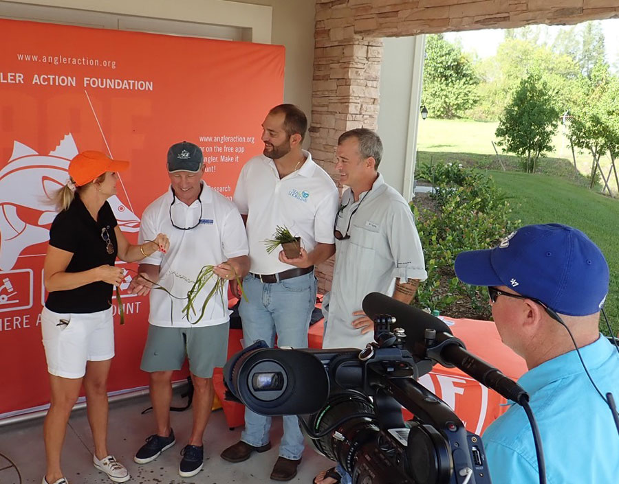
An ambitious project began in 2018 under the direction of the Angler Action Foundation. AAF’s mission is to improve angler access, fisheries science, and marine habitat through collaborative research, education, and conservation programs. Funding for the first phase of the work was provided by Florida’s Department of Environmental Protection, and the leadership of State Senator Kathleen Passidomo and State Representative Heather Fitzenhagen were key to seeing the project receive the necessary support.
Restoration specialists at Sea and Shoreline based in Ruskin, Florida, have led the effort and a third-party ecological assessment of the project is being managed by Johnson Engineering in Fort Meyers and Florida Gulf Coast University.
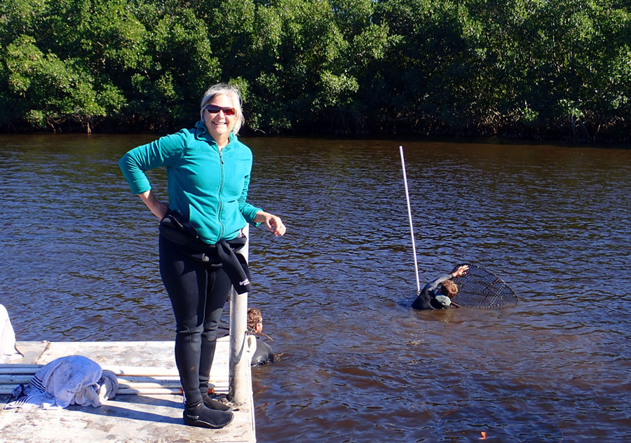
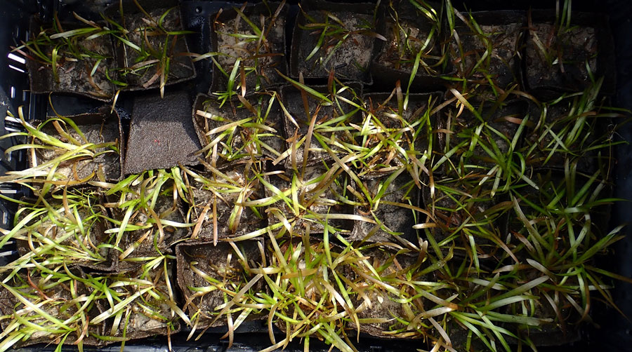
In late 2018, approximately 20 acres of tape grass and widgeon grass were planted in areas that had been decimated by excessive freshwater releases from Lake Okeechobee. Widgeon grass was selected for its ability to pioneer new habitat and tolerate a wide range of salinity. Tape grass, also known as eelgrass or wild celery, is more tolerant of freshwater than other grasses. Planting these two species will provide some insurance that sea grass beds will establish themselves and remain intact under widely varying salinity levels.
Sea grass plantings were protected by wire-mesh exclosures to protect them form turtles and manatees, thus allowing the plants to take root. Initial surveys indicate very high survival rate, with up to 95% of the plantings thriving and producing seeds and rhizomes that will disperse and hopefully establish themselves in adjacent areas, resulting in a self sustaining sea grass meadow.
Future plans are to expand the footprint of the planted areas and continue to monitor the project’s progress. It is hoped the same methods can be used in other parts of Florida such as the Indian River Lagoon, which has also suffered devastating losses of sea grass habitat.
All in all, the Caloosahatchee planting project promises to reverse one of the more serious threats to Florida’s coastal health and is a key part of restoring the Everglades. Anglers should be encouraged that returning sea grass meadows will ensure that sea trout, tarpon, and redfish populations remain strong for future generations of sportsmen and women.
All photos courtesy of Sea and Shoreline
2 Responses to “Sea Grass is the Key”
David W Ceilley
The article is very nice but failed to mention some key partners who did all of the groundwork and several pilot research studies between 2002 and 2018. These partners include Johnson Engineering and Florida Gulf Coast University and they continue to work on this project by monitoring the ecological response of fishes, invertebrates and growth of Vallisneria americana outside of the exclosures.
Having fished the Indian River Lagoon for the past 30 years, I have seen the loss of sea grass habitat and reduced fishing opportunities caused by that loss. However, the problem goes deeper than changes in salinity. An overload of nutrients from development, municipal sewage and agricultural sources led to the brown tide that killed off the sea grass and the remaining game fish in the Lagoon.
Conservation Groups Call on U.S. House to Pass ACE Act
The bipartisan legislation will address growing challenges to species and habitat health
More than 50 conservation groups are banding together and calling on the U.S. House of Representatives to pass bipartisan legislation that invests in wetlands, fisheries, chronic wasting disease research, and the Chesapeake Bay.
In early January, the Senate passed the America’s Conservation Enhancement Act or ACE Act (H.R. 925), and now a coalition of hunting, fishing, and outdoor recreation groups are asking the House to follow suit.
“Passage of the America’s Conservation Enhancement Act will not only have wide-ranging ecological benefits but will facilitate outdoor recreation on behalf of millions of Americans, strengthening conservation funding streams for years to come,” said the groups.
The coalition is asking the House to take up the legislation as passed by the Senate and make no changes.
The ACE Act:
Reauthorizes the North American Wetlands Conservation Act at $60M annually through Fiscal Year 2025. The Act has improved over 30 million acres of wetlands, making it one of the nation’s most effective voluntary conservation programs.
Establishes a U.S. Fish & Wildlife Service-led task force to address the spread of chronic wasting disease.
Codifies the National Fish Habitat Partnership. Since 2006, the Partnership has overseen over 840 projects to benefit fish habitat and populations.
Reauthorizes the Chesapeake Bay Program at $90M through Fiscal Year 2025.
The coalition’s letter to the House is available HERE.
Sportsmen and Women: Rolling Back Clean Water Act Will Harm Habitat
EPA undermines protections for wetlands and streams
The head of the Environmental Protection Agency today announced a final decision to redefine which waters are eligible for Clean Water Act protections, leaving important habitat for fish and waterfowl vulnerable to pollution and significant harm.
Speaking at the National Association of Home Builders conference, Administrator Andrew Wheeler said he would be rolling back the 2015 Clean Water rule.
“This announcement flies in the face of all the hunters and fishermen who have contacted the EPA saying they oppose this decision,” said Whit Fosburgh, president and CEO of the Theodore Roosevelt Conservation Partnership. “These rollbacks undermine the intent of the Clean Water Act, which has a proven track record of protecting America’s waters and supporting healthy habitat.”
The new rule will leave roughly half of the nation’s wetlands and almost one out of five of its stream miles without federal protection from pollution. In drier western states, as many of 90 percent of stream miles will not be protected from being polluted.
Congress passed the Clean Water Act in 1972, creating a federal regulatory floor for pollution control across the country, as well as a partnership with states to address the many threats to our nation’s waters. This was important because states had not had the financial or political resources necessary to ensure clean water. Now the EPA and the Army Corps of Engineers are asserting that for all of the streams and wetlands they will no longer protect, states could step in, if they want, even as the agencies acknowledge that many states won’t have the resources to do so.
In a national poll, 93 percent of hunters and anglers say they believe the Clean Water Act has benefited the country. Additionally, 80 percent of sportsmen and women said Clean Water Act protections should apply to headwater streams and wetlands. Additionally, 92 percent believe that we should strengthen or maintain current clean water standards, not relax them.
Sportsmen for the Rubies Supports Bill to Curb Speculative Oil and Gas Leasing
Nevada sportsmen today voiced support for legislation that ensures responsible energy development on public land.
The End Speculative Oil and Gas Leasing Act of 2020 S.3202) introduced by Sen. Catherine Cortez Masto (D-Nev.), would require the Bureau of Land Management (BLM) to not lease lands that have little or no potential for the development of oil and gas reserves. The legislation would apply to all federal lands across the West, specifically to lands that are considered low or no potential for oil and gas development.
Sen. Cortez Masto is also sponsoring a separate bill, the Ruby Mountain Protection Act (S.258), which would prevent speculative leasing in one of Nevada’s most revered hunting, fishing and outdoor recreation areas.
“In 2019 over a million acres of land in Nevada were offered for lease, yet less than seven percent of that acreage even received a bid,” said Carl Erquiaga, the Nevada Field Representative for the Theodore Roosevelt Conservation Partnership. “Agencies are currently spending taxpayer dollars offering low potential parcels for sale that nobody wants to buy, and these precious resources could be better spent managing the lands and resources that we all own. We want to thank the Senator for her work on this important legislation.”
90 percent of lands managed by BLM are available for oil and gas leasing, even in places with no or little potential for development.
Sen. Cortez Masto’s bill doesn’t change the BLMs mission or mandate, but it would require that the agency have current and up to date plans for oil and gas development before allowing leasing. Importantly, the bill would not impact the availability of medium and high potential lands for leasing or affect existing oil and gas operations.
“This is a common-sense bill,” said Pam Harrington, a field staffer for Trout Unlimited based in Crescent Valley, NV. “Requiring upfront planning before making leasing decisions that will impact generations of Nevadans is the right thing to do and we appreciate Sen Cortez Masto working on this issue.”
Sportsmen for the Rubies is made up of 14 Nevada hunting and fishing groups who are focused on safeguarding the Ruby Mountains from inappropriate oil and gas development.
When it comes to the Mississippi River, coastal residents struggle to find a balance between creation and destruction
Over the last 10,000-plus years, as the mouth of the Mighty Mississippi shifted back and forth across the central Gulf of Mexico coast, sediment dropped out and formed a mix of rich, watery alluvial lands crossed and dotted with bayous, lakes, and swamps that eventually give way to marshes and barrier islands.
Since explorers planted a French flag in those soils in 1682, there has been a constant struggle to tame the river and balance the needs of flood control and navigation with the ecological needs of those wetlands and swamps and the fish, wildlife and people who live there.
The struggle intensified in late 2018 through the spring of 2019 as more rain fell in the Mississippi River Valley than at any other time in recorded history.
Levees built in the mid-19th to the mid-20th century protect communities during the average spring flood. But when extraordinary flood levels threaten New Orleans, the Army Corps of Engineers must direct as much as 20 percent of the river’s more than 1 million cubic feet per second flow rate through the Bonnet Carre’ Spillway and into Lake Pontchartrain, north of the city.
The levees, while saving communities and industries, also cut off the vital, wetland-sustaining annual water and sediment supplies. The consequence has been the loss of nearly 2,000 square miles of fish and wildlife-producing marshes and swamps in the last century, making communities more vulnerable to storm surges from the Gulf and threatening Louisiana’s unrivaled fish, waterfowl and wildlife production.
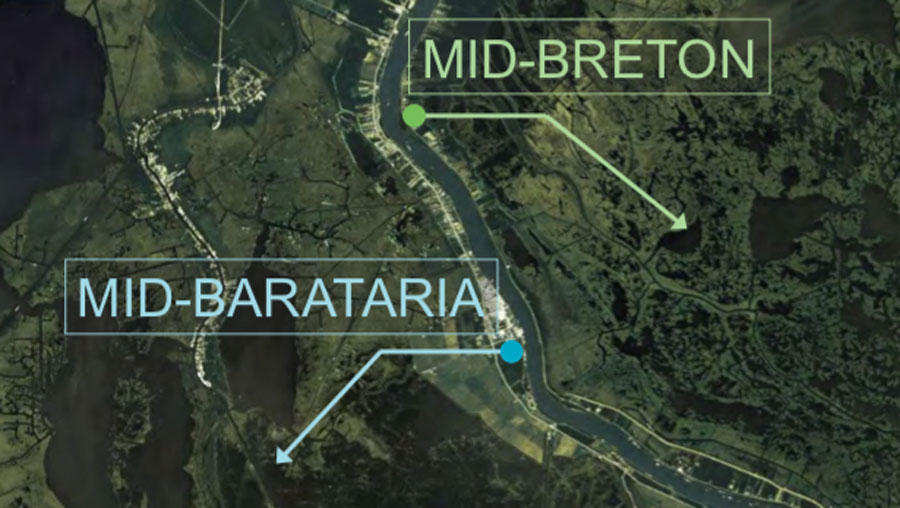
The State of Louisiana has responded to that land and habitat loss with a coastal restoration and protection master plan consisting of levees, floodgates, barrier island and marsh restoration as well as gates in the river’s levees, called “diversions” that will send sediment-laden flood waters back into the marshes.
This map shows the sites of two diversions proposed in the master plan.
The recent, unprecedented freshwater flush across the northern Gulf from the Mississippi River, plus flood-stages on the Pearl River and the Mobile River Delta, sent many commercial and recreational fishermen scrambling to find speckled trout, shrimp, crabs and oysters displaced or, in some cases, killed by the flooding. Local elected officials have asked the federal government for fishery disaster assistance to help address the business losses.
While catches of speckled trout, white shrimp and crabs rebounded in the Pontchartrain Basin after the spillway was closed in July 2019, and redfish and bass catches stayed strong throughout the flood, the spillway opening and other flooding has some in Louisiana and neighboring Mississippi questioning if the planned diversions to save and sustain coastal marshes will have similar impacts.
“The flooding we saw was unprecedented and the Corps of Engineers had no choice but to open the Bonnet Carre’ when the waters threatened New Orleans,” said Brian Lezina, the Planning and Research Division Chief for Louisiana’s Coastal Protection and Restoration Authority. “But, the way that spillway works, by moving 200,000-300,000 cubic feet per second into the open and relatively deep waters of Lake Pontchartrain and then into Mississippi Sound and the Gulf strictly for flood prevention is not how a diversion built specifically to benefit marsh and build habitat is going to function.”
HARD CHOICES
The Louisiana Coastal Master Plan calls for two sediment diversions south of New Orleans, one west of the river called the Mid-Barataria Sediment Diversion and one east, the Mid-Breton Sediment Diversion. Both are being designed with a maximum flow rate of 75,000 cubic feet per second, far less than the Bonnet Carre’. They are also designed to operate when sediment loads are at their highest in the river, generally from late winter through late spring, to maximize land-building, but at lower flow rates when suspended sediment wanes. Operation plans would allow saltier conditions to return from early summer through late fall each year, the way the river would generally behave.
Lezina and his colleagues have conducted more than 100 public meetings in the last four years with various stakeholders to try and address concerns about the projects and discuss the possible positive and potentially negative affects to fisheries. He said data suggest natural ridges and the small volume of water from the Mid-Breton Diversion compared to the volume of salty waters in the Gulf means different impacts than a Bonnet Carre’ opening.
“Capturing that suspended sediment in the river’s current is essential to sustaining and building wetlands and also preserving the crucial habitat that blue crabs, shrimp, speckled trout, redfish, waterfowl and many other estuarine animals need,” Lezina said. “The majority of popular commercial and recreational estuarine species have evolved with the seasonal inputs of sediment, freshwater, and nutrients. The habitats they rely on for survival, such as vegetated mudflats and marshes rely on that cycle as well. We can control the flow rates of the diversions to mimic the estuary in the same way the river would have done without the levees cutting the system off.”
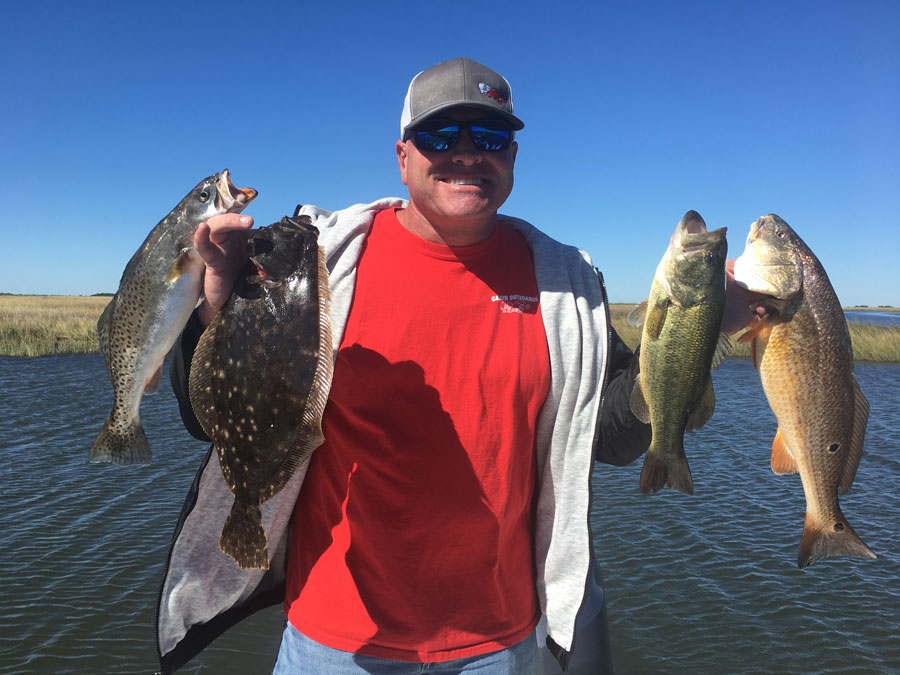
The Bonnet Carre Spillway opening has increased the diversity of the fish in the areas east of New Orleans. This bass, flounder, speckled trout and redfish were all caught in an area inundated by freshwater from the spillway just a couple months after the spillway closed
Many commercial and some recreational fishermen in the areas that will be most affected by the diversions have opposed construction outright despite project openings that are a decade or more away and the crippling coastal land loss of the last century.
Captain Charlie Thomason operates a fishing lodge and guide service east of New Orleans in the town of Hopedale. Areas he fishes will be in the outflow area of the Mid-Breton Diversion. He said he doesn’t completely oppose using the river to rebuild marshes but questions the need for such high flow rates and if his business can survive the seasonal changes to the fishery.
“You look at all the marsh we’ve lost just in the last 20-30 years and there’s no question that something has to be done to address it, but I think the diversions in the Master Plan are just too large,” Thomason said. “The velocities may hurt our marsh and it will certainly change our fisheries half the year. Our clients want to come here to catch redfish and speckled trout year-round and what we’ll be faced with is a fishery where we’ll have trout to catch in the late summer and fall but not the other six or seven months. Our clients will take their business to other places and not come back.”
Thomason said he thinks the Master Plan does a good job of prescribing marsh creation and barrier island projects built with dredges, but wants any diversions to be closer to the levees, smaller and designed to extend out Gulf-ward as sediment is deposited.
Captain Ryan Lambert runs a guide service and lodge 30 miles south of Hopedale in Buras where he focuses on redfish and speckled trout throughout the year and waterfowl hunting in the late fall and winter. He has been one of the state’s most outspoken proponents of sediment diversions despite the difficult conditions caused at times by the river. East of Buras is one of a handful of places in Louisiana where natural bayous and crevasses connected to the river are depositing sediment and building land each year.
“We have to have that sediment and that water coming out of the river to build our land and habitat,” Lambert said. “With all of the cuts and passes east of the river, we are dealing with hundreds of thousands of cubic feet of water when the river is high, but we still fish there because that’s where the habitat is good and where we can catch fish.”
He contrasts that with the west side of the river where there is no connection to the Mississippi River and the marsh has subsided and been battered and eroded by hurricanes.
“I used to spend 90 percent of my time fishing the marsh west of Buras, but now it’s nothing but open water for six miles between me and the Gulf,” Lambert said. “Without that marsh, the mudflats and the grass, our juvenile shrimp, fish and crabs can’t survive. We must have that water and sediment feeding our habitat. Without it, we have no fish. We have no future.”
This article previously appeared in the Jan/Fed 2020 issue of TIDE Magazine.
HOW YOU CAN HELP
CHEERS TO CONSERVATION
Theodore Roosevelt’s experiences hunting and fishing certainly fueled his passion for conservation, but it seems that a passion for coffee may have powered his mornings. In fact, Roosevelt’s son once said that his father’s coffee cup was “more in the nature of a bathtub.” TRCP has partnered with Afuera Coffee Co. to bring together his two loves: a strong morning brew and a dedication to conservation. With your purchase, you’ll not only enjoy waking up to the rich aroma of this bolder roast—you’ll be supporting the important work of preserving hunting and fishing opportunities for all.


The article is very nice but failed to mention some key partners who did all of the groundwork and several pilot research studies between 2002 and 2018. These partners include Johnson Engineering and Florida Gulf Coast University and they continue to work on this project by monitoring the ecological response of fishes, invertebrates and growth of Vallisneria americana outside of the exclosures.
Having fished the Indian River Lagoon for the past 30 years, I have seen the loss of sea grass habitat and reduced fishing opportunities caused by that loss. However, the problem goes deeper than changes in salinity. An overload of nutrients from development, municipal sewage and agricultural sources led to the brown tide that killed off the sea grass and the remaining game fish in the Lagoon.