fbpx

March 4, 2019

Ghost Forests Are a Haunting Reminder of Louisiana’s Lost Wetlands

How an ambitious plan for Gulf coast restoration will allow cypress forests to rebound, support wildlife, and defend communities from deadly storms

The bald cypress tree is an icon in Louisiana, like a Mardi Gras mask or the fleur de lis on the side of a New Orleans Saints helmet. Millions of acres of winding bayous, overflow swamps, lakeshores, and seasonal crevasses are lined with our majestic state tree, along with tupelo gums, swamp maples, and the occasional stately oak.

Wading birds, wood ducks, bald eagles and many others take rest and often make their nests in the cypresses. Fishermen pitch plastic worms, spinnerbaits, and tube jigs at a maze of cypress roots to catch bass, bluegills, and sac a lait—those are crappies to you east coasters.

But cypress forests do more than define our landscape and support our wildlife—they also store flood waters during the spring, help hold the loose soils of South Louisiana together, and provide natural protection to coastal communities by curbing ravaging hurricane winds and storm surge.

Unfortunately, large swaths of coastal cypress forests have been wiped out across South Louisiana. Initially, the trees were overharvested to build houses, railroads, and anything else that needed wood. Later, levees built on the Mississippi River to facilitate navigation and oil and gas extraction pushed salt water from the Gulf inland as much as 50 miles. And navigation canals were carved into the swamps, causing even more destruction.

Healthy bald cypress wetlands (left) versus a ghost forest (right).

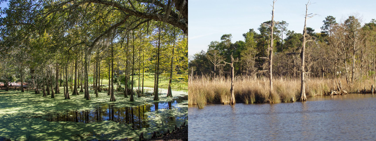
Dead expanses of trees, often called “ghost forests” by locals, are scattered throughout the coast in impounded swamps and among the saltwater-tolerant cord grasses that took hold where no other plants could live. The Cajun old timers speak of when they used to duck and deer hunt and catch bass and crawfish in these same cypress breaks decades ago.

Now, preserving the existing coastal forests and replacing some that were lost in the last century is a top priority in Louisiana. The state’s Coastal Protection and Restoration Authority has spent $15.8 million since 2011 to buy coastal forest lands from willing sellers, preserve the habitat, and ensure the trees aren’t harvested. About $2 million of this funding, plus another $6.5 million in settlements from the 2010 Deepwater Horizon oil disaster, were used to help expand the Maurepas Swamp Wildlife Management Area—a more than 100,000-acre public tract of cypress-tupelo swamp between Baton Rouge and New Orleans.

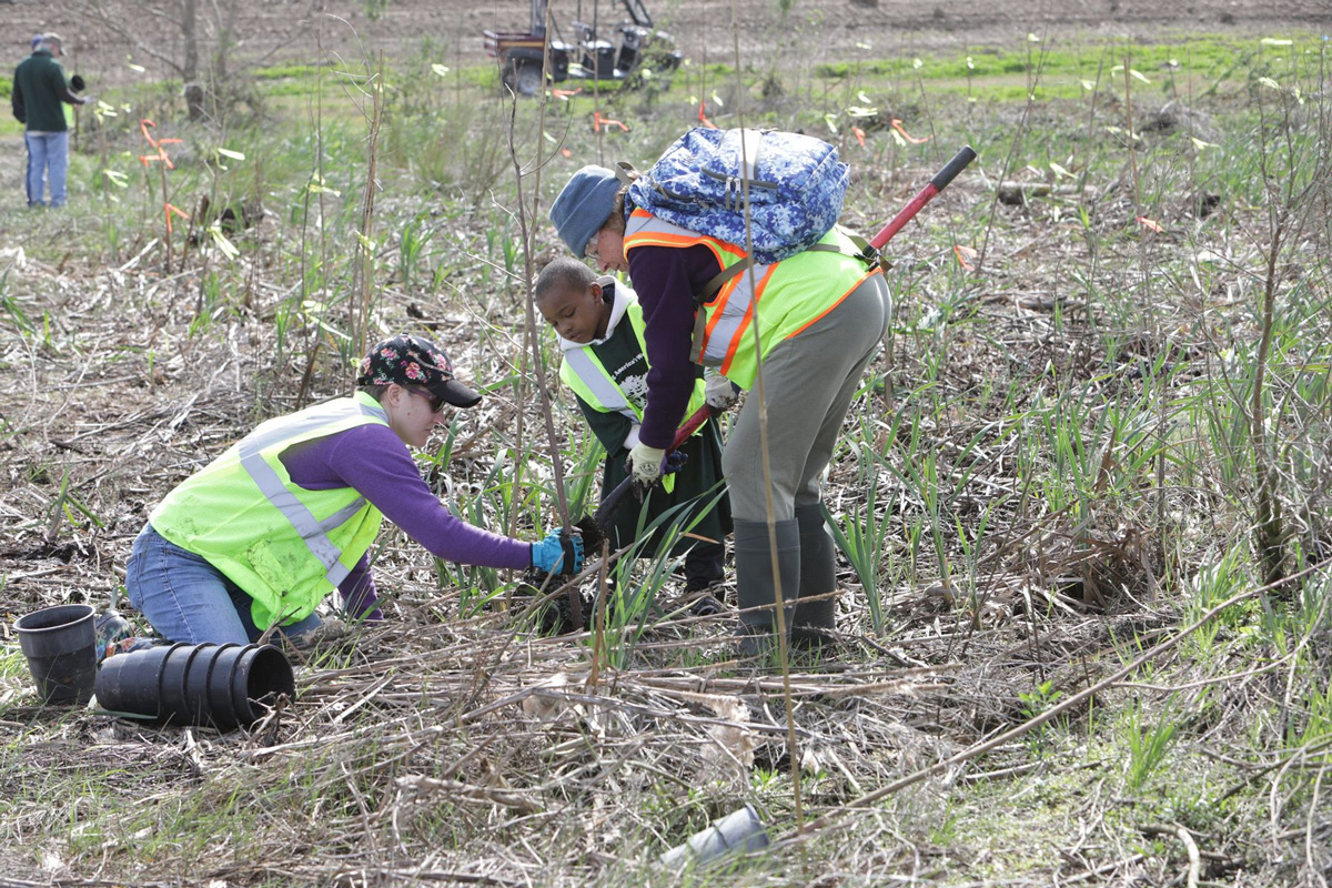
Non-profit organizations, like the Lake Pontchartrain Basin Foundation, America’s Wetland Foundation, and Coalition to Restore Coastal Louisiana, have invested hundreds of thousands of dollars and utilized countless volunteer man-hours to plant cypress trees in areas where over-harvest and saltwater intrusion has made it impossible for the trees to regrow on their own.

These noble efforts would be fruitless, however, without additional work to limit the saltwater intrusion that initially caused the trees’ demise. Rebuilding coastal barrier islands, replenishing marshes and natural ridges with dredged sediment, and building diversions to allow the Mississippi River to again spill into its deltaic swamps will keep the Gulf of Mexico at bay and allow coastal forests to grow back into vital fish and wildlife habitat and hurricane protection.

Volunteers help replant a historic cypress forest in Pointe-aux-Chenes Wildlife Management Area. Photo by America’s Wetland Foundation.

Louisiana has an aggressive coastal restoration and hurricane protection master plan that aims to build a host of projects needed to reconnect the Mississippi River to its historic delta, restore coastal marshes, and keep salt water in the Gulf. This is just another example of how the state’s nearly $8-billion share of the Deepwater Horizon settlement is rebuilding a better coastline in the next two decades.

The TRCP and its partners have worked closely with Louisiana and federal lawmakers and agencies to expedite permitting and construction on these projects while educating sportsmen and women about the benefits to fish, wildlife, and the outdoor recreation economy.  

The money is available. The projects have been designed to help reverse the factors that have led to the loss of nearly 2,000 square miles of coastal swamps and wetlands in the last 100 years. But it will continue to take strong political will to make sure these projects, especially those designed to reconnect the Mississippi River, get built quickly.

That political will must come, in large part, from the hunters and anglers who live in or visit Sportsman’s Paradise. To see what coastal restoration projects can do for fishing, watch this video.


Top photo by Kent Kanouse via flickr

3 Responses to “Ghost Forests Are a Haunting Reminder of Louisiana’s Lost Wetlands”

  1. I think you need to correct one thing in your article. Levees were first built along the Mississippi in New Orleans to prevent flooding. Different landowners along the river started building them also to protect homes and cropland. It became a necessity because areas without levees or with lower ones would be the first to flood. Eventually, the Corps of Engineers got involved and started building them to a consistent size and quality. That might be why the idea that the levees were to facilitate navigation came from, because flood control was not an authorized mission of the Corps of Engineers. Navigation was part of their mission.

Do you have any thoughts on this post?

XHTML: You can use these tags: <a href="" title=""> <abbr title=""> <acronym title=""> <b> <blockquote cite=""> <cite> <code> <del datetime=""> <em> <i> <q cite=""> <s> <strike> <strong>

Comments must be under 1000 characters.

March 1, 2019

Sportsmen Warn Against Weakening Conservation in Roadless Areas

Sportsmen and women band together to conserve Utah’s backcountry lands

Today, the state of Utah petitioned the U.S. Department of Agriculture and U.S. Forest Service to develop a state-based rule managing 4 million acres of roadless areas on national forest lands within the state.

In Utah, backcountry areas that are not fragmented by roads are currently conserved under the 2001 Roadless Area Conservation Rule, which was created through years of stakeholder engagement.

“For nearly two decades, the roadless rule has successfully conserved some of the finest hunting and fishing destinations in Utah and across the nation,” says Whit Fosburgh, president and CEO of the Theodore Roosevelt Conservation Partnership. “It is unnecessary and counterproductive to abandon this tried-and-true policy and go back to the drawing board. Doing so will only drain the time and resources of public agencies already stretched thin.”

Prime habitats and hunting and fishing country from the Wasatch and Uinta Mountains to the La Sals could be affected by this rulemaking process.


Top photo by Brandan Rasmussen via flickr.

February 25, 2019

EPA’s New Rule Will Muddy the Waters in Georgia

A hunter, angler, and public land advocate details how a revised Clean Water Act rule would affect his backyard, and yours too

Take action now and urge the EPA not to overlook critical fish and waterfowl habitat. 

On December 11, the Environmental Protection Agency proposed a policy that would eliminate Clean Water Act protections for streams that only flow after rainfall. The EPA claims that this change will simplify the construction of homes or buildings, as projects that could affect a protected waterway require a federal permit. But there can be little doubt that this new rule will only muddy the waters in my home state of Georgia.

That’s because we simply don’t know which of our streams flow only after rainfall and which ones can be counted on to flow predictably year after year. By the federal government’s own admission, they don’t have a good understanding of this either. Federal agencies know which streams meet those criteria in much of the western portion of the United States, but they haven’t conducted the same studies in much of the rest of the country.

The EPA’s new rule also complicates the applications of the Clean Water Act for wetlands, marshes, swamps, and flood plains. Those without a surface connection to a larger waterway would no longer be protected and could therefore be vulnerable to pollution and destruction. It has been estimated that more than half our wetlands nationwide would be affected.

But again, this might not be the full picture. These estimates are based on data that does not include any wetlands smaller than one acre. And wetlands in forested areas, which are plentiful in Georgia, can be difficult to identify.

In short, we all should rightly wonder what the true impact of this policy change will be in our backyards.

The Clean Water Act holds polluters accountable for damage to waterways covered by the act, but how can it do so when officials no longer know which streams those are? And why would companies be eager to build when it becomes dramatically more difficult to determine whether they are impacting a protected area?

What’s clear is this: This change would cause untold confusion in our state. If the EPA only wanted to simplify things while maintaining the Clean Water Act’s effectiveness, the new rule has completely missed the mark. The only way forward is to abandon this shortsighted proposal and conduct the research needed to create a science-based policy. Georgians deserve nothing less.

Read the rule as published in the federal register here

The TRCP is asking hunters and anglers to take action here

A resident of Atlanta, Patrick is the Director of Finance at Keep It Public, a 100% volunteer run 501(c)3 non-profit organization that works to build coalitions between different public land user groups from hunters to birdwatchers. In addition to his work with Keep It Public, Patrick works in marketing and advertising. From backcountry skiing to hunting in the Rockies, Patrick is an enthusiastic public land user.


Photo courtesy: Wayne Hsieh

February 22, 2019

A Meeting of the Minds on Migrating Wildlife and Highway Collisions

A TRCP-led workshop brings biologists, planners, and engineers together to resolve a massive obstacle to big game migration—our roads and highways

With a spectacular sunset hanging over the Nebraska prairie, I loaded my chocolate labs into the truck at the end of a great afternoon of sharptail grouse hunting. It had been the perfect rest stop to break up a long drive, while also yielding some exercise, a limit of birds, and another memory in the field. But it was time to get moving.

Pulling off a deeply rutted dirt road onto pavement, I accelerated to the speed limit—or thereabouts— set my cruise control, and settled in.

And then it happened. Before I could pump the brakes, flash the lights, or honk the horn, I was on top of a small herd of mule deer with only enough time to grab the steering wheel tight and brace for the inevitable impact. Once the vehicle slowed to a stop, I spun the truck around and returned to where my vehicle had struck one of the does.

I’ve walked up on many big game animals taken while hunting, usually with a strong mix of emotions, and always grateful. But as I approached the dead deer on the side of the highway, I only felt regret for what seemed like a useless loss of life.

An All Too Frequent and Costly Scenario

I suspect nearly every sportsman or woman has a story—or several—about collisions and near misses with wildlife on roads and highways. According to the Highway Loss Data Institute, drivers filed more than 1.8 million animal-strike claims, mostly involving deer, at an average cost of about $3,000 each between 2014 and 2017. That’s a more than $5.4-billion cost to insurance companies alone in just four years.

These accidents also cost state transportation and wildlife agencies dearly in time, resources, and other expenses. Rural states like South Dakota, Montana, and Wyoming, which have high rates of vehicle-wildlife collisions, spend upwards of tens of millions of dollars annually responding to wildlife-vehicle collisions.

But this issue goes beyond safety hazards, loss of human and animal life, property damage, and other economic costs.

Can Deer Even Cross the Road?

Roads and highways are pervasive features across landscapes where they never used to be. By their very nature, they break up habitat into fragments and have the potential to severely disrupt animal migrations. The numerous interstate highways that cross our nation north to south and east to west present major obstacles for animals trying to move from one area to another to reach seasonal habitat and winter range.

Maps overlaid with GPS-collar data show quite clearly how abruptly migrations halt in cases where animals reach an interstate highway. Data from several studies compiled by the Wyoming Migration Initiative indicates that I-80 in southern Wyoming serves as a significant barrier to movement for pronghorn antelope, mule deer, and elk. Likewise in Arizona, biologists have identified a 31-mile segment of I-17 as a hotspot for collisions and a movement barrier for migrating elk.

Fortunately, there are solutions in the form of structural crossings that allow animals to move either over or under the highway, and ample scientific evidence illustrates their effectiveness. More than 20 years ago, the Canadian government installed six overpasses and 38 underpasses along the Trans-Canada Highway, long recognized as a barrier for big game and other wildlife. Now, it’s considered an international conservation success story—these efforts reduced vehicle-wildlife collisions by 80 percent.

Many states across the U.S. have enjoyed similar results from installing over- and underpasses along major highways. Wyoming’s Trapper’s Point on Highway 191 and Highway 9 in Colorado are good examples of how effective this approach can be. Still, there are many places where wildlife-vehicle collisions and barriers to movement remain a problem for human safety and the conservation of our big game herds.

Migration routes of GPS-collared elk, mule deer and pronghorn in southern Wyoming demonstrating the barrier effect on movement of these species of big game (map: Wild Migrations: Atlas of Wyoming’s Ungulates Oregon State University Press
© 2018 University of Wyoming and University of Oregon).
Bridging the Gap

When former Secretary of the Interior Ryan Zinke signed an Order to improve habitat quality in big game winter range and migration corridors—a policy lauded by sportsmen and women—the Department asked the 11 Western states covered by the policy to submit their top three to five priority project sites for mule deer, elk, or pronghorns to be worked into collaborative action plans. Significantly, highway crossings ranked among the top priorities for every state. Some even called out multiple roadways—all five of Idaho’s priority projects involved highways and issues with animal movement and collisions.

That’s why DOI asked the Theodore Roosevelt Conservation Partnership to organize a gathering of experts and decision-makers to discuss how we can get more wildlife crossings where they are most needed.

More than 80 participants from 11 state wildlife agencies, 12 state departments of transportation, three federal agencies, and several NGOs and foundations gathered in Salt Lake City in late January. We discussed the differences in how wildlife agencies and DOTs operate, lessons learned from past efforts, assessed what policies currently exist, and identified partnership, funding and policy needs to address the issue.

Mule deer crossing on an overpass on Highway 9 in Colorado (photo courtesy of J. Kintsch) and moving through an underpass in Wyoming (photo courtesy of Wyoming Game and Fish Department).
Collaboration Will Be Key

While Wyoming, Colorado, and Montana had held similar workshops at the state level, never before had professionals from multiple states gathered together to discuss highways and big game migration and collisions to learn from one another’s successes and failures. And this collaborative aspect was key for the success of the event. We wanted to foster connections across state agencies and among stakeholders, identify best practices and key points of leverage for action, and advance the states’ priorities under the Secretarial Order on migration.

It became clear that engineers with state DOTs—the talented people who build and maintain roads, bridges, and other structures to allow the movement of vehicles safely and efficiently from point A to B—and biologists need to work better together. Monte Aldridge from the Utah DOT summed up this lesson very simply, advising wildlife managers to “get to know an engineer.”

Another takeaway was that wildlife and personnel from a state DOT and wildlife agency personnel need to communicate early and often, with an eye towards solutions that allow all parties to achieve their goals. In the past, by the time wildlife professionals engaged in the planning process and identified the need for an under- or overpass, it might have been too late.

And, of course, all participants recognized that there is never enough money to go around. Ideas were exchanged about how NGOs, foundations, private landowners, and other entities can partner with federal agencies to help state wildlife agencies and DOTs successfully fund and maintain wildlife highway projects.

Participants at the big game and highways workshop (EBA photo).
The Worst Thing We Can Do Is Nothing

Utah DOT Executive Director Carlos Braceras gave voice to the spirit of the workshop by quoting Theodore Roosevelt and telling the crowd that “the best thing we can do is the right thing, the second-best thing we can do is the wrong thing, and the worst thing we can do is nothing.” He encouraged the group to share not only their successes but also their challenges, pitfalls, and mistakes so that others can learn from them.

The work ahead is really where the proverbial rubber will hit the road, not only for the state-identified priority projects, but also for the many areas across the country where wildlife and transportation conflicts need attention. This workshop was one step toward helping to ensure our wildlife conservation and transportation needs can be integrated, and the lessons learned should help with the larger efforts down the road.

Among other things, this gathering illustrated the role that the sporting community must continue to play as a partner with our state and federal agencies and other stakeholders to address wildlife-transportation conflicts. The solutions, while expensive and not easily planned or installed on a whim, are well-studied and proven. But we need to encourage the support and political will of agency leads and decision-makers to help keep the momentum rolling.


Top photo: Gregory Nickerson/Wyoming Migration Initiative

February 21, 2019

Public Land is Too Important for Sportsmen to Sit Out on Planning

America’s public lands agencies go through a planning process that may sound tedious, but it’s your chance to have a say in how habitat and hunting and fishing areas will be managed for 20 years or more—it’s your land, so be part of the plan

America’s public lands embody our nation’s ideals—they’re owned by every one of us and, no doubt, they offer opportunity to all, regardless of one’s background or standing. But public lands reflect our culture in yet another way: The American people themselves determine how these lands should be managed and in what condition they will be handed down to future generations.

This happens through the land-use planning process, the goal of which is to produce documents that outline how the Forest Service and BLM will balance the many demands on public lands in a particular area. Wildlife habitat, outdoor recreation, grazing, timber harvest, and energy extraction each have their rightful place on our public lands, and this process ultimately determines where and when these various uses occur.

When organizations like the TRCP ask sportsmen and women to engage in the public process of planning for future public land use, it may sound like too much of a burden on your time—we ask you to read this, learn more, click here, show up, and speak out. But the land-use planning process is the American public’s best opportunity to see that our land is managed according to our values.

Here’s everything you need to know about land-use planning and how you can get involved.

The Basics

This process begins with an assessment of the resources in, say, your local national forest or your local BLM field office, and a consideration of the various ways in which those resources could be utilized. Afterward, the public weighs in on these different options and voices its opinions on how its lands should best be managed.

The resulting product, usually some combination of proposals from several plans, sets the agency’s goals for the management of a given area over the ensuing decades.

Land-use plans guide every on-the-ground action of our land management agencies. They allocate resources and determine appropriate multiple uses for our land; they outline strategies to manage and conserve our resources; and they set up a process for measuring the success of these strategies over time. Decisions such as where to build and maintain roads and trails, how to balance wildlife habitat with development, and where to prioritize active habitat management take their shape from these critical documents.

Credit: BLM/Photo by Mike Howard
Why Plan?

The agencies that manage our public lands face competing claims and requests on a daily basis from various stakeholder groups. Land-use planning emerged during the 1970s, when our public lands faced escalating demands on natural resources and Congress directed the agencies to more conscientiously manage public lands for many uses.

Planning ensures that decisions across a landscape don’t collectively undermine the values that the American people believe should guide its management. It is a forward-looking process and ultimately will determine the outdoor legacy that today’s sportsmen and women will pass on to the next generation.

Your Role in Land-Use Planning

Each federal agency has its own specific process for planning, but they are all required to involve the public in the process by rules established in the National Environmental Policy Act.

This is why formal public comment periods are typically incorporated into two phases of the planning process—initially during the “scoping” period and then again after the completion of a draft land-use plan. National forest planning includes additional opportunities for the public to be involved early on, while the BLM’s “pre-planning” for Resource Management Plan (RMP) revisions is for the most part internally focused on budgets, staffing, etc.

In the scoping phase, the agency informs the public of its intention to revise or rewrite an existing land use plan. At this point, a public comment period offers hunters and anglers a critical opportunity to raise issues of concern and provide recommendations for public land management within the planning area.

After taking into account these comments, the agency will develop a draft land-use plan that outlines several potential options for how to manage the landscape, known as “proposed alternatives” in agency lingo. Generally speaking, they will range from minimal restrictions on extractive industries to maximum consideration for conservation priorities. The agency will also recommend one of these specific options—usually somewhere in-between these two extremes—as its preferred alternative.

Here, we know which way the agency is leaning, but another public comment period allows hunters and anglers to weigh in and influence the outcome of the process. The agency can include in the final plan any of the measures proposed in the full range of alternatives, so public comments can recommend the best ideas from any of the various options.

Even though one alternative is preferred, it isn’t over until it’s over.

The onus is on the BLM and Forest Service to be transparent about this process. The agencies must formally announce the duration of each comment period, as well as where, when, and how comments can be submitted. In addition to written submissions, the scoping and draft-plan phases allow the public to voice comments in person at meetings held by the agency in local communities. Both methods of input receive the same consideration, but sharing your story face-to-face can certainly make your concerns more compelling to agency personnel.

By law, the agency must consider all of these comments as the final land-use plan develops. That document must be reviewed by the governor of that state and can be formally protested by the public before it is formally adopted through a “record of decision.”

Credit: Zachary Collier
What’s At Stake?

Although hunters and anglers have stepped up with overwhelming passion when threatened by proposals for public land transfer and disposal (remember the amazing response to Rep. Jason Chaffetz’s H.R. 621?), it’s difficult to bring that same energy to the proactive planning process.

Nonetheless, RMPs and Forest Plans couldn’t be more critical to the future of wildlife, access, and our public land traditions. These documents in large part determine whether development will be balanced with the interests of wildlife and sportsmen. They can ensure that our highest-value hunting and fishing grounds remain accessible and intact and that existing outdoor recreation opportunities will be defended—and improved—for future generations.

But that all depends on our community speaking up. You can be absolutely certain that other stakeholders will advocate for their interests during the planning process, so sportsmen and women can’t afford to sit on the sidelines.


Top photo: Eliot Phillips

HOW YOU CAN HELP

CHEERS TO CONSERVATION

Theodore Roosevelt’s experiences hunting and fishing certainly fueled his passion for conservation, but it seems that a passion for coffee may have powered his mornings. In fact, Roosevelt’s son once said that his father’s coffee cup was “more in the nature of a bathtub.” TRCP has partnered with Afuera Coffee Co. to bring together his two loves: a strong morning brew and a dedication to conservation. With your purchase, you’ll not only enjoy waking up to the rich aroma of this bolder roast—you’ll be supporting the important work of preserving hunting and fishing opportunities for all.

Learn More
Subscribe

You have Successfully Subscribed!

You have Successfully Subscribed!

You have Successfully Subscribed!

You have Successfully Subscribed!

You have Successfully Subscribed!