fbpx

May 31, 2018

This State Has One-Third of the Country’s Abandoned Mines (and It’s Bad News for Fish)

Abandoned mines have harmful effects on water quality and fish habitat across the country, but lawmakers can make it easier for volunteers to shoulder some of the cleanup effort without taking on big risks

Coal mining may be a major part of Pennsylvania’s cultural history, but groups like Trout Unlimited are concerned that abandoned mines could threaten the future of some of the state’s most popular trout streams.

Here are the numbers: There are roughly 500,000 abandoned mines across the country—46,000 of these are on public lands—where heavy metals and acidic runoff cause water quality issues on approximately 110,000 stream miles. With 20 percent of these waters serving as habitat for native trout or salmon, this should be of national concern to anglers.

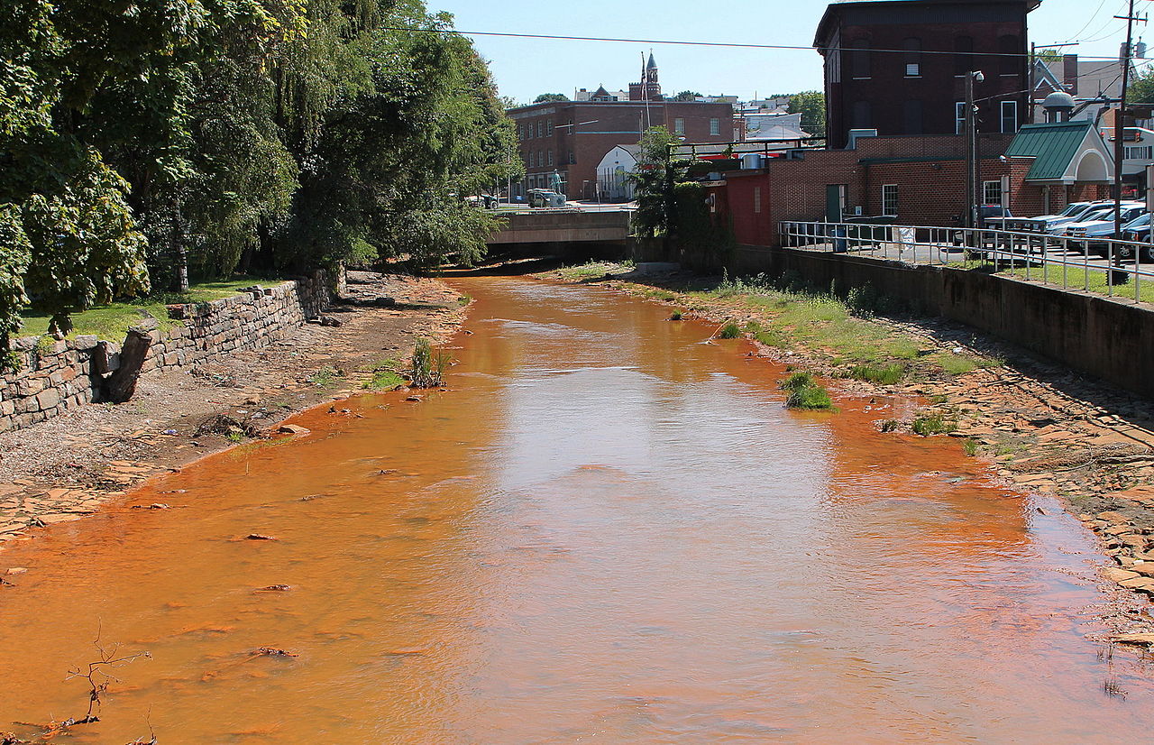
But the backlog of abandoned mines really hits home in the Keystone State, where one-third of all derelict mining operations in the U.S. are located. As of 2006, this left the state with approximately 4,000 miles of streams that were essentially devoid of all aquatic life, according to the Pennsylvania Fish and Boat Commission.

The good news is that elected officials have an opportunity to let well-intentioned groups and volunteers get in on the daunting task of cleaning up the mess, with legislation that would remove a major hurdle.

Shamokin Creek looking upstream in Shamokin, Pennsylvania
A New Endgame

These days, before a coal mine commences operations, a plan is created for its eventual shutdown—even if that may be decades down the road. Mining companies have to figure out how they will dispose of leftover waste and complete a full cleanup, but this wasn’t always the case.

While some states started regulating the coal industry in the 1930s and 1940s, the federal government didn’t begin regulating active coal mining until 1977. At that time, Congress passed the Surface Mining Control and Reclamation Act to address concerns about the environmental effects of roughly two centuries of mining in the United States.

It used to be that businesses would simply pack up and leave when mines were no longer productive, forcing the surrounding community to deal with the negative repercussions on water resources and the local economy. In many cases, these abandoned mines were “orphaned,” meaning that the government cannot find the original mine owner, which puts taxpayers on the hook for the cleanup. The surface mining legislation of the 70s required that mining companies abide by a set of environmental standards and create plans for the reclamation of land after mining was complete.

Photo by Steve Droter/Chesapeake Bay Program via flickr
The Cost for Fish and Water Quality

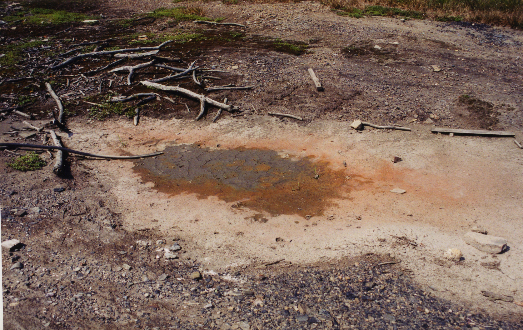
People who live near abandoned mine sites can be exposed to serious health hazards from the toxic runoff, so it’s easy to see how bad this can be for fish. Sediment runoff can carry contaminated silt and debris downstream, clogging waterways and altering river flows that keep water at a steady temperature for coldwater fish. Highly acidic waters that come out of abandoned coal mines can decimate fish populations and make some streams completely uninhabitable for any aquatic life, including food sources important to fish we love to catch.

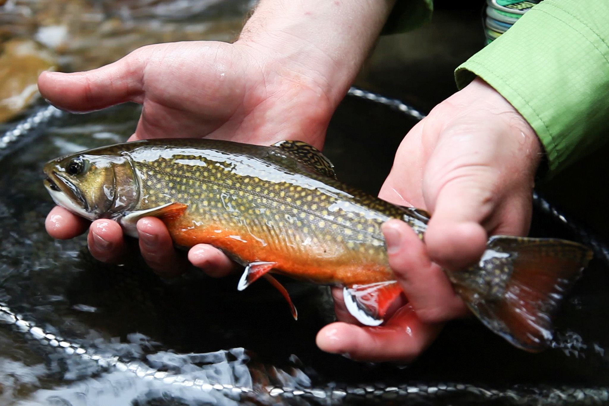
Some of the Pennsylvania’s severely impaired streams are dangerously close to highly productive fisheries. For example, the headwaters of Kettle Creek are Class A wild trout waters popular with fly fishermen, but fifteen miles of the main stem were virtually lifeless by the 1950s because of past mining activity.

That’s where Trout Unlimited stepped in to help. They partnered with Kettle Creek Watershed Association in 1998 to install passive treatment systems that help normalize highly acidic water and, utilizing traditional remediation techniques, they’ve been able to clean up almost the entire creek, which has reopened fishing access in places like Twomile Run.

But even well-intentioned groups like TU have to overcome two major hurdles to help with cleanup efforts that are critical to ensuring that the next generation has quality places to hunt and fish.

Sulfur in the ground.
Here’s the Rub

The Surface Mining Control and Reclamation Act also created a means of paying for the cleanup of abandoned mines by assessing a small fee on every ton of coal produced. Since the creation of this trust fund, more than $5 billion has been distributed to states in the form of grants to help clean up abandoned mining lands.

But funding for this program expires in 2021. It might not seem urgent, but the last reauthorization took nearly a decade, and opponents of the trust fund are already advocating for the immediate end of the program and fees on the production of coal.

Even if we secure this important funding, there’s an urgent need for “Good Samaritan” legislation that will allow non-federal entities, like TU, to help clean up abandoned mine sites.

Under current legislation, if a nonprofit steps in to help clean up an abandoned mine site, they are legally liable for any issues with the site in perpetuity, even if they had no prior connection to the project. This limits the opportunities for volunteer groups or organizations to shoulder some of the burden of cleaning up and helping to restore fish and wildlife habitat for the next generation, because they cannot take on the incredible risks.

Pennsylvania has provided reasonable liability protection for groups that want to help clean up abandoned mines, and many organizations have stepped up. We’re supportive of TU’s efforts to educate sportsmen and women about Good Samaritan legislation and the ongoing risks abandoned mines pose to fish, wildlife, and clean water in Pennsylvania and across the country.

Watch their video to learn more.


First and last photo by Peter and Laila via flickr

6 Responses to “This State Has One-Third of the Country’s Abandoned Mines (and It’s Bad News for Fish)”

  1. Damon Graham

    I would appreciate the opportunity to reach out to my elected officials to let them know that this issue is important to me. The TRCP does a fantastic job creating documents that outline our needs and I have enjoyed putting my name on them as they are passed to my representatives.

  2. Joe Tieger

    SMCRA included loopholes that let the companies “self bond”, that is let the assets of the company act as the financial assurance for the reclamation of the site. However, many companies escaped their liability through bankruptcy. SMCRA funds weer not, are not, and never will be adequate to pay for the necessary reclamation and, equally important the ongoing water treatment needed for the drainage and leachate from the pits and waste heaps. The coal mining states and OSM, politically controlled by the mining companies have never required adequate financial assurances – AAA Bonds, third party insurance, funded irrevocable trusts, letters of credit that would not disappear in bankruptcy court. Good Samaritan legislation allowing independent parties to conduct response actions can be helpful if there are requirements for plan review and some oversight – a bad effort can make things worse. It is also important to note that coal is made up of many elements including a spectrum of toxic substances . Depending on the deposit these can range from aluminum (toxic to fish) through uranium. The state and federal governments have let the mining companies escape their liability for environmental damage through weak laws and enforcement.

  3. I was born and raised in Schuyllkill County, PA. I visited the west with some family at 10 years of age. What an eye opener. I went to Minersville High School. We were the Battlin Miners in sports. A Miners sillouette was our logo. The entire County was trashed. Water was orange, white, yellow, obsidian black during runoff. The water was so acidic, fish could not live. I still visit family there. No one seems to notice the desolation. I went in to the military in the late 60’s and have spent a few years there afterwards. I earned a natural resource degree in the west, and hope to die here. I live to hunt, fish, hike, backpack, etc. The mine companys have controlled the government there since the 1800’s. I’m pretty convinced a nuclear war would only improve the place. You could not pay me enough money to live in that hellhole. God must cry every time he looks down.

  4. Don Kromer

    It’s time to get on the backs of the politicians and get this reinstated, Everyone call their respected representative , send a ton of e-mails, and get pro-active.

Do you have any thoughts on this post?

XHTML: You can use these tags: <a href="" title=""> <abbr title=""> <acronym title=""> <b> <blockquote cite=""> <cite> <code> <del datetime=""> <em> <i> <q cite=""> <s> <strike> <strong>

Comments must be under 1000 characters.

May 30, 2018

Sportsmen Lead the Way for Wildlife on Nevada Public Lands

Revision of BLM land-use plan offers an opportunity for policymakers to support sportsmen’s efforts and follow through on the administration’s commitment to access and habitat

On a Saturday morning last month, more than fifty volunteers and several Nevada Department of Wildlife employees assembled at a desert camp in Mineral County for a safety meeting. Several Nevada Bighorns Unlimited board members and NDOW staff went over the plan for the day and cautioned everyone to stay hydrated and work safely.

The job at hand was to repair a wildlife water source called the Lower Paymaster Guzzler in the Gillis Mountain Range east of Hawthorne, Nevada, and to install a second guzzler adjacent to the original. Constructed more than a decade ago to retain water for the local desert bighorn population, Lower Paymaster could no longer support the number of sheep that had come to depend on it, and the structure had been damaged by excessive runoff in recent years. Even though this part of Nevada receives less than six inches of precipitation annually, it often comes as torrential thunder showers.

The Gillis Mountains are one of many important ranges in the 5.3 million acres of public land overseen by the Bureau of Land Management’s Carson City Field Office, where new land-use plans are being finalized right now. Decisions about public land access, habitat management, and development will be made through this process, and the resulting Resource Management Plan will have an impact on Nevada sportsmen and bighorn sheep, deer, and pronghorn populations for the next twenty years or more.

Fortunately, Secretary Ryan Zinke has ordered Interior agencies to expand hunting opportunities and sportsmen’s access on federal lands and improve habitat for big-game populations. If these orders are taken seriously by the Carson City BLM field office, hunters and anglers should be confident that we will be heard in the land-use planning process.

And we’ve sent a clear message: Since 2012, numerous conservation groups have called for the BLM to safeguard important hunting destinations in the Carson City BLM Field Office, including the Excelsior Range, Gillis Mountains, and Gabbs Valley Range. For these areas, Silver State sportsmen have requested that officials maintain public access, prioritize habitat restoration, secure traditional uses, and conserve the best wildlife habitats from future development.

Sportsmen’s groups have also backed conserving key habitat as Backcountry Conservation Areas to achieve these goals and Zinke’s mission. This balanced management tool was included in the draft version of the resource management plan for Carson City, but it is not yet clear if the Backcountry Conservation Area approach will be adopted in the final plan.

We feel the Carson City BLM field office has not publicly demonstrated a strong desire to prioritize sportsmen’s interests in the final land-use plan. If Zinke’s order will not persuade the local BLM to make changes to the plan, we need your help to persuade these local land managers to do right by hunters and anglers in the final RMP.

The volunteers who worked alongside me to build a critical new water source for bighorns and other Nevada wildlife have left their mark, quite literally, on this landscape and the health of these fabled herds. But a chorus of emails from concerned sportsmen is no less tangible when it comes to crafting strong policy measures for the next two decades of responsible public land management.

So please consider taking the time to speak up for Nevada’s public lands. We’ve made it easy to make your voice heard.

Top photo courtesy: BLM Nevada

May 29, 2018

Casting from a Beach that Disappeared Years Ago

Three fishing buddies land fish after fish on a stretch of shoreline that is significant to Louisiana sportsmen and conservationists—it was rebuilt with fines from the 2010 Deepwater Horizon oil spill after years of incremental habitat loss

I have been spoiled by the fishing in Louisiana for more than 40 years. Many days, my wrists have ached and my fingers have been scarred from landing countless speckled trout and redfish. There are times when, no matter how many fish I’ve caught, I can’t stand to walk out of the surf or point the boat back to the marina, because I know the next cast will mean another thump or topwater explosion.

But there are great days on the water and near-perfect ones, when the wind gods are merciful, the tide is just right, the company and camaraderie is unmatched, and the fish strike ferociously at just about anything cast their way.

I recently had one of these days in a place with particular significance to conservationists who have been following the Gulf Coast’s recovery from one of the worst ecological disasters in American history.

The Disappearing Shoreline

Perfection greeted me and two of my best fishing buddies, outdoor writer Todd Masson and Grand-Isle-area fishing guide Capt. Frank Dreher, on an early May trip to the Fourchon Beach, one of Louisiana’s most popular and renowned spring and summer fishing destinations. Two- to four-pound trout demolished a litany of lures—from topwater plugs and soft plastics to jerkbaits and minnow and shrimp lures—all morning long.

The backdrop for all this incredible fishing action just happened to be the largest coastal restoration project and the largest single investment in the recovery of the Gulf Coast after the 2010 Deepwater Horizon oil spill, something that meant a lot to three lifelong Louisianans who have seen a lot of beaches, barrier islands, and marshes vanish over the last four decades.

The Fourchon Beach is the westernmost section of a stretch of shoreline known as the Caminada Headland, which, including Elmer’s Island, stretches 14 miles between Caminada Pass and the mouth of Bayou Lafourche, once a main artery from the Mississippi River to the Gulf of Mexico about 1,000 years ago. The headland was formed by sediment deposits delivered via the Mississippi and replenished by water-borne river silt until the bayou was dammed at the river around 1900.

For the last century, hurricanes, strong winter storms, subsidence, and tidal currents have eaten away at the headland, causing the beach to retreat about 35 feet per year and threatening the more fragile marshes to its north—not to mention the energy infrastructure of Port Fourchon and camps and homes on Grand Isle, Louisiana’s only inhabited barrier island.

This land loss has also threatened the tremendous fishery along the beach, which is popular with boaters as well as wade fishermen. As most seasoned surf fishermen know, the best action of the morning is often right off the sand, giving waders an opportunity to target fish that boat-bound anglers can’t reach. I grew up fishing the Elmer’s beach with my dad, catching stringers of beautiful speckled trout and redfish and dozens of fat blue crabs in the summer.

From Off-Limits to Off the Hook

In 2010, oil from the Deepwater Horizon spill coated this beach. Many of the iconic pictures circulated in the media coverage of the spill, showing sheets of sticky, rust-colored tar mats and brown pelicans coated with oil, were taken at Elmer’s Island and the Fourchon Beach. In August of that year, not long after the Deepwater Horizon well was finally capped, I fished along Elmer’s by boat, catching trout and Spanish mackerel on topwater lures and gold spoons, just like I always have. Wading wasn’t allowed for more than two years after the spill.

Louisiana’s Coastal Protection and Restoration Authority were back with more heavy equipment and personnel in August 2013, this time to restore the beaches and dunes, rather than drag and sift them for oil. Using fines paid by the oil company and directed by the National Fish and Wildlife Foundation’s Gulf Environmental Benefit Fund, more than $200 million was invested to bring in sand from an ancient, sunken headland of the Mississippi River about 35 miles west of the Fourchon.

The entire beach was extended back into the Gulf by about 500 feet, fencing was installed to capture sand and rebuild the dunes, and sea oats were planted to hold the beach together. We at the Theodore Roosevelt Conservation Partnership joined a host of other conservation and sportsmen’s groups in championing the restoration effort because of the enormous benefit to wildlife and fish and boost to fishing access.

It is a quintessential example of the kind of project that deserves to move forward using oil spill penalties, especially considering that this funding has the potential to leave the Gulf of Mexico a better place than it was before that awful event.

So, it was a proud day to be able to cast just short of the sand on that newly restored beach and set the hook into fat, feisty speckled trout. We watched specks jump clear out of the water, while brown-and-white shrimp skipped across the surface and gulls and pelicans dove all around the boat—it’s a memory that will stay with me for a long time. And, thanks to a wise investment by the state of Louisiana with support from a broad coalition of sportsmen and environmental groups, memories will be made along that beach for decades to come.

May 23, 2018

Congress Advances Legislation to Make Infrastructure Work for Fish and Wildlife

In the past two days, committees in both chambers have passed bills to expedite Everglades restoration and advance natural solutions to America’s infrastructure challenges

Congress took major steps this week to advance legislation that includes some benefits for water quality and fish and wildlife habitat across the country.

This afternoon, the House Transportation and Infrastructure Committee passed its “Water Resources Development Act” (H.R. 8) with provisions on boosting natural infrastructure and addressing harmful algal blooms, which can shut down fishing access. On Tuesday, the Senate Environment and Public Works Committee unanimously passed the “America’s Water Infrastructure Act” (S. 2800), which would help prioritize natural and nature-based solutions to infrastructure challenges, like frequent flooding, and expedite habitat restoration in the Everglades and Lower Mississippi River Basin.

“Both bills would help create opportunities to reduce flood and storm damages in American communities using natural infrastructure, which improves water quality and fish and wildlife habitat at the same time,” says Whit Fosburgh, president and CEO of the Theodore Roosevelt Conservation Partnership. “Nature-based infrastructure projects, like restoring wetlands and dunes, can be more cost effective than traditional infrastructure in the long-term, so what’s good for habitat is also good for taxpayers.”

If finalized, this legislation would expedite efforts to restore natural water flows through the Everglades and into Florida Bay, which is critical to the health of the fishery and outdoor recreation economy in this bucket-list fishing destination. “Recreational fishing supports more than 26,000 jobs throughout South Florida,” says Eric Eikenberg, CEO of The Everglades Foundation. “We are pleased that Congress has shown more urgency in making major advances on the largest ecosystem restoration project in our nation’s history.”

Both bills would also authorize a feasibility study of several key habitat restoration projects in the Lower Mississippi River Basin, which supports as many as 91 species of freshwater fish. “Although this region has some of the richest soil and greatest water resources in North America, it is home to some of the most impoverished communities in the nation with poverty rates over 35 percent,” says James L. Cummins, executive director of Wildlife Mississippi and vice president of the Boone and Crockett Club. “This feasibility study will greatly aid us in developing sound conservation solutions and outdoor recreation opportunities that make economic sense for the people who live and work in this very special place.”

Congress aims to pass water resources development legislation every two years to authorize the Army Corps of Engineers to carry out proposed water-related projects. The full House and Senate still need to vote on these two bills and conference them together before sending final legislation to the president’s desk.


Top photo by Tina Shaw/USFWS via flickr.

May 22, 2018

Zinke Could Lead on Conserving Vital Big Game Habitat by Deferring Energy Leases

Neither sportsmen nor scientists want to see more energy development within a renowned mule deer migration corridor, and Secretary Zinke has shown a commitment to conserving this kind of overlooked habitat—what now?

Earlier this year, scientists and the general public marveled at the record-breaking journey of an individual mule deer, Doe #255, which returned to its winter range in southwest Wyoming after summering to the west of Yellowstone National Park and some 240 miles away near Island Park, Idaho. The story made headlines across the country, drawing attention to the seasonal migration of thousands of mule deer between the low-elevation Red Desert and the high alpine country of the Hoback Basin, south of Jackson, Wyoming.

Each spring and fall, these animals travel more than 150 miles through the Red Desert-to-Hoback corridor. Along the way, they pass through public and private lands, crossing fences, roads, deep snowdrifts, housing developments, and rivers as they complete the second-longest land migration in North America.

The Need for Migration Corridor Conservation

In recent years, advances in GPS technology have allowed biologists to track this journey and better understand the importance of seasonal habitats—and fortunately, our policymakers are beginning to catch up. This past February, sportsmen and women celebrated Secretary of the Interior Ryan Zinke’s signing of Secretarial Order 3362, which ordered federal agencies to collaborate with states and private landowners to develop guidelines for improving the management of big-game winter range and migration corridors.

For many, Zinke’s initiative is a clear model of federal policy being shaped by the best-available science.

This map shows parcels proposed for leasing (in blue and purple) overlaid atop the migration corridor (in yellow),

The Secretary’s commitment to conserving big-game habitat faces its first big test in Wyoming. Unfortunately, the Bureau of Land Management’s proposed 2018 third and fourth quarter lease sale includes a number of parcels located within the Red-Desert-to-Hoback corridor. The leasing of these lands for energy development would risk the degradation of this vital habitat and reduce the amount of usable winter range for mule deer. This could potentially result in further population decline in a herd that has already suffered from habitat loss due to energy development.

Despite popular myth, mule deer do not habituate to energy development, which disrupts their use of seasonal ranges, and long-term studies show that it can be harmful to herds. In all likelihood, sportsmen and women would see an associated reduction of hunting opportunities in numerous areas.

Hunters Take Action

Sportsmen’s groups have been leading the charge on this critical issue. In early May, we joined the Muley Fanatic Foundation, Wyoming Wild Sheep Foundation, Wyoming Wildlife Federation, and others by sending a joint letter to Secretary Zinke as well as other state and federal decision makers. Our coalition asked that the BLM defer the leasing of those parcels within the migration corridor until the impending completion of the BLM Rock Springs Resource Management Plan and the implementation of Secretarial Order 3362.

The Red Desert to Hoback corridor, the letter concludes, “represent[s] ‘ground zero’ for conserving these vital habitats for big game.” And, given the importance of Wyoming’s wildlife and its hunting traditions, deferring the lease of these parcels until the new guidelines are implemented is the right thing to do.

Opening this migration corridor to new energy exploration would likely result in more conflict over the issue and also pose a threat to the migration itself. What’s more, the parcels under consideration amount to a small fraction of the nearly one million acres proposed for leasing.

Sportsmen and women need to make our voices heard and ask that the BLM’s decision reflects our concerns for the future of fish and wildlife habitat. Secretary Zinke has shown his desire to safeguard hunting’s future, and deferring the lease of this vital mule deer habitat would be a powerful way of doing just that.


Photos Courtesy: @jakeysforkwyoming

HOW YOU CAN HELP

CHEERS TO CONSERVATION

Theodore Roosevelt’s experiences hunting and fishing certainly fueled his passion for conservation, but it seems that a passion for coffee may have powered his mornings. In fact, Roosevelt’s son once said that his father’s coffee cup was “more in the nature of a bathtub.” TRCP has partnered with Afuera Coffee Co. to bring together his two loves: a strong morning brew and a dedication to conservation. With your purchase, you’ll not only enjoy waking up to the rich aroma of this bolder roast—you’ll be supporting the important work of preserving hunting and fishing opportunities for all.

Learn More
Subscribe

You have Successfully Subscribed!

You have Successfully Subscribed!

You have Successfully Subscribed!

You have Successfully Subscribed!

You have Successfully Subscribed!