fbpx

September 26, 2017

How to Help the Mississippi River Build Land in Louisiana

What started as a washed out gravel road has become a naturally occurring sediment diversion that is helping to balance salinity levels and improve fish habitat south of New Orleans—to keep wetlands from disappearing, experts should keep Mardi Gras Pass and take control of its freshwater flows

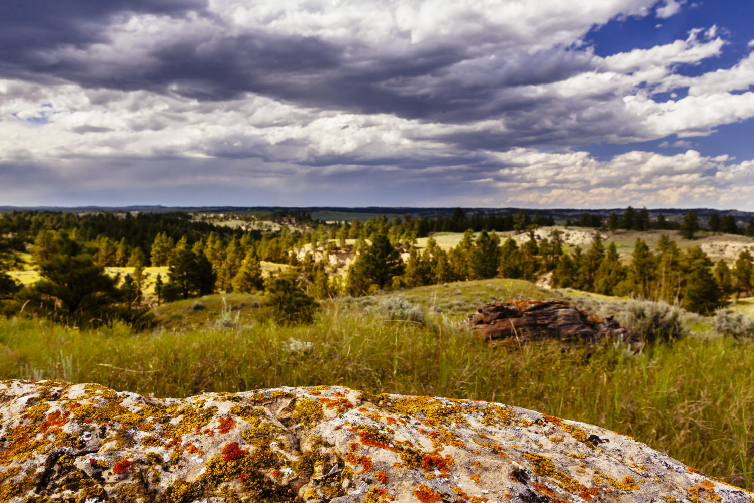
The primary reason that nearly 2,000 square miles of prime fish and wildlife habitat have vanished along Louisiana’s coast is not erosion or development. It’s just that the land is constantly sinking, a phenomenon known as subsidence. While gradual, sea-level rise is already affecting coastal areas all over the world, and Louisiana is contending with rising water and sinking land.

Sediment delivered by annual flooding on the Mississippi River used to be the key to keeping coastal wetlands above the water line. But, when that sediment flow was cut off by flood-protection and navigation levees a century ago, wetlands started disappearing.

That’s why Louisiana’s coastal master plan calls for the construction of two major diversions, one east and one west of the river below New Orleans. Two control structures and canals will be built through the levees to deliver the sediment needed to help wetlands stay above the water line, serving as critical fish and wildlife habitat and better protecting coastal communities from storm surges.

Sediment delivery brings with it freshwater inundation, which will certainly change the makeup of the fisheries in the outfall areas. To minimize impacts to fisheries, the plan is to move water and sediment only when sediment loads are at their peak and cut back, or shut off, the diversions when river flows aren’t carrying as much sediment.

Extensive modeling has been conducted to try and predict the effects of the freshwater, but biologists have been careful to point out that there’s a degree of uncertainty considering river conditions, including sediment loads, water temperatures, and weather, in any given year.

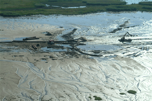
However, east of the river, near the small fishing community of Point a la Hache, hypotheticals can be replaced by a discussion of what is currently happening in the marshes, canals, bays, and lakes being inundated with freshwater and sediment from a break in the Mississippi River bank that has become known as Mardi Gras Pass.

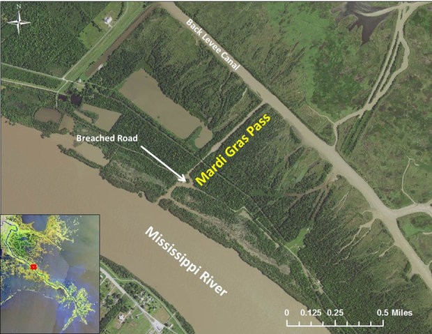
Mardi Gras Pass earned its name because the first time it was observed flowing freely from the river and down an existing canal was on Mardi Gras in 2012, a year after record flooding reshaped many areas along the east side of the Mississippi below New Orleans. The force of the flood washed away a gravel road and cut the bank around an old control structure that once allowed a limited amount of river water to spill into the area, controlling salinity and improving oyster habitat. What started as a tree-snagged trickle of less than 5,000 cubic feet per second has turned into an uncontrolled diversion that is estimated to be moving about 35,000 cubic feet per second—coincidentally, the same rate of water flow is prescribed for the diversion Louisiana has planned.

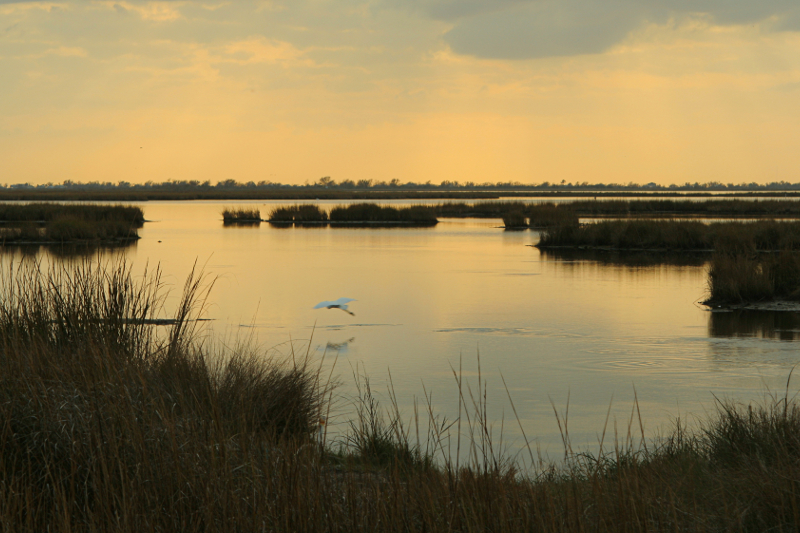
John Lopez, director of the Coastal Sustainability Program at the Lake Pontchartrain Basin Foundation, is the one who gave the new cut its name and has been studying the impacts of the natural diversion very closely. Early on, he saw schools of shad bunched up in the flowing water and has since documented a drastic increase in sediment pouring into adjacent marshes and bays. Submerged vegetation aided by the fresh water now fills ponds and bays from near the mouth of the pass out to the edges of Black Bay.

Waterfowl habitat has also improved. Bass populations have exploded in the area, and it has also become popular among tournament anglers who are finding redfish feasting on bluegills, crabs, shrimp, mullet, and crawfish. White shrimp are also more plentiful. Speckled trout, Louisiana’s most popular saltwater sportfish, have reacted to the seasonal changes in salinity by moving away from Mardi Gras Pass when the Mississippi River is high, but returning to the area when the river drops.

As is the case with any discussion of diversions, either existing or planned, not everyone is happy with the changes in the area. Oyster harvests on public oyster beds near Mardi Gras pass are down about 85 percent over the last decade, though it has been noted by Louisiana Department of Wildlife and Fisheries biologists that this decline began before the cut opened. The state’s Oyster Task Force recently voted to commit $200,000 to examine closing Mardi Gras Pass.

While the indication of negative impacts to oysters in public harvest areas and shifts in fisheries to more freshwater and freshwater-tolerant species is undeniable, closing Mardi Gras Pass would be a mistake. Controlling it with gates to maximize sediment delivery and force freshwater into adjacent marshes would be an optimal solution, especially since that’s what is recommended by those examining diversions in the Master Plan.

Simply plugging the hole and not allowing the river to flow at all is short-sighted. The Mississippi River is supposed to be connected to its adjacent wetlands. Any connection provides benefits to a sediment-starved system.

Coastal estuaries should be managed for a diverse array of fish and wildlife, not just oysters and popular sportfish species like speckled trout. If one of the primary solutions for trying to fix Louisiana’s ailing coastal wetlands is to reconnect them to the river that once built them it sure doesn’t seem to make a lot of sense to completely sever one of the few existing connections between river and marsh.


First image courtesy of LPBF.

Do you have any thoughts on this post?

XHTML: You can use these tags: <a href="" title=""> <abbr title=""> <acronym title=""> <b> <blockquote cite=""> <cite> <code> <del datetime=""> <em> <i> <q cite=""> <s> <strike> <strong>

Comments must be under 1000 characters.

September 13, 2017

What Hurricanes Can Teach Us About Building Better Coastlines with Benefits for Fish and Wildlife

While the focus should absolutely be on helping victims of recent storms, there will come a time for reflecting on how to improve coastal resilience—these lessons from Hurricanes Katrina and Rita have changed the way that Louisiana views wetlands

My lifelong home in South Louisiana has borne the brunt of more than a dozen hurricanes over the last 40 years. Each of them brought flooding rains, heavy winds, and storm surges that inundated coastal communities. Some of them, like Hurricanes Katrina and Rita, reshaped cities and lives forever.

This is why it’s especially tough to see the devastation from Hurricanes Harvey and Irma affect friends, colleagues, and the places they call home. I’ve been there before—so have my friends and neighbors. We know it could just as easily be us gutting our homes, wondering when our roads will be passable, and struggling with seemingly endless power outages.

We understand the weeks, months, and maybe years of struggle ahead. The incredibly generous outpouring of support from fellow Americans, in the form of financial donations, volunteer hours, food, and water is critical to stabilizing the situation and beginning to rebuild. But anybody who has lived through such devastation knows only time, determination, and hard work will truly bring back a sense of normalcy for those in the paths of Harvey and Irma.

The focus for those directly affected—and for all Americans—should continue to be on aid for those who have lost their homes, vehicles, and schools or are struggling to find comfort without electricity, food, or water.

There will come a time, however, after this hurricane season is over and recovery is underway, when coastal residents, community leaders, and officials will begin to assess why the damage was so extensive.

Photo by NASA Goddard Space Flight Center via Flickr
A Louisiana Case Study

That reckoning occurred in Louisiana in late 2005, after Katrina and Rita brought absolute devastation from one end of the state to the other. Building codes were analyzed. Flood plain maps were examined and updated. Evacuation plans were closely critiqued. And, perhaps most critically, scientists and engineers began examining why flood protection systems failed so miserably.

Louisiana’s elected leaders had to deal with the fact that the incredible loss of wetland habitat along the state’s coast had likely exacerbated flood damages. Combined with the poorly conceived and maintained navigation channels through wetlands, the result was a woefully inadequate flood protection system.

Louisiana acted by creating a single agency responsible for both flood protection and wetlands restoration, rather than two agencies that might need to compete for the same funds.

In 2007, less than two years after Katrina and Rita, Louisiana’s newly created Coastal Protection and Restoration Authority released the state’s first comprehensive master plan addressing coastal restoration and hurricane protection. The plan laid out a 50-year effort to create a system with multiple lines of defense, using healthier wetlands and rebuilt barrier islands as a buffer to slow wave action and storm surge before it can reach flood protection levees and flood gates. Additionally, an examination of building practices in the most frequently flooded areas, some that had experienced severe flooding seven times in ten years, led to a concerted effort to elevate homes and make businesses more resilient.

An understanding spread among lawmakers and residents that marshes and swamps are not solely places to hunt and fish. This natural infrastructure is an absolute necessity for protecting Louisiana’s largest cities as well as the smaller communities that benefit from being hunting and fishing destinations.

Photo by mammoth
Recognizing the Worth of Wetlands

For more than a century, many state and federal agencies and municipalities focused on conquering wetlands by draining them, then pumping in soils to create space for development. Wetland buffers along rivers, bayous, and creeks that once absorbed and held floodwaters were replaced by levees that force floodwaters up, instead of out. The ability of wetlands to help protect existing infrastructure was largely ignored.

It cannot be ignored any longer.

It’s true that no two storms are exactly alike: Hurricane Harvey dumped a record amount of rain that inundated a huge swath of southeast Texas, and Irma’s enormous size and unprecedented wind ferocity set it apart. Even the healthiest coastal wetlands and the best flood protection systems would not have staved off all the destruction caused by those two storms.

However, there are parts of the Houston area that have now experienced record-setting “100-year flooding” four times in the last 20 years. In Florida, communities now devastated by storm surge and river flooding could have been spared some damage if once-present mangrove flats were there to dampen wave action, or if rivers could still flush out into the wetland floodplains that no longer exist or have been cut off.

Acknowledging these facts is not an attempt to assign blame. It’s not an attempt to use unprecedented disasters to advance a political ideology, either. I understand the crassness of using these disasters as fodder for advancing an agenda while those affected try to save what few possessions remain.

I have neighbors in Baton Rouge who still have not been able to move back into their homes after record flooding in August 2016. The house that my grandfather built, where my dad grew up just two miles from Lake Pontchartrain in New Orleans, still sits empty and in disrepair more than a decade after Hurricane Katrina.

What I hope is that this will be read as a plea to those who make the decisions in coastal communities that have and have yet to be impacted by a disaster. We must grasp how important it is that we live with and utilize the natural protections for our man-made infrastructure—and perhaps think of wetlands, marshes, and mangrove flats as something just as critical to the way we live on the coast.

With personal experience as our guide, I hope we rebuild smarter in flood-prone areas, so recovery isn’t quite as difficult the next time. The side benefit just might be that we support or improve habitat that makes it possible for us to hunt, fish, and live well.

September 7, 2017

A Confirmed Decline in Hunter Participation Should Be a Call to Action for Sportsmen

It’s time for our community and decision makers to get serious about R3 efforts, adequate conservation funding, and smart policies that enhance hunters’ opportunities afield

A new report by the U.S. Fish and Wildlife Service shows that 101.6 million Americans participated in wildlife-related outdoor recreation last year. Unfortunately, while the number of people participating in fishing and wildlife-watching is up, participation in hunting dropped by about 2 million people to a total of 11.5 million hunters. Total expenditures by hunters also declined 29 percent from 2011 to 2016, from $36.3 billion to $25.6 billion.

This has significant ripple effects on not only the key federal funding models that support conservation of fish and wildlife, but also the base of support for our public lands and thoughtful natural resources policy.

“It is time for our community and our decision makers to get serious about R3, or recruitment, retention, and reactivation of hunters, because the implications for conservation are dire if this trend continues,” says Whit Fosburgh, president and CEO of the Theodore Roosevelt Conservation Partnership.

The report indicates that participation in fishing increased 8 percent since 2011, from 33.1 million anglers to 35.8 million in 2016, and total nationwide spending by anglers was up 2 percent. R3 efforts geared toward fishing and boating have been successful thanks to a funding provision in the Dingell-Johnson Act, also called the Federal Aid in Sport Fish Restoration Act, that allows a small percentage of these excise tax revenues to be used for recruitment and retention programs.

The Pittman-Robertson Act, which created the excise tax on guns, ammunition, and archery equipment, does not permit using the funds for R3 activities.

“We must modernize the Pittman-Robertson Act so we can promote hunting the same way we promote fishing and boating, bring the hunter education and licensing systems into the 21st century, and immediately address serious threats to hunting, like chronic wasting disease in deer,” says Fosburgh. “We must also focus on expanding access and improving the quality of the hunting experience—better habitat means more animals and more opportunities for success.”

Decision makers should further support the future of America’s hunting traditions by passing a fiscal year 2018 budget deal with robust funding for conservation and crafting a 2018 Farm Bill that not only enhances conservation tools for private lands but also incentivizes private landowners to enroll acres in voluntary public access programs. It is more critical than ever that sportsmen and women continue to be engaged in the public process of planning for management on America’s multiple-use public lands, as well.

It appears the USFWS will update this page with preliminary findings on the latest five-year report.

Top photo by Tim Donovan at Florida Fish and Wildlife Conservation Commission via Flickr

September 4, 2017

The Missouri River Breaks, Vibrant and Unbroken

Why conservation is our best bet at keeping central Montana unspoiled

The Missouri Breaks region of central Montana is one of the most unique landscapes in the West. The unusual topography and eroded soils—shaped by the river below and centuries of severe weather—make it a land of extremes. Yet it provides some of the best views, most outstanding recreation, and most abundant wildlife habitat in the country. Rough and rugged coulees descend into dense pockets of ponderosa pine and juniper stands before gradually reaching the cottonwood galleries that line the Missouri River.

These undeveloped backcountry lands still mirror what Lewis and Clark saw as they pushed their way upriver in 1805. We have an opportunity—and a responsibility—to ensure that they remain that way.

All images courtesy of Charlie Bulla.
A Critical Time to Speak Up

Wildlife and wild places are being increasingly pressured through the loss and fragmentation of quality habitat from energy extraction and residential development. This trend needs to be halted to protect our highly valued undeveloped landscapes. Already, much of the western and eastern stretches of the Missouri have been industrialized, dammed, or otherwise developed. But the central portion of the river—roughly from Fort Benton to Fort Peck Reservoir in Montana—remains largely untouched.

The region supports world-class habitat for elk, mule deer, and bighorn sheep, and the Missouri provides scenic multi-day fishing trips for anglers. Camping, hunting, hiking, and biking in the Breaks region are hard to beat, and stargazers will tell you that it’s difficult to find a place with less light pollution.

Most of this landscape is made up of public land that belongs to all of us and is managed by the Bureau of Land Management and the U. S. Fish and Wildlife Service. On the south side of the Missouri, where the breaks climb and meet the rugged grasslands, the BLM is in the process of updating its resource management plan.

Conservation of this unique landscape in central #Montana won’t happen on its own. #publiclandsproud Click To Tweet

This is a planning document that outlines the management of several hundred thousand acres of BLM lands for the next 20 years or more. This is also a public planning process that provides a unique and critical opportunity to protect some of the best wildlife habitat and most remote public lands in the country from further fragmentation and development.

Momentum Grows

The Theodore Roosevelt Conservation Partnership recognizes the importance of these lands to wildlife, outdoor recreationists, and sportsmen. The political landscape and threats to the region have changed since the last resource management plan was written some 30 years ago, and sportsmen and women are ready to act.

Nearly 1,000 individuals and local stakeholders have delivered collaborative support for the adoption of a common-sense approach for conserving high-value public lands through backcountry conservation management. By utilizing this tool, the BLM would safeguard large intact habitats from development, maintain and improve important dispersed recreation opportunities, and focusing management on the conservation, restoration, and enhancement of key habitats, all while sustaining traditional uses of the land that help support local economies.

Recent wildfires have devastated several hundred thousand acres of rangeland and wildlife habitat in this region. It’s important to note that the proposed backcountry management tool would encourage restoration activities that would benefit the wildlife and the people who depend on this landscape.

What’s Next?

The draft of the resource management plan is expected to be released for public comment in late 2017. Visit TRCP.org/join to be the first to know about your opportunity to get involved.

Conservation of this unique landscape won’t happen on its own. It takes strong voices to protect these areas from future fragmentation and development. As Theodore Roosevelt once said, “a nation behaves well if it treats the natural resources as assets which it must turn over to the next generation increased and not impaired in value.” Here’s a great chance for us to do just that.

August 29, 2017

It’s Time to Do More Than Just “Keep It Public”

Sportsmen have largely stamped out the public land transfer movement in the West, but it’s not enough to rally around public land ownership now that a new kind of threat is emerging in the nation’s capital

It was just two years ago when our hunting and fishing opportunities on public lands fell under siege across the West. In 2015, a total of 37 individual bills were proposed in 11 Western states, all aimed at taking away our public lands and handing them over to the states to be industrialized or sold off.

At first, sportsmen and women may have been blindsided by the intensity and breadth of this onslaught, but our community quickly reacted by organizing rallies, testifying at committee hearings, and writing elected officials about the value of public lands. These methods were effective, but in some cases, too little too late. When the dust settled on the 2015 state legislative sessions, six bills had passed in four states.

Luckily, only the federal government has the authority to sell or give away our national public lands, but this was six bills too many. Sportsmen were even more informed and vocal the following year, isolating land transfer legislation to the state of Utah in 2016. In 2017, all of these state bills have died, an indication that state legislators understand land transfer is a toxic idea, having been bombarded by the sporting community and other constituents.

Though talk of transferring public lands continues, we’ll go ahead and say it: We’ve won in the West

It’s Not Over Yet

Sportsmen and women deserve to crack open a beer in celebration of recent victories, but we should do so with eyes wide open about the next threats to our public lands: The special interests and lobbyists have brought this fight to Washington, D.C., where they are working to take over our public lands in many carefully constructed, covert ways.

They want what they’ve always wanted—control of how these lands are managed, so they can open them up to unfettered development. Management, not ownership, was always the ultimate goal, and there are three primary ways to gain it:

The wholesale transfer or sale of national public lands to the states, what we’ve been fighting since 2015, was just the first attempt and some are still pushing it. Cover image courtesy of the BLM/flickr.
Transfer Ownership

The wholesale transfer or sale of national public lands to the states, what we’ve been fighting since 2015, was just the first attempt and some are still pushing it.

It’s not enough to simply #keepitpublic now as a new #publiclands threat emerges in D.C. Click To Tweet
Transfer Management

Giving local or state agencies the authority to manage America’s public lands while they remain in federal ownership may sound better, but it will have essentially the same outcome as giving away our lands. Let me be clear, we fully support existing state authority over fish and wildlife management, and we do not want to see that authority eroded. What we are talking about here is control over the management of your public lands, an entirely separate issue. By handing states management authority over public lands, BLM and national forest lands would be managed like school trust lands, where profit is king and outdoor recreation, like hunting and fishing, is an afterthought.

Negating the multiple-use mandate on federal lands would mean losing a carefully crafted balance between hunting, fishing, timber, grazing, and energy extraction. We’ve recently seen versions of this model proposed through the Self-Sufficient Community Lands Act, which would enable states to take over the management of national public lands for industrial forest production, and a proposal from Congressman Rob Bishop that would give states veto authority over the management of sage-grouse habitat.

This method is basically land transfer disguised in more subtle packaging, and lawmakers are counting on the fact that you won’t understand their true intentions. But we see right through it.

Rewrite the Rules

If special interest groups don’t like the rules for balancing the many uses of public lands or taking local input into account on land management decisions, well then why not just change them? That’s essentially what they’re trying to do right now.

Earlier this year, the Trump administration seemed focused on rolling out a new executive order weekly to review or revise the rules guiding the management of our public lands. Now, a review of 11.3 million acres of existing national monuments is in (though the administration has yet to act on them) and DOI has completed a study focused on eliminating ‘burdens’ to energy production.

These processes may create opportunities for special interests to rewrite the rules of public-lands management and remove conservation standards for fish and wildlife, while smoothing the way for industrial development. It’s imperative that sportsmen remain closely involved when the rules are being evaluated or rewritten to ensure that our interests and the needs of fish and wildlife get a fair shake in the process.

How Sportsmen Can Win

Land transfer is bad news on its face—it’s always been easy for sportsmen to recognize that and say ‘no way.’ Attacks on how our public lands are managed are sneaky and lower profile, cloaked in confusing policy, yet every bit as dangerous.

The good news is that America’s public lands are still ours—they are a part of what makes our country unique and we still have a say. But our job is more difficult now. We need to remain as fired up as we have been about keeping public lands in public hands AND hold lawmakers accountable for subtle attacks on public land management.

These threats aren’t always easy to explain and don’t fit nicely on a bumper sticker, but that’s why we’re so committed to keeping you informed.

Head over to the new Sportsmen’s Country page to learn more about the not-so-obvious challenges we face on our public lands, because access means nothing without opportunity. Ownership of public lands is meaningless without quality habitat and abundant wildlife to pursue when we’re out there. If we rally around one and ignore the other, it’s possible for decision makers to make access promises while voting to undermine everything we want access to.

Sign the Sportsmen’s Country petition now and do more than keep it public.

This was originally posted May 31, 2017, and has been updated.

HOW YOU CAN HELP

CHEERS TO CONSERVATION

Theodore Roosevelt’s experiences hunting and fishing certainly fueled his passion for conservation, but it seems that a passion for coffee may have powered his mornings. In fact, Roosevelt’s son once said that his father’s coffee cup was “more in the nature of a bathtub.” TRCP has partnered with Afuera Coffee Co. to bring together his two loves: a strong morning brew and a dedication to conservation. With your purchase, you’ll not only enjoy waking up to the rich aroma of this bolder roast—you’ll be supporting the important work of preserving hunting and fishing opportunities for all.

Learn More
Subscribe

You have Successfully Subscribed!

You have Successfully Subscribed!

You have Successfully Subscribed!

You have Successfully Subscribed!

You have Successfully Subscribed!